Advanced Search
Search across all country profiles and data fields
Found 100 results for "island nation"
Background
Polynesians lived on Norfolk Island between 1200 and 1500, but the remote island was uninhabited by the time British explorer James COOK landed on the island in 1774. Two British attempts at establishing the island as a penal colony (1788-1814 and 1825-55) were ultimately abandoned.<br><br>In 1856, almost 200 Pitcairn Islanders -- descendants of the <em>Bounty </em>mutineers and their Tahitian com...
Background
<p>All of the following US Pacific Island territories except Midway Atoll constitute the Pacific Remote Islands National Wildlife Refuge (NWR) Complex and as such are managed by the Fish and Wildlife Service of the US Department of the Interior. Midway Atoll NWR has been included in a Refuge Complex with the Hawaiian Islands NWR and also designated as part of Papahanaumokuakea Marine National Monu...
Background
<p>Saint Helena is a British Overseas Territory off the coast of Africa in the South Atlantic Ocean, and it consists of Saint Helena, Ascension Island, and the island group of Tristan da Cunha.</p> <p><strong>Saint Helena:</strong> The island was uninhabited when the Portuguese first discovered it in 1502, and the British garrisoned troops on Saint Helena during the 17th century. It acquired fame ...
Background
<p>Early Micronesian and Polynesian settlers probably visited Wake Island, and oral legends tell of periodic voyages to the islands by people from the Marshall Islands. Wake Island was uninhabited when Spanish explorer Alvaro de Mendana de NEYRA became the first European to see it in 1568 and still had no inhabitants when English captain Samuel WAKE sailed by it in 1796. The United States Explorin...

Background
In 2007, the Iles Eparses became an integral part of the French Southern and Antarctic Lands (TAAF). The Southern Lands are now divided into five administrative districts, two of which are archipelagos, the Iles Crozet and Iles Kerguelen; the third is a district composed of two volcanic islands, Ile Saint-Paul and Ile Amsterdam; the fourth, Iles Eparses, consists of five scattered tropical islands...

Military - note
around 70 disputed islets and reefs in the Spratly Islands are occupied by China, Malaysia, the Philippines, Taiwan, and Vietnam<br><br><strong>China: </strong>occupies seven outposts (Fiery Cross, Mischief, Subi, Cuarteron, Gavin, Hughes, and Johnson reefs); the outposts on Fiery Cross, Mischief, and Subi include air bases with helipads and aircraft hangers, naval port facilities, surveillance ra...
Background
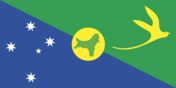
Although Europeans sighted Christmas Island in 1615, it was named for the day of its rediscovery in 1643. Steep cliffs and dense jungle hampered attempts to explore the island over the next two centuries. The discovery of phosphate on the island in 1887 led to the UK annexing it the following year. In 1898, 200 Chinese indentured servants were brought in to work the mines, along with Malays, Sikhs...

Coastline › note
<strong>note:</strong> 95 nations and other entities are islands that border no other countries: American Samoa, Anguilla, Antigua and Barbuda, Aruba, Ashmore and Cartier Islands, The Bahamas, Bahrain, Baker Island, Barbados, Bermuda, Bouvet Island, British Indian Ocean Territory, British Virgin Islands, Cabo Verde, Cayman Islands, Christmas Island, Clipperton Island, Cocos (Keeling) Islands, Como...
Dependent areas
Australia dependencies: Ashmore and Cartier Islands, Christmas Island, Cocos (Keeling) Islands, Coral Sea Islands, Heard Island and McDonald Islands, Norfolk Island (6)<br><br>France dependencies: Clipperton Island, French Polynesia, French Southern and Antarctic Lands, New Caledonia, Saint Barthelemy, Saint Martin, Saint Pierre and Miquelon, Wallis and Futuna (8)<br><br>New Zealand dependency: To...

Background
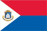
Christopher COLUMBUS claimed Saint Martin for Spain in 1493, naming it after the feast day of St. Martin of Tours, but it was the Dutch who occupied the island in 1631 to exploit its salt deposits. The Spanish retook Saint Martin in 1633, but the Dutch continued to assert their claims. The Spanish finally relinquished the island to the French and Dutch, who divided it between themselves in 1648. T...
Background
This uninhabited volcanic island in Antarctica is almost entirely covered by glaciers, making it difficult to approach. Bouvet Island is recognized as the most remote island on Earth because it is furthest from any other point of land (1,639 km from Antarctica). The island was named after the French naval officer who discovered it in 1739, although no country laid claim to it until 1825, when the ...
Background
Polynesians were the first settlers on the four tiny islands that are now called the Pitcairn Islands, but all four were uninhabited by the time Europeans discovered them in 1606. Pitcairn Island -- the only one now inhabited -- was rediscovered by a British explorer in 1767. In 1789, Fletcher CHRISTIAN led a mutiny on the HMS Bounty, and after several months of searching for Pitcairn Island, he l...

Background
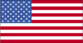
<p>Thirteen of Britain's American colonies broke with the mother country in 1776 and were recognized as the new nation of the United States of America following the Treaty of Paris in 1783. During the 19th and 20th centuries, 37 new states were added as the nation expanded across the North American continent and acquired a number of overseas possessions. Two of the most traumatic experiences in th...
Background
<p>Voyagers from Samoa first settled on Niue around A.D. 900, and a second main group of settlers came from Tonga around 1500. With only one reliable source of fresh water, conflict was high on the island. Samoan and Tongan customs heavily influenced Niuean culture, including the formation of an island-wide elected kingship system in the early 1700s. In 1774, British explorer James COOK landed on ...
Administrative divisions
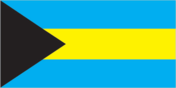
31 districts; Acklins Islands, Berry Islands, Bimini, Black Point, Cat Island, Central Abaco, Central Andros, Central Eleuthera, City of Freeport, Crooked Island and Long Cay, East Grand Bahama, Exuma, Grand Cay, Harbour Island, Hope Town, Inagua, Long Island, Mangrove Cay, Mayaguana, Moore's Island, North Abaco, North Andros, North Eleuthera, Ragged Island, Rum Cay, San Salvador, South Abaco, Sou...
Terrain
<strong>Ile Amsterdam (Ile Amsterdam et Ile Saint-Paul):</strong> a volcanic island with steep coastal cliffs; the center floor of the volcano is a large plateau<br><br><strong>Ile Saint-Paul (Ile Amsterdam et Ile Saint-Paul):</strong> triangular in shape, the island is the top of a volcano, rocky with steep cliffs on the eastern side; has active thermal springs<br><br><strong>Iles Crozet:</strong...
Background
<p>Indonesian fishermen have long fished in the area around Ashmore Reef and Cartier Island. British explorers were the first Europeans to see Cartier Island and Ashmore Reef in 1800 and 1811, respectively. American whalers frequently sailed by the islands in the 1850s and later settled to mine the phosphate deposits on Ashmore Reef, which were exhausted by 1891. The UK disputed US access to Ashmo...
Background
<p>Guam was settled by Austronesian people around 1500 B.C. These people became the indigenous Chamorro and were influenced by later migrations, including the Micronesians in the first millennium A.D., and island Southeast Asians around 900. Society was stratified, with higher classes living along the coast and lower classes living inland. Spanish explorer Ferdinand MAGELLAN was the first European...
Geography - note
<strong>note 1:</strong> consists of two main islands and a number of smaller islands; South Island, the larger main island, is the 12th-largest island in the world and is divided along its length by the Southern Alps; North Island is the 14th-largest island in the world and is not as mountainous, but it is marked by volcanism <br><br><strong>note 2:</strong> New Zealand lies along the Ring of Fir...
Background
Christopher COLUMBUS claimed Saint Martin for Spain in 1493, naming it after the feast day of St. Martin of Tours, but it was the Dutch who occupied the island in 1631 to exploit its salt deposits. The Spanish retook Saint Martin in 1633, but the Dutch continued to assert their claims. The Spanish finally relinquished the island to the French and Dutch, who divided it between themselves in 1648. T...
Background
In 1493, Christopher COLUMBUS named Saint Barthelemy for his brother Bartolomeo, but the island was first settled by the French in 1648. In 1784, France sold the island to Sweden, which renamed the largest town Gustavia after the Swedish King GUSTAV III and made it a free port; the island prospered as a trade and supply center during the colonial wars of the 18th century. France repurchased the is...
Geography - note
islands are widely scattered across remote locations in the southern Indian Ocean <br><br><strong>Bassas da India (Iles Éparses):</strong> atoll is a circular reef on top of a long-extinct, submerged volcano <br><br><strong>Europa Island and Juan de Nova Island (Iles Éparses):</strong> wildlife sanctuary for seabirds and sea turtles <br><br><strong>Glorioso Island (Iles Éparses):</strong> an exten...
Dependent areas
American Samoa, Baker Island, Guam, Howland Island, Jarvis Island, Johnston Atoll, Kingman Reef, Midway Islands, Navassa Island, Northern Mariana Islands, Palmyra Atoll, Puerto Rico, Virgin Islands, Wake Island (14)

Background
<p>American sailor John HEARD discovered Heard Island in 1853 while fellow American William MCDONALD discovered the McDonald Islands the following year. Starting in 1855, sealers lived on the islands and harvested elephant seal oil; by the time the practice was ended in 1877, most of the islands’ seals were killed. The UK formally claimed the islands in 1910, and Australian explorer Douglas MAWSON...
Background
By 1000 B.C., Micronesian and Polynesian settlers inhabited Nauru, and the island was divided among 12 clans. Nauru developed in relative isolation because ocean currents made landfall on the island difficult. As a result, the Nauruan language does not clearly resemble any other in the Pacific region. In 1798, a British mariner was the first European to spot the island and by 1830, European whaler...
Geography - note
<strong>Baker, Howland, and Jarvis Islands:</strong> scattered vegetation consisting of grasses, vines, and low-growing shrubs; primarily a nesting, roosting, and foraging habitat for seabirds, shorebirds, and marine wildlife; closed to the public <br><br><strong>Johnston Atoll:</strong> Johnston Island and Sand Island are natural islands that have been expanded by coral dredging; North Island (Ak...
Location
Oceania <br><br><strong>Baker Island:</strong> atoll in the North Pacific Ocean 3,390 km southwest of Honolulu, about halfway between Hawaii and Australia<br><br><strong>Howland Island:</strong> island in the North Pacific Ocean 3,360 km southwest of Honolulu, about halfway between Hawaii and Australia<br><br><strong>Jarvis Island:</strong> island in the South Pacific Ocean 2,415 km south of Honol...
National heritage › Selected World Heritage Site locales
Buddhist Monuments in the Horyu-ji Area (c); Historic Monuments of Ancient Nara (c); Himeji-jo (c); Shiretoko (n); Mozu-Furuichi Kofun Group: Mounded Tombs of Ancient Japan (c); Jomon Prehistoric Sites in Northern Japan (c); Yakushima (n); Historic Monuments of Ancient Kyoto (Kyoto, Uji and Otsu Cities) (c); Hiroshima Peace Memorial (Genbaku Dome) (c); Shirakami-Sanchi (n); Historic Villages of Sh...
Country name › Etymology
on the feast day of Saint Helena in 1502, Spanish navigator Joao da NOVA (sailing for Portugal) sighted and named the island that now bears the saint's name; da NOVA originally named Ascension "Conception Island" in honor of the Virgin Mary, but Portuguese navigator Afonso de ALBUQUERQUE later found the island on the feast day of the Ascension in 1508 and renamed it; Portuguese explorer Tristao da...
National coat of arms
Norfolk Island is part of the Commonwealth of Australia, and in 1980, Queen Elizabeth II granted it a separate coat of arms (pictured); in the center is the island’s symbol, the Norfolk Island Pine, with Britain’s lion and Australia’s kangaroo supporting the shield; the island’s motto, “Inasmuch,” comes from a verse in the Bible’s Gospel of Matthew
Elevation › Highest point
Baker Island, unnamed location 8 m; Howland Island, unnamed location 3 m; Jarvis Island, unnamed location 7 m; Johnston Atoll, Sand Island 10 m; Kingman Reef, unnamed location 2 m; Midway Islands, unnamed location less than 13 m; Palmyra Atoll, unnamed location 3 m
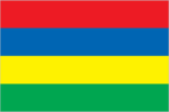
Background
<p>Although known to Arab and European sailors since at least the early 1500s, the island of Mauritius was uninhabited until 1638 when the Dutch established a settlement named in honor of Prince Maurits van NASSAU. Their presence led to the rapid disappearance of the flightless dodo bird that has since become one of the most well-known examples of extinction in modern times. The Dutch abandoned th...
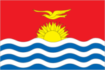
Background
Kiribati is made up of three distinct island groups -- the Gilbert Islands, the Line Islands, and the Phoenix Islands. The first Austronesian voyagers arrived in the Gilbert Islands as early as 3000 B.C., but these islands were not widely settled until about A.D. 200 by Micronesians. Around 1300, Samoans and Tongans invaded the southern Gilbert Islands, then known as Tungaru, bringing Polynesian c...
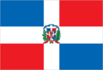
Background
The Taino -- indigenous inhabitants of Hispaniola prior to the arrival of Europeans -- divided the island now known as the Dominican Republic and Haiti into five chiefdoms and territories. Christopher COLUMBUS explored and claimed the island on his first voyage in 1492; it became a springboard for Spanish conquest of the Caribbean and the American mainland. In 1697, Spain recognized French dominio...
Natural hazards
occasional floods; severe droughts; tsunamis; earthquakes; volcanoes; forest fires <br><br><strong>volcanism:</strong> Indonesia contains the most volcanoes of any country in the world, with over 75 historically active; significant volcanic activity occurs on Java, Sumatra, the Sunda Islands, Halmahera Island, Sulawesi Island, Sangihe Island, and in the Banda Sea; Merapi (2,968 m), Indonesia's mos...
Elevation › Note
<strong>top ten highest mountains (measured from sea level):</strong> Mount Everest (China-Nepal) 8,849 m; K2 (China-Pakistan) 8,611 m; Kanchenjunga (India-Nepal) 8,586 m; Lhotse (China-Nepal) 8,516 m; Makalu (China-Nepal) 8,485 m; Cho Oyu (China-Nepal) 8,188 m; Dhaulagiri (Nepal) 8,167 m; Manaslu (Nepal) 8,156 m; Nanga Parbat (Pakistan) 8,125 m; Annapurna (Nepal) 8,091 m; <br><br><strong>note:</s...
People - note
Indonesia is the fourth most populous nation in the World after China, India, and the United States; more than half of the Indonesian population - roughly 150 million people or 55% - live on the island of Java (about the size of California) making it the most crowded island on earth
Political parties
Bhumjaithai Party or BJT (aka Phumchai Thai Party or PJT; aka Thai Pride Party) <br>Chat Thai Phatthana Party (Thai Nation Development Party) or CTP<br>Democrat Party <br>Move Forward Party or MFP (dissolved by order of the Constitutional Court, August 2024)<br>Palang Pracharat Party (People's State Power Party) or PPRP <br>Pheu (Puea) Thai Party (For Thais Party) or PTP <br>Prachachat Party or PC...
Military - note
the EU partners with the North Atlantic Treaty Organization (NATO); NATO is an alliance of 32 countries from North America and Europe; its role is to safeguard the security of its member countries by political and military means; NATO conducts crisis management and peacekeeping missions; member countries that participate in the military aspect of the Alliance contribute forces and equipment, which...
Geography - note
world's fourth-largest island; strategic location along Mozambique Channel; despite Madagascar’s close proximity to the African continent, ocean currents isolate the island, resulting in high rates of endemic plant and animal species; approximately 90% of the flora and fauna on the island are found nowhere else
Country name › Etymology
named for an offshore island; the island was named after Mussa bin BIQUE (or Mussa Ibn MALIK), an influential Arab slave trader who set himself up as sultan on the island in the 15th century
Coastline
<strong>Ile Amsterdam (Ile Amsterdam et Ile Saint-Paul): </strong>28 km<br> <strong>Ile Saint-Paul (Ile Amsterdam et Ile Saint-Paul): </strong><br> <strong>Iles Kerguelen: </strong>2,800 km<br> <strong>Bassas da India (Iles Eparses): </strong>35.2 km<br> <strong>Europa Island (Iles Eparses): </strong>22.2 km<br> <strong>Glorioso Islands (Iles Eparses): </strong>35.2 km<br> <strong>Juan de Nova Isl...
Elevation › Note
<strong>highest points throughout the French Southern and Antarctic Lands:</strong> Crête de la Novara on Ile Saint-Paul (Ile Amsterdam et Ile Saint-Paul) 284 m; Pic Marion-Dufresne in Iles Crozet 1090 m; Mont Ross in Iles Kerguelen 1850 m; unnamed location on Bassas de India (Iles Eparses) 2.4 m; 24 unnamed location on Europa Island (Iles Eparses) 6 m; unnamed location on Glorioso Islands (Iles E...
Location
southeast and east of Africa, islands in the southern Indian Ocean, some near Madagascar and others about equidistant between Africa, Antarctica, and Australia; note - French Southern and Antarctic Lands include Ile Amsterdam, Ile Saint-Paul, Iles Crozet, Iles Kerguelen, Bassas da India, Europa Island, Glorioso Islands, Juan de Nova Island, and Tromelin Island in the southern Indian Ocean, along w...

Dependent areas
Ashmore and Cartier Islands, Christmas Island, Cocos (Keeling) Islands, Coral Sea Islands, Heard Island and McDonald Islands, Jervis Bay, Norfolk Island (7)
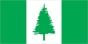
Flag
<strong>description:</strong> three vertical bands of green (left side), white, and green, with a large green Norfolk Island pine tree centered on the white band<br><br><strong>meaning:</strong> green stands for the island's rich vegetation, and the native pine tree is an island symbol
Natural hazards
earthquakes are common, though usually not severe; volcanic activity <br><br><strong>volcanism:</strong> significant volcanism on North Island; Ruapehu (2,797 m) has a history of large eruptions in the past century; Taranaki has the potential to produce dangerous avalanches and lahars; other historically active volcanoes include Okataina, Raoul Island, Tongariro, and White Island; see note 2 under...
Environmental issues
<strong>Baker Island: </strong>no natural freshwater resources<br><strong><br>Howland Island: </strong>no natural freshwater resources<br><br><strong>Jarvis Island</strong><strong>:</strong> no natural freshwater resources<br><strong><br>Johnston Atoll: </strong>no natural freshwater resources; invasion of non-native species<br><strong><br>Midway Islands:</strong> pollution from plastic; predomina...
Coastline
<strong>Baker Island: </strong>4.8 km<br> <strong>Howland Island: </strong>6.4 km<br> <strong>Jarvis Island: </strong>8 km<br> <strong>Johnston Atoll: </strong>34 km<br> <strong>Kingman Reef: </strong>3 km<br> <strong>Midway Islands: </strong>15 km<br> <strong>Palmyra Atoll: </strong>14.5 km
Geographic coordinates
<strong>Baker Island:</strong> 0 13 N, 176 28 W <br><br><strong>Howland Island:</strong> 0 48 N, 176 38 W <br><br><strong>Jarvis Island:</strong> 0 23 S, 160 01 W <br><br><strong>Johnston Atoll:</strong> 16 45 N, 169 31 W <br><br><strong>Kingman Reef:</strong> 6 23 N, 162 25 W <br><br><strong>Midway Islands:</strong> 28 12 N, 177 22 W <br><br><strong>Palmyra Atoll:</strong> 5 53 N, 162 05 W
Country name › Conventional short form
Baker Island, Howland Island, Jarvis Island, Johnston Atoll, Kingman Reef, Midway Islands, Palmyra Atoll
Country name › Etymology
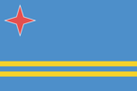
the origin of the island's name is unclear; according to tradition, the name comes from the Spanish phrase <em>oro hubo</em> ("there was gold"), but no gold was ever found on the island; other possible sources are either the local word <em>oruba</em> ("well-situated") or a combination of two Carib Indian words, <em>ora </em>and <em>oubao</em> ("shell" and "island," respectively)
Background
The US claimed uninhabited Navassa Island in 1857 for its guano. Mining took place between 1865 and 1898. The lighthouse, built in 1917, was shut down in 1996, and administration of Navassa Island was transferred from the US Coast Guard to the Department of the Interior, Office of Insular Affairs. A 1998 scientific expedition to the island described it as a "unique preserve of Caribbean biodiversi...
Natural hazards
volcanic eruptions; severe hurricanes (June to November) <br><br><strong>volcanism:</strong> Soufrière Hills volcano (915 m) has erupted continuously since 1995; a massive eruption in 1997 destroyed most of the capital, Plymouth, and made about half of the island uninhabitable; the island of Montserrat is part of the volcanic island arc of the Lesser Antilles that extends from Saba in the north to...
Background
English and Irish colonists from St. Kitts first settled on Montserrat in 1632; the first African slaves arrived three decades later. The British and French fought for possession of the island for most of the 18th century, but it finally was confirmed as a British possession in 1783. The island's sugar plantation economy was converted to small farm landholdings in the mid-19th century. The Soufrie...
Country name › Etymology
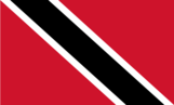
explorer Christopher COLUMBUS named the larger island "La Isla de la Trinidad" (The Island of the Trinity) in 1498, possibly because of the three mountain peaks on the island; COLUMBUS may have gotten the name Tobago, spelled "tobaco" in Spanish, from the tobacco grown and smoked locally, or from its elongated cigar shape
Natural hazards
hurricanes; La Soufrière volcano on the island of Saint Vincent is a constant threat<br><br><strong>volcanism:</strong> La Soufrière (1,234 m) last erupted in 1979; the island of Saint Vincent is part of the volcanic-island arc of the Lesser Antilles that extends from Saba in the north to Grenada in the south
Country name › Etymology
the origin is unclear; the name may come from the ancient term <em>mel</em>, meaning "high" and probably referring to the island's rocks; the ancient Greeks called the island "Melite," possibly from the Greek word <em>meli,</em> meaning "honey" and referring to the island's honey production
Natural hazards
flooding <br><br><strong>volcanism:</strong> Mount Scenery (887 m), located on the island of Saba in the Caribbean, last erupted in 1640; Round Hill (601 m), a dormant volcano also known as "The Quill," is located on the island of St. Eustatius in the Caribbean; these islands are at the northern end of the volcanic island arc of the Lesser Antilles that extends south to Grenada
Background
For centuries prior to colonization in the 19th century, the Comoros archipelago in the Indian Ocean served as a key node in maritime trade networks that connected the Middle East, India, and eastern African regions. Composed of the islands of Anjouan, Mayotte, Moheli, and Grande Comore, Comoros spent most of the 20th century as a colonial outpost until it declared independence from France on 6 Ju...
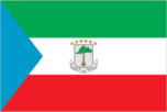
Background
Equatorial Guinea consists of a continental territory and five inhabited islands; it is one of the smallest countries by area and population in Africa. The mainland region was most likely predominantly inhabited by Pygmy ethnic groups prior to the migration of various Bantu-speaking ethnic groups around the second millennium BC. The island of Bioko, the largest of Equatorial Guinea’s five inhabite...
Background
Madagascar was one of the last major habitable landmasses on earth to be settled by humans. While there is some evidence of human presence on the island in the millennia B.C., large-scale settlement began between A.D. 350 and 550 with settlers from present-day Indonesia. The island attracted Arab and Persian traders as early as the 7th century, and migrants from Africa arrived around A.D. 1000. Ma...
Area
<strong>Ile Amsterdam (Ile Amsterdam et Ile Saint-Paul): </strong>total - 55 sq km; land - 55 sq km; water - 0 sq km<br><br><strong>Ile Saint-Paul (Ile Amsterdam et Ile Saint-Paul): </strong>total - 7 sq km; land - 7 sq km; water - 0 sq km<br><br><strong>Iles Crozet: </strong>total - 352 sq km; land - 352 sq km; water - 0 sq km<br><br><strong>Iles Kerguelen: </strong>total - 7,215 sq km; land - 7,...
Area - comparative
<strong>Ile Amsterdam (Ile Amsterdam et Ile Saint-Paul):</strong> less than one-half the size of Washington, D.C. <br><br><strong>Ile Saint-Paul (Ile Amsterdam et Ile Saint-Paul):</strong> more than 10 times the size of the National Mall in Washington, D.C. <br><br><strong>Iles Crozet:</strong> about twice the size of Washington, D.C. <br><br><strong>Iles Kerguelen:</strong> slightly larger than D...
Geographic coordinates
<strong>Ile Amsterdam (Ile Amsterdam et Ile Saint-Paul):</strong> 37 50 S, 77 32 E <br><br><strong>Ile Saint-Paul (Ile Amsterdam et Ile Saint-Paul):</strong> 38 72 S, 77 53 E <br><br><strong>Iles Crozet:</strong> 46 25 S, 51 00 E <br><br><strong>Iles Kerguelen:</strong> 49 15 S, 69 35 E <br><br><strong>Bassas da India (Iles Eparses):</strong> 21 30 S, 39 50 E <br><br><strong>Europa Island (Iles Ep...
Population › Note
<strong>Ile Amsterdam (Ile Amsterdam et Ile Saint-Paul)</strong>: uninhabited but has a meteorological station<br><strong>Ile Saint-Paul (Ile Amsterdam et Ile Saint-Paul)</strong>: uninhabited but is visited by fishermen and researchers<br><strong>Iles Crozet</strong>: uninhabited except for staff of the Alfred Faure research station on Ile del la Possession<br><strong>Iles Kerguelen</strong>: res...
Area › Note
<strong>Baker Island: </strong>total - 129.1 sq km; emergent land - 2.1 sq km; submerged - 127 sq km<br><br><strong>Howland Island: </strong>total - 138.6 sq km; emergent land - 2.6 sq km; submerged - 136 sq km<br><br><strong>Jarvis Island: </strong>total - 152 sq km; emergent land - 5 sq km; submerged - 147 sq km<br><br><strong>Johnston Atoll: </strong>total - 276.6 sq km; emergent land - 2.6 sq ...
Area - comparative
<strong>Baker Island:</strong> about 2.5 times the size of the National Mall in Washington, D.C.<br><br><strong>Howland Island:</strong> about three times the size of the National Mall in Washington, D.C.<br><br><strong>Jarvis Island:</strong> about eight times the size of the National Mall in Washington, D.C.<br><br><strong>Johnston Atoll:</strong> about 4.5 times the size of the National Mall in...
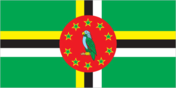
Natural hazards
flash floods are a constant threat; destructive hurricanes can be expected during the late summer months <br><br><strong>volcanism:</strong> Dominica lies in the middle of the volcanic-island arc of the Lesser Antilles that extends from the island of Saba in the north to Grenada in the south; of the 16 volcanoes that make up this arc, five are located on Dominica, more than any other island in the...
Background
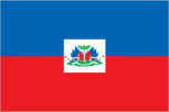
<p>The native Taino -- who inhabited the island of Hispaniola when Christopher COLUMBUS first landed in 1492 -- were virtually wiped out by Spanish settlers within 25 years. In the early 17th century, the French established a presence on Hispaniola. In 1697, Spain ceded to the French the western third of the island, which later became Haiti. The French colony, based on forestry and sugar-related i...
Background
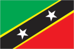
Carib Indians occupied the islands of the West Indies for hundreds of years before the British and French began settlement in 1623. During the 17th century, Saint Kitts became the premier base for British and French expansion into the Caribbean. The French ceded the territory to the UK in 1713. At the turn of the 18th century, Saint Kitts was the richest British Crown Colony per capita in the Cari...
Background
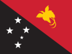
<p>Papua New Guinea (PNG) occupies the eastern half of the island of New Guinea; the western half is part of Indonesia. PNG was first settled between 50,000 and 60,000 years ago. Its harsh geography of mountains, jungles, and numerous river valleys kept many of the arriving groups isolated, giving rise to PNG’s ethnic and linguistic diversity. Around 500 B.C., Austronesian voyagers settled along t...
Background
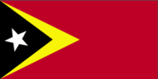
<p>The island of Timor was actively involved in Southeast Asian trading networks for centuries, and by the 14th century, it exported sandalwood, slaves, honey, and wax. The sandalwood trade attracted the Portuguese, who arrived in the early 16th century; by mid-century, they had colonized the island, which was previously ruled by local chieftains. In 1859, Portugal ceded the western portion of the...
Background
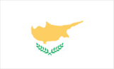
A former British colony, Cyprus became independent in 1960 after years of resistance to British rule. Tensions between the Greek Cypriot majority and Turkish Cypriot minority came to a head in December 1963, when violence broke out in the capital of Nicosia. Despite the deployment of UN peacekeepers in 1964, sporadic intercommunal violence continued and forced most Turkish Cypriots into enclaves t...

Location
<strong>metropolitan France:</strong> Western Europe, bordering the Bay of Biscay and English Channel, between Belgium and Spain, southeast of the UK; bordering the Mediterranean Sea, between Italy and Spain<br><br><strong>French Guiana:</strong> Northern South America, bordering the North Atlantic Ocean, between Brazil and Suriname<br><br><strong>Guadeloupe:</strong> Caribbean, islands between th...
Area - rankings
<p><strong>top fifteen World Factbook entities ranked by size:</strong> Pacific Ocean 155,557,000 sq km; Atlantic Ocean 76,762,000 sq km; Indian Ocean 68,556,000 sq km; Southern Ocean 20,327,000 sq km; Russia 17,098,242 sq km; Antarctica 14,200,000 sq km; Arctic Ocean 14,056,000 sq km; Canada 9,984,670 sq km; United States 9,826,675 sq km; China 9,596,960 sq km; Brazil 8,515,770 sq km; Australia 7...
Population distribution
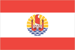
the majority of the population lives in the Society Islands, one of five archipelagos that includes the most populous island, Tahiti, with approximately 70% of the nation's population

Population distribution
over two thirds of the population lives on the island of Tongatapu; only 45 of the nation's 171 islands are occupied
Geography - note
shares island of Hispaniola with Dominican Republic (western one-third is Haiti, eastern two-thirds is the Dominican Republic); it is the most mountainous nation in the Caribbean
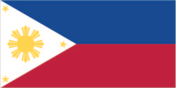
National coat of arms
the coat of arms was adopted on 3 July 1946; the three gold stars represent the major island groups of Luzon, the Visayas, and Mindanao; the rays of the sun represent the provinces of the Philippines; the American eagle and lion of Spain represent the nation's colonial past
Background
<p>The Dutch United Provinces declared their independence from Spain in 1581; during the 17th century, they became a leading seafaring and commercial power, with settlements and colonies around the world. After 18 years of French domination, the Netherlands regained its independence in 1813. In 1830, Belgium seceded and formed a separate kingdom. The Netherlands remained neutral in World War I but...
Background
<p>The United Kingdom of Great Britain and Northern Ireland was created when the Kingdoms of England and Scotland -- which previously had been distinct states under a single monarchy -- were joined under the 1707 Acts of Union. The island of Ireland was incorporated under the 1800 Acts of Union, while Wales had been part of the Kingdom of England since the 16th century. The United Kingdom has hist...
Population distribution
among the nine inhabited islands, population distribution is variable; islands in the east are very dry and are only sparsely settled; the more southerly islands receive more precipitation and support larger populations; approximately half of the population lives on Sao Tiago Island, which is the location of the capital of Praia; Mindelo, on the northern island of Sao Vicente, also has a large urb...
Population distribution
population density is one of the highest in the world; urban clusters are found throughout the main island, with a greater density in and around Port Luis; the population on Rodrigues Island is fairly evenly spread, with a slightly denser cluster on the north coast, as shown in this population distribution map
Area › Note
<strong>note:</strong> includes Prince Edward Islands (Marion Island and Prince Edward Island)

National heritage › Selected World Heritage Site locales
Island of Gorée (c); Niokolo-Koba National Park (n); Djoudj National Bird Sanctuary (n); Island of Saint-Louis (c); Stone Circles of Senegambia (c); Saloum Delta (c); Bassari Country: Bassari, Fula, and Bedik Cultural Landscapes (c)
Broadcast media
<em>Saint Helena</em>: no local TV station; 2 local radio stations, one of which is relayed to Ascension Island; satellite TV stations rebroadcast terrestrially<br><br><em>Ascension Island</em>: no local TV station; 1 local radio station and receives relays of broadcasts from radio station on Saint Helena; broadcasts from the British Forces Broadcasting Service (BFBS) available, as well as US mili...
Area › Note
88 sq km Ascension Island, 184 sq km Tristan da Cunha island group (includes Tristan (98 sq km), Inaccessible, Nightingale, and Gough islands)
Coastline
<strong>Saint Helena: </strong>60 km<br> <strong>Ascension Island: </strong>NA<br> <strong>Tristan da Cunha (island only): </strong>34 km
Elevation › Highest point
Queen Mary's Peak on Tristan da Cunha 2,060 m; Green Mountain on Ascension Island 859 m; Diana's Peak on Saint Helena Island 818 m
Geographic coordinates
<strong>Saint Helena:</strong> 15 57 S, 5 42 W <p><strong>Ascension Island:</strong> 7 57 S, 14 22 W</p> <strong>Tristan da Cunha island group:</strong> 37 15 S, 12 30 W
National heritage › Selected World Heritage Site locales
Gebel Barkal and the Sites of the Napatan Region (c); Archaeological Sites of the Island of Meroe (c); Sanganeb Marine National Park and Dungonab Bay – Mukkawar Island Marine National Park (n)
Maritime claims › Exclusive economic zone
200 nm from Iles Kerguelen and Iles Eparses (does not include the rest of French Southern and Antarctic Lands); Juan de Nova Island and Tromelin Island claim a continental shelf of 200-m depth or to the depth of exploitation
Geography - note
Mawson Peak on Heard Island is the highest Australian mountain; at 2,745 m (9,006 ft), Mawson is taller than Mt. Kosciuszko in mainland Australia), and one of only two active volcanoes located in Australian territory; in 1992, McDonald Island, the other active volcano, broke its dormancy and began erupting; it has erupted several times since
Administrative divisions
no first-order administrative divisions as defined by the US government, but 3 districts and 2 islands* are considered second-order; Eastern, Manu'a, Rose Island*, Swains Island*, Western
Area › Note
<strong>note:</strong> includes Lord Howe Island and Macquarie Island
National heritage › Selected World Heritage Site locales
Great Barrier Reef (n); Greater Blue Mountains Area (n); Fraser Island (n); Gondwana Rainforests (n); Lord Howe Island Group (n); Royal Exhibition Building and Carlton Gardens (c); Shark Bay (n); Sydney Opera House (c); Uluṟu-Kata Tjuṯa National Park (m); Kakadu National Park (m); Murujuga Cultural Landscape (c)
Urbanization › Note
<strong>note:</strong> data include Christmas Island, Cocos Islands, and Norfolk Island
Country name › Etymology
named after British Captain Samuel ASHMORE, who first sighted the island in 1811, and after the ship <em>Cartier</em>, from which the second island was discovered in 1800
Geography - note
strategic location on sea routes between the South Pacific Ocean, the Solomon Sea, and the Coral Sea; Rennell Island, the southernmost in the Solomon Islands chain, is one of the world’s largest raised coral atolls; the island’s Lake Tegano, formerly a lagoon on the atoll, is the largest lake in the insular Pacific (15,500 hectares; 38,300 acres)