Introduction
By 1000 B.C., Micronesian and Polynesian settlers inhabited Nauru, and the island was divided among 12 clans. Nauru developed in relative isolation because ocean currents made landfall on the island difficult. As a result, the Nauruan language does not clearly resemble any other in the Pacific region. In 1798, a British mariner was the first European to spot the island and by 1830, European whalers used Nauru as a supply stop, trading firearms for food. A civil war in 1878 reduced the population by more than a third. Germany forcibly annexed Nauru in 1888 by holding the 12 chiefs under house arrest until they consented to the annexation. Phosphate was discovered in 1900 and was heavily mined, although Nauru and Nauruans earned about one tenth of one percent of the profits from the phosphate deposits.<br><br>Australian forces captured Nauru from Germany during World War I, and in 1919, it was placed under a joint Australian-British-New Zealand mandate with Australian administration. Japan occupied Nauru during World War II and used its residents as forced labor elsewhere in the Pacific while destroying much of the infrastructure on the island. After the war, Nauru became a UN trust territory under Australian administration. In 1962, recognizing the phosphate stocks would eventually be depleted, Australian Prime Minister Robert MENZIES offered to resettle all Nauruans on Curtis Island in Queensland, but Nauruans rejected that plan and opted for independence, which was achieved in 1968. In 1970, Nauru purchased the phosphate mining assets, and income from the mines made Nauruans among the richest people in the world. However, a series of unwise investments led to near bankruptcy by 2000. Widespread phosphate mining officially ceased in 2006. <br><br>As its economy faltered, Nauru briefly tried to rebrand itself as an offshore banking haven, an initiative that ended in 2005, and the country made a successful bid for Russian humanitarian aid in 2008. In 2001, Australia set up the Nauru Regional Processing Center (NRPC), an offshore refugee detention facility, paying Nauru per person at the center. The NRPC closed in 2008 but reopened in 2012. The number of refugees steadily declined after 2014, and in 2020, the remaining people were moved to Brisbane, Australia, effectively shuttering the NRPC. However, in 2023, Australia agreed to continue funding NRPC for two years and restarted settling asylees in the center in mid-2023. The center remains the Government of Nauru’s largest source of income.
Geography
- Land
- 21 sq km
- Total
- 21 sq km
- Water
- 0 sq km
about 0.1 times the size of Washington, D.C.
tropical with a monsoonal pattern; rainy season (November to February)
30 km
Oceania
- Highest point
- Command Ridge 70 m
- Lowest point
- Pacific Ocean 0 m
0 32 S, 166 55 E
Nauru is the third-smallest country in the world behind the Holy See (Vatican City) and Monaco; it is the smallest country in the Pacific Ocean, the smallest country outside Europe, the world's smallest island country, and the world's smallest independent republic; situated just 53 km south of the equator, Nauru is one of the three great phosphate rock islands in the Pacific Ocean -- the others are Banaba (Ocean Island) in Kiribati and Makatea in French Polynesia
0 sq km (2022)
- Total
- 0 km
- Agricultural land
- 20% (2023 est.)
- Agricultural land: arable land
- arable land: 0% (2022 est.)
- Agricultural land: permanent crops
- permanent crops: 20% (2023 est.)
- Agricultural land: permanent pasture
- permanent pasture: 0% (2022 est.)
- Forest
- 0% (2022 est.)
- Other
- 80% (2023 est.)
- permanent crops
- 20%
No
Oceania, island in the South Pacific Ocean, south of the Marshall Islands
- Google Maps
- https://goo.gl/maps/kyAGw6XEJgjSMsTK7
- OpenStreetMap
- https://www.openstreetmap.org/relation/571804
Oceania
- Contiguous zone
- 24 nm
- Exclusive economic zone
- 200 nm
- Territorial sea
- 12 nm
periodic droughts
phosphates, fish
most people live in the fertile coastal areas, especially along the southwest coast
Micronesia
sandy beach rises to fertile ring around raised coral reefs with phosphate plateau in center
- UTC+12:00
- number of time zones
- 1
People and Society
- 0-14 years
- 29.6% (male 1,493/female 1,433)
- 15-64 years
- 66% (male 3,220/female 3,309)
- 65 years and over
- 4.4% (2024 est.) (male 143/female 294)
- Beer
- 0.54 liters of pure alcohol (2019 est.)
- Other alcohols
- 0 liters of pure alcohol (2019 est.)
- Spirits
- 1.81 liters of pure alcohol (2019 est.)
- Total
- 2.44 liters of pure alcohol (2019 est.)
- Wine
- 0.09 liters of pure alcohol (2019 est.)
19.64 births/1,000 population (2025 est.)
15.7%
3.8% (2023 est.)
57.7% (2021 est.)
- 6.55 deaths/1,000 population (2025 est.)
- adult female
- 307 per 1,000
- adult male
- 386 per 1,000
- Elderly dependency ratio
- 7 (2025 est.)
- Potential support ratio
- 14.4 (2025 est.)
- Total dependency ratio
- 50.7 (2025 est.)
- Youth dependency ratio
- 43.7 (2025 est.)
- improved total
- 18.66%
- Improved: total
- total: 100% of population
- Unimproved: total
- total: 0% of population (2020 est.)
- Unimproved: urban
- urban: 0% of population
- Education expenditure (% GDP)
- 5.7% of GDP (2023 est.) NA
- Education expenditure (% national budget)
- 6.6% national budget (2025 est.)
6 % of GDP
Nauruan 94.6%, I-Kiribati 2.2%, Fijian 1.3%, other 1.9% (2021 est.)
1.24 (2025 est.)
- 18 % of GDP
- Health expenditure (as % of GDP)
- 13.1% of GDP (2021)
- Health expenditure (as % of national budget)
- 11.8% of national budget (2022 est.)
- Female
- 5.3 deaths/1,000 live births
- Male
- 9.8 deaths/1,000 live births
- neonatal
- 5 deaths/1,000 live births
- Total
- 7.5 deaths/1,000 live births (2025 est.)
- Nauruan 93% (official, a distinct Pacific Island language), English 2% (widely understood, spoken, and used for most government and commercial purposes), other 5% (includes Gilbertese 2% and Chinese 2%) (2011 est.)
- languages
- English, Nauru
- note
- <strong>note:</strong> data represent main language spoken at home; Nauruan is spoken by 95% of the population, English by 66%, and other languages by 12%
- number of languages
- 2
- Female
- 72.3 years
- Male
- 65 years
- Total population
- 68.6 years (2024 est.)
- Female
- 99.7% (2023 est.)
- Male
- 93.4% (2023 est.)
- Total population
- 96.6% (2023 est.)
273 deaths/100,000 live births (2023 est.)
- Female
- 28.4 years
- Male
- 27.3 years
- Total
- 28.2 years (2025 est.)
76 births/1,000 women 15-19
- Adjective
- Nauruan
- Noun
- Nauruan(s)
-9.37 migrant(s)/1,000 population (2025 est.)
61% (2016)
1.27 physicians/1,000 population (2015)
- Female
- 5,056
- Male
- 4,874
- Total
- 9,930 (2025 est.)
0.37% (2025 est.)
Protestant 60.4% (Nauruan Congregational 34.7%, Assemblies of God 11.6%, Pacific Light House 6.3%, Nauru Independent 3.6%, Baptist 1.5, Seventh Day Adventist 1.3%, other Protestant 1.4%), Roman Catholic 33.9%, other 4.2%, none 1.3%, no answer 0.3% (2021 est.)
- improved total
- 33.16%
- 0-14 years
- 1.04 male(s)/female
- 15-64 years
- 0.97 male(s)/female
- 65 years and over
- 0.49 male(s)/female
- At birth
- 1.04 male(s)/female
- Total population
- 0.96 male(s)/female (2024 est.)
- Female
- 46.1% (2025 est.)
- Male
- 49.3% (2025 est.)
- Total
- 47.7% (2025 est.)
2.52 children born/woman (2025 est.)
- Rate of urbanization
- 0.18% annual rate of change (2020-25 est.)
- Urban population
- 100% of total population (2023)
- measles
- 98%
Government
14 districts; Aiwo, Anabar, Anetan, Anibare, Baitsi, Boe, Buada, Denigomodu, Ewa, Ijuw, Meneng, Nibok, Uaboe, Yaren
- geographic coordinates
- -0.55, 166.92
- Name
- no official capital; government offices in the Yaren District
- Time difference
- UTC+12 (17 hours ahead of Washington, DC, during Standard Time)
- svg
- https://mainfacts.com/media/images/coats_of_arms/nr.svg
- Amendment process
- proposed by Parliament; passage requires two-thirds majority vote of Parliament; amendments to constitutional articles, such as the republican form of government, protection of fundamental rights and freedoms, the structure and authorities of the executive and legislative branches, also require two-thirds majority of votes in a referendum
- History
- effective 29 January 1968
- alternative spellings
- NR, Naoero, Pleasant Island, Republic of Nauru, Ripublik Naoero
- Conventional long form
- Republic of Nauru
- Conventional short form
- Nauru
- Etymology
- the island name may derive from the Nauruan word "anaoero" meaning "I go to the beach"; the former name, Pleasant Island, came from British navigator John Frean, who visited in 1798
- Former
- Pleasant Island
- Local long form
- Republic of Nauru
- local long form (eng)
- Republic of Nauru
- Local short form
- Nauru
- Embassy
- the US does not have an embassy in Nauru; the US Ambassador to Fiji is accredited to Nauru
- Chancery
- 801 2nd Avenue, Third Floor, New York, NY 10017
- Chief of mission
- Ambassador Lara Erab DANIEL (since 13 January 2025); note - also Permanent Representative to the UN
- Email address and website
- <br>nauru@onecommonwealth.org<br><br>https://www.un.int/nauru/
- FAX
- [1] (212) 937-0079
- Telephone
- [1] (212) 937-0074
- Cabinet
- Cabinet appointed by the president from among members of Parliament
- Chief of state
- President David ADEANG (since 30 October 2023)
- Election results
- <em><br><br>2025: </em>David ADEAGN elected president (unopposed)<em><br><br>2023:</em> David ADEAGN elected president over Delvin THOMA, 10-8
- Election/appointment process
- president indirectly elected by Parliament for 3-year term (eligible for a second term)
- Expected date of next election
- 2028
- Head of government
- President David ADEANG (since 30 October 2023)
- Most recent election date
- 14 October 2025
- Note
- <strong>note:</strong> the president is both chief of state and head of government
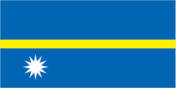
<strong>description:</strong> blue with a narrow horizontal gold stripe across the center and a large white 12-pointed star below the stripe on the left side<br><br><strong>meaning:</strong> blue stands for the Pacific Ocean; the star indicates the country's location in relation to the equator (the gold stripe), and the 12 points stand for the original tribes of Nauru; the star's white color represents phosphate, the basis of the island's wealth
The flag of Nauru has a dark blue field with a thin yellow horizontal band across the center and a large white twelve-pointed star beneath the horizontal band on the hoist side of the field.
- svg
- https://flagcdn.com/nr.svg
parliamentary republic
31 January 1968 (from the Australia-, NZ-, and UK-administered UN trusteeship)
has not submitted an ICJ jurisdiction declaration; accepts ICCt jurisdiction
ACP, ADB, AOSIS, C, FAO, G-77, ICAO, ICCt, IFAD, Interpol, IOC, IOM, ITU, OPCW, PIF, Sparteca, SPC, UN, UNCTAD, UNESCO, UPU, WHO, WMO
- Highest court(s)
- Supreme Court (consists of the chief justice and several justices)
- Judge selection and term of office
- judges appointed by the president to serve until age 65
- Note
- <strong>note:</strong> in 2017, the Nauruan Government revoked the 1976 High Court Appeals Act, which had allowed appeals beyond the Nauruan Supreme Court, and in 2018, the government formed its own appeals court
- Subordinate courts
- District Court, Family Court
mixed system of common law based on the English model and customary law
- Electoral system
- plurality/majority
- Expected date of next election
- October 2028
- Legislative structure
- unicameral
- Legislature name
- Parliament
- Most recent election date
- 10/11/2025
- Number of seats
- 19 (all directly elected)
- Percentage of women in chamber
- 10.5%
- Scope of elections
- Full renewal
- Term in office
- 3 years
blue, yellow, white
Independence Day, 31 January (1968)
frigatebird, calophyllum flower
Nauru does not have formal political parties; alliances within the government are often formed based on extended family ties
Monday
20 years of age; universal and compulsory
Yes
Economy
- coconuts, tropical fruits, pork, eggs, pork offal, pork fat, chicken, papayas, vegetables, cabbages (2023)
- note
- <b>note:</b> top ten agricultural products based on tonnage
- Expenditures
- $157.86 million (2020 est.)
- Note
- <b>note:</b> central government revenues (excluding grants) and expenditures converted to US dollars at average official exchange rate for year indicated
- Revenues
- $199.74 million (2020 est.)
- code
- AUD
- name
- Australian dollar (AUD) [$]
- $9.73 million
- Current account balance 2021
- $6.597 million (2021 est.)
- Current account balance 2022
- $2.966 million (2022 est.)
- Current account balance 2023
- $1.923 million (2023 est.)
- Note
- <b>note:</b> balance of payments - net trade and primary/secondary income in current dollars
upper-middle-income Pacific island country; phosphate resource exhaustion made island interior uninhabitable; licenses fishing rights; houses Australia’s Regional Processing Centre; former tax haven; largely dependent on foreign subsidies
- Currency
- Australian dollars (AUD) per US dollar -
- Exchange rates 2020
- 1.453 (2020 est.)
- Exchange rates 2021
- 1.331 (2021 est.)
- Exchange rates 2022
- 1.442 (2022 est.)
- Exchange rates 2023
- 1.505 (2023 est.)
- Exchange rates 2024
- 1.515 (2024 est.)
- $89.95 million
- Exports 2021
- $54.403 million (2021 est.)
- Exports 2022
- $78.383 million (2022 est.)
- Exports 2023
- $64.931 million (2023 est.)
- Note
- <b>note:</b> balance of payments - exports of goods and services in current dollars
- fish, phosphates (2023)
- note
- <strong>note:</strong> top export commodities based on value in dollars over $500,000
- Thailand 78%, Philippines 11%, NZ 5%, Japan 1%, Canada 1% (2023)
- note
- <b>note:</b> top five export partners based on percentage share of exports
- net inflows
- $-5,846,143
- $160.351 million (2024 est.)
- note
- <b>note:</b> data in current dollars at official exchange rate
$13,609
34.8 (2012)
$252.08 million
$20,400
- $179.7 million
- Imports 2021
- $141.185 million (2021 est.)
- Imports 2022
- $165.371 million (2022 est.)
- Imports 2023
- $150.193 million (2023 est.)
- Note
- <b>note:</b> balance of payments - imports of goods and services in current dollars
- ships, titanium ore, refined petroleum, plastic products, other foods (2023)
- note
- <b>note:</b> top five import commodities based on value in dollars
- Australia 50%, Japan 11%, Fiji 9%, Senegal 9%, China 9% (2023)
- note
- <b>note:</b> top five import partners based on percentage share of imports
phosphate mining, offshore banking, coconut products
- Inflation rate (consumer prices) 2020
- 1.8% (2020 est.)
- Inflation rate (consumer prices) 2021
- 2.4% (2021 est.)
- Inflation rate (consumer prices) 2022
- 2.6% (2022 est.)
- Note
- <strong>note:</strong> annual % change based on consumer prices
- Public debt 2016
- 65% of GDP (2016 est.)
- $169.32 million
- Note
- <b>note:</b> data in 2021 dollars
- Real GDP (purchasing power parity) 2022
- $147.026 million (2022 est.)
- Real GDP (purchasing power parity) 2023
- $147.976 million (2023 est.)
- Real GDP (purchasing power parity) 2024
- $150.581 million (2024 est.)
- 1.39%
- Note
- <b>note:</b> annual GDP % growth based on constant local currency
- Real GDP growth rate 2022
- 3% (2022 est.)
- Real GDP growth rate 2023
- 0.6% (2023 est.)
- Real GDP growth rate 2024
- 1.8% (2024 est.)
- $14,173
- Note
- <b>note:</b> data in 2021 dollars
- Real GDP per capita 2022
- $12,500 (2022 est.)
- Real GDP per capita 2023
- $12,500 (2023 est.)
- Real GDP per capita 2024
- $12,600 (2024 est.)
- $2.24 million
- Note
- <b>note:</b> personal transfers and compensation between resident and non-resident individuals/households/entities
- Remittances 2021
- 0.7% of GDP (2021 est.)
- Remittances 2022
- 0.6% of GDP (2022 est.)
- Remittances 2023
- 0.6% of GDP (2023 est.)
- 44.4% (of GDP) (2020 est.)
- note
- <b>note:</b> central government tax revenue as a % of GDP
Energy
- Consumption
- 37.893 million kWh (2023 est.)
- Installed generating capacity
- 19,000 kW (2023 est.)
- Transmission/distribution losses
- 3.922 million kWh (2023 est.)
- Electrification - total population
- 100% (2022 est.)
- Fossil fuels
- 88% of total installed capacity (2023 est.)
- hydroelectric
- 0%
- nuclear
- 0%
- renewable
- 9.82%
- Solar
- 12% of total installed capacity (2023 est.)
- Refined petroleum consumption
- 500 bbl/day (2023 est.)
1.9%
Communications
- per 100 inhabitants
- 10 per 100
- Subscriptions per 100 inhabitants
- 10 (2022 est.)
- Total
- 1,000 (2022 est.)
1 state-owned TV station broadcasting programs from New Zealand; 1 state-owned radio station, broadcasting on AM and FM, uses Australian and British programs (2019)
.nr
- Percent of population
- 82% (2020 est.)
+674
- Subscriptions per 100 inhabitants
- (2022 est.) less than 1
- Total subscriptions
- 0 (2019 est.) 0
- subscriptions per 100
- 87 per 100
- Subscriptions per 100 inhabitants
- 87 (2022 est.)
- Total subscriptions
- 10,300 (2022 est.)
Transportation
- passengers carried
- 39,104 passengers
- registered carrier departures
- 947 departures
1 (2025)
C2
Left
- By type
- other 6
- Total
- 6 (2023)
- Key ports
- Nauru
- Large
- 0
- Medium
- 0
- Ports with oil terminals
- 1
- Small
- 0
- Total ports
- 1 (2024)
- Very small
- 1
NAU
Military and Security
under the terms of a security deal signed in December 2024, Australia and Nauru agreed to “deepen and expand security cooperation” and “consult and consider” in the event of threats; Nauru pledged to seek Australia’s agreement before it signed any bilateral accords on maritime security, defense, and policing, and would receive Australian financial assistance in support of Nauru's police and security needs<br><br>Nauru has a "shiprider" agreement with the US, which allows local maritime law enforcement officers to embark on US Coast Guard (USCG) and US Navy (USN) vessels, including to board and search vessels suspected of violating laws or regulations within Nauru's designated exclusive economic zone (EEZ) or on the high seas; "shiprider" agreements also enable USCG personnel and USN vessels with embarked USCG law enforcement personnel to work with host nations to protect critical regional resources (2025)
no regular military forces; Nauru Police Force
Transnational Issues
- Refugees
- 95 (2024 est.)
Environment
- From petroleum and other liquids
- 86,000 metric tonnes of CO2 (2023 est.)
- Total emissions
- 86,000 metric tonnes of CO2 (2023 est.)
limited natural freshwater resources; effects of intensive phosphate mining that left the central 90% of Nauru a wasteland; air and water pollution from cadmium residue, phosphate dust, and other contaminants; rising sea levels
- Party to
- Biodiversity, Climate Change, Climate Change-Kyoto Protocol, Climate Change-Paris Agreement, Comprehensive Nuclear Test Ban, Desertification, Hazardous Wastes, Law of the Sea, Marine Dumping-London Convention, Ozone Layer Protection, Whaling
- Signed, but not ratified
- none of the selected agreements
7.4 micrograms per cubic meter (2019 est.)
0 % of total land area
10 % of total
10 million cubic meters (2022 est.)
- Municipal solid waste generated annually
- 6,200 tons (2024 est.)