Old Maps Online
Journey through centuries of cartography. Explore maps from the ancient world to the modern era, sourced from the world's great libraries.
Browse by Era
View all →Map Collection
24 maps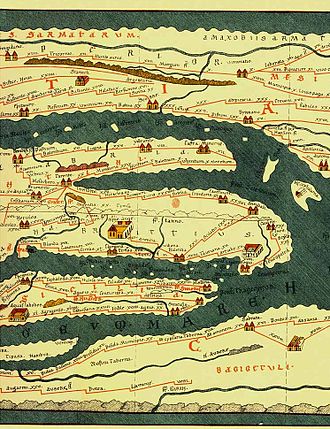
Tabula Peutingeriana
Tabula Peutingeriana, also known as Peutinger's Tabula, Peutinger tables and Peutinger Table, is an illustrated itinerar
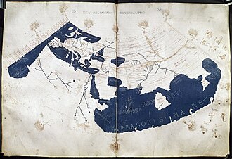
Ptolemy World Map
The Ptolemy world map is a map of the world known to Greco-Roman societies in the 2nd century. It is based on the descri
Tabula Rogeriana (1154)
Al-Idrisi's masterpiece of medieval cartography, one of the most advanced world maps of the medieval period.
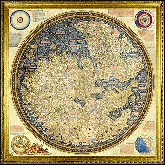
Fra Mauro Map
The Fra Mauro map is a map of the world made around 1450 by the Italian (Venetian) cartographer Fra Mauro, which is “c
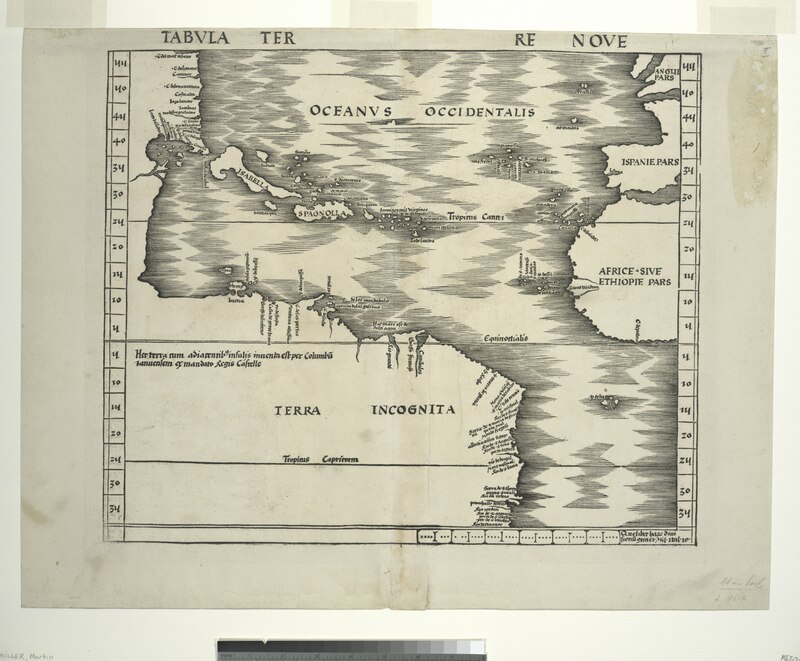
Waldseemüller Map (1507)
The first map to use the name "America," this groundbreaking map showed the New World as a separate continent.
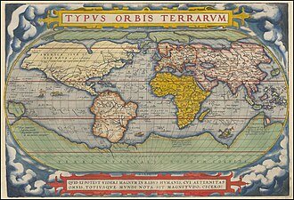
Mercator World Map (1569)
Gerardus Mercator's famous projection revolutionized navigation and remains one of the most widely used map projections.
Blaeu World Map (1664)
Joan Blaeu's stunning double-hemisphere world map from the Atlas Maior, considered one of the finest achievements of Dut
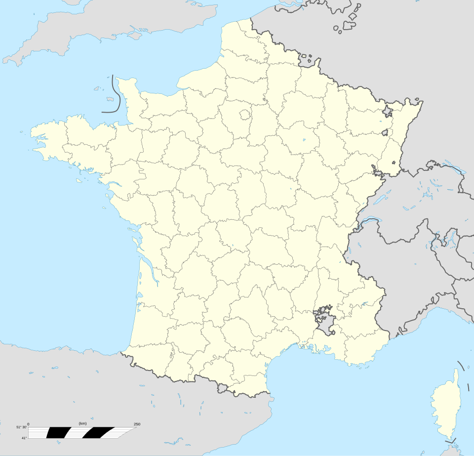
Cassini Map of France (1789)
The first topographic map of an entire country, based on triangulation surveys — a milestone in scientific cartography
Map of the British Empire (1886)
A striking imperial map showing the vast extent of the British Empire at its height, when it controlled a quarter of the
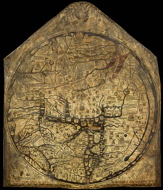
Hereford Mappa Mundi
The Hereford Mappa Mundi is the largest medieval map still known to exist, depicting the known world. It is a religious

Al-Idrisi World Map
The Nuzhat al-mushtāq fī ikhtirāq al-āfāq, commonly known in the West as the Tabula Rogeriana, is an atlas commissi
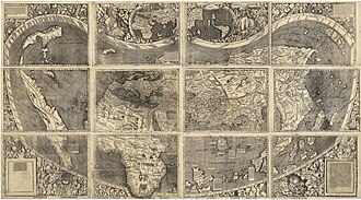
Waldseemüller Map (1507)
The Waldseemüller map or Universalis Cosmographia is a printed wall map of the world by the German cartographer Martin
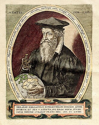
Mercator World Map (1569)
The Mercator world map of 1569 is titled Nova et Aucta Orbis Terrae Descriptio ad Usum Navigantium Emendate Accommodat
Ortelius Theatrum Orbis Terrarum
Theatrum Orbis Terrarum is considered to be the first true modern atlas. Written by Abraham Ortelius, strongly encourage

Cantino Planisphere
The Cantino planisphere or Cantino world map is a manuscript Portuguese world map preserved at the Biblioteca Estense in
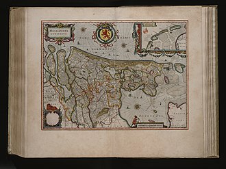
Blaeu Atlas Maior — World
The Atlas Maior is the final version of Joan Blaeu's atlas, published in Amsterdam between 1662 and 1672, in Latin, Fren
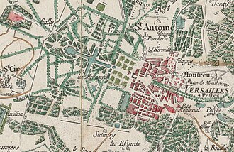
Cassini Map of France
The Cassini Map or Academy's Map is the first topographic and geometric map made of the Kingdom of France as a whole. It
Homann Map of Africa
Johann Baptist Homann was a German geographer and cartographer, who also made maps of the Americas. From the Nuremberg
Jaillot Map of North America
Alexis-Hubert Jaillot was a geographer and French cartographer, publisher at Paris, from the late 17th century and begin

Coronelli Globe Gores — Asia
Vincenzo Maria Coronelli was an Italian Franciscan friar, cosmographer, cartographer, publisher, and encyclopedist known
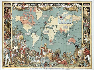
British Empire Map (1886)
The Imperial Federation was a series of proposals in the late 19th and early 20th centuries to create a federal union to

USGS Topographic Map
The United States Geological Survey (USGS), founded as the Geological Survey, is an agency of the United States Departme
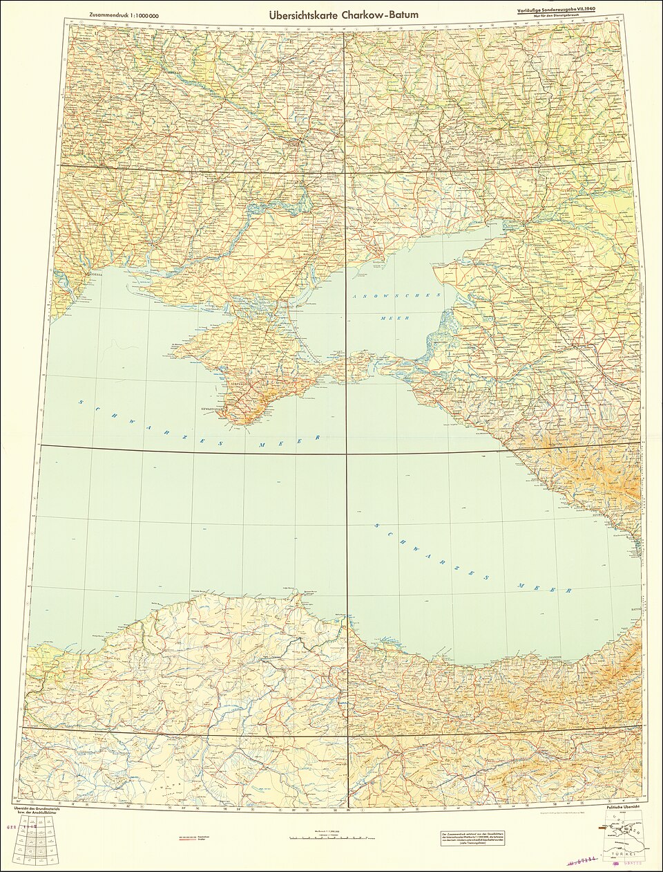
Soviet Military Map
The Soviet Union created the most comprehensive mapping of the entire world ever attempted, mapping foreign countries in
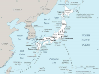
Japanese Map of Asia (1914)
The earliest known term used for maps in Japan is believed to be kata, which was probably in use until roughly the 8th c
Tabula Peutingeriana
ancientPtolemy World Map
ancientTabula Rogeriana (1154)
medievalFra Mauro Map
medievalWaldseemüller Map (1507)
renaissanceMercator World Map (1569)
renaissanceBlaeu World Map (1664)
early-modernCassini Map of France (1789)
early-modernMap of the British Empire (1886)
modernHereford Mappa Mundi
medievalAl-Idrisi World Map
medievalWaldseemüller Map (1507)
renaissanceMercator World Map (1569)
renaissanceOrtelius Theatrum Orbis Terrarum
renaissanceCantino Planisphere
renaissanceBlaeu Atlas Maior — World
early-modernCassini Map of France
early-modernHomann Map of Africa
early-modernJaillot Map of North America
early-modernCoronelli Globe Gores — Asia
early-modernBritish Empire Map (1886)
modernUSGS Topographic Map
modernSoviet Military Map
modernJapanese Map of Asia (1914)
modern
Tabula Peutingeriana, also known as Peutinger's Tabula, Peutinger tables and Peutinger Table, is an illustrated itinerarium showing the layout of the cursus publicus, the road network of the Roman Emp
View Details →The Ptolemy world map is a map of the world known to Greco-Roman societies in the 2nd century. It is based on the description contained in Ptolemy's book Geography, written c. 150. Based on an inscr
View Details →Al-Idrisi's masterpiece of medieval cartography, one of the most advanced world maps of the medieval period.
View Details →The Fra Mauro map is a map of the world made around 1450 by the Italian (Venetian) cartographer Fra Mauro, which is “considered the greatest memorial of medieval cartography." It is a circular plani
View Details →The first map to use the name "America," this groundbreaking map showed the New World as a separate continent.
View Details →Gerardus Mercator's famous projection revolutionized navigation and remains one of the most widely used map projections.
View Details →Joan Blaeu's stunning double-hemisphere world map from the Atlas Maior, considered one of the finest achievements of Dutch Golden Age cartography.
View Details →The first topographic map of an entire country, based on triangulation surveys — a milestone in scientific cartography.
View Details →A striking imperial map showing the vast extent of the British Empire at its height, when it controlled a quarter of the world's surface.
View Details →The Hereford Mappa Mundi is the largest medieval map still known to exist, depicting the known world. It is a religious rather than literal depiction, featuring heaven, hell and the path to salvation.
View Details →The Nuzhat al-mushtāq fī ikhtirāq al-āfāq, commonly known in the West as the Tabula Rogeriana, is an atlas commissioned by the Norman King Roger II in 1138 and completed by the Arab geographer Mu
View Details →The Waldseemüller map or Universalis Cosmographia is a printed wall map of the world by the German cartographer Martin Waldseemüller, originally published in April 1507. It is known as the first map
View Details →The Mercator world map of 1569 is titled Nova et Aucta Orbis Terrae Descriptio ad Usum Navigantium Emendate Accommodata. The title shows that Gerardus Mercator aimed to present contemporary knowledg
View Details →Theatrum Orbis Terrarum is considered to be the first true modern atlas. Written by Abraham Ortelius, strongly encouraged by Gillis Hooftman and originally printed on 20 May 1570 in Antwerp, it consis
View Details →The Cantino planisphere or Cantino world map is a manuscript Portuguese world map preserved at the Biblioteca Estense in Modena, Italy. It is named after Alberto Cantino, an agent for the Duke of Ferr
View Details →The Atlas Maior is the final version of Joan Blaeu's atlas, published in Amsterdam between 1662 and 1672, in Latin, French, Dutch, German and Spanish, containing 594 maps and around 3,000 pages of tex
View Details →The Cassini Map or Academy's Map is the first topographic and geometric map made of the Kingdom of France as a whole. It was compiled by the Cassini family, mainly César-François Cassini and his son
View Details →Johann Baptist Homann was a German geographer and cartographer, who also made maps of the Americas. From the Nuremberg publishing house of Johann Baptist Homann, one of the most influential map publi
View Details →Alexis-Hubert Jaillot was a geographer and French cartographer, publisher at Paris, from the late 17th century and beginning of the 18th century, in the service of King Louis XIV. A beautifully engra
View Details →Vincenzo Maria Coronelli was an Italian Franciscan friar, cosmographer, cartographer, publisher, and encyclopedist known in particular for his atlases and globes. He is considered one of the leading g
View Details →The Imperial Federation was a series of proposals in the late 19th and early 20th centuries to create a federal union to replace the existing British Empire, presenting it as an alternative to colonia
View Details →The United States Geological Survey (USGS), founded as the Geological Survey, is an agency of the United States Department of the Interior whose work spans the disciplines of biology, geography, geolo
View Details →The Soviet Union created the most comprehensive mapping of the entire world ever attempted, mapping foreign countries in extraordinary detail for military use.
View Details →The earliest known term used for maps in Japan is believed to be kata, which was probably in use until roughly the 8th century. During the Nara period, the term zu (図) came into use, but the term mo
View Details →Explore by Region
How It Works
Search & Discover
Explore maps by place, time period, or region. Find treasures from the Library of Congress, British Library, and more.
Examine in Detail
View maps in a full-screen lightbox. Zoom in to examine the intricate details of historical cartography.
Learn the Story
Every map has a story. Read about the cartographers, the era, and the historical context behind each creation.
Explore Modern Geography
See how the world looks today with interactive maps and country profiles on the World Factbook.
Our Partners
Trusted partner applications powering global data and insights