Introduction
<p>American sailor John HEARD discovered Heard Island in 1853 while fellow American William MCDONALD discovered the McDonald Islands the following year. Starting in 1855, sealers lived on the islands and harvested elephant seal oil; by the time the practice was ended in 1877, most of the islands’ seals were killed. The UK formally claimed the islands in 1910, and Australian explorer Douglas MAWSON visited Heard Island in 1929. In 1947, the UK transferred the islands to Australia for its Antarctica research, but Australia closed the research station on Heard Island in 1954 when it opened a new research station on the Antarctic continent. McDonald Island has been an active volcano since it emerged from dormancy in 1992, and the island doubled in size after an eruption in 1996. In 1997, the islands were named a UNESCO World Heritage site. Populated by a large number of bird species, seals, and penguins, the islands are primarily used for research, with limited fishing permitted in the surrounding waters.</p> <p style="margin: 0in; margin-bottom: .0001pt; line-height: 18.0pt; background: white;"> </p>
Geography
- Land
- 412 sq km
- Total
- 412 sq km
- Water
- 0 sq km
slightly more than two times the size of Washington, D.C.
antarctic
101.9 km
Antarctica
- Highest point
- Mawson Peak on Big Ben volcano 2,745 m
- Lowest point
- Indian Ocean 0 m
53 06 S, 72 31 E
Mawson Peak on Heard Island is the highest Australian mountain; at 2,745 m (9,006 ft), Mawson is taller than Mt. Kosciuszko in mainland Australia), and one of only two active volcanoes located in Australian territory; in 1992, McDonald Island, the other active volcano, broke its dormancy and began erupting; it has erupted several times since
- Total
- 0 km
- Agricultural land
- 0% (2011 est.)
- Other
- 100% (2018 est.)
No
islands in the Indian Ocean, about two-thirds of the way from Madagascar to Antarctica
- Google Maps
- https://goo.gl/maps/k5FBAiVaVyozuYeA7
- OpenStreetMap
- https://www.openstreetmap.org/relation/2177227
Antarctic Region
- Exclusive fishing zone
- 200 nm
- Territorial sea
- 12 nm
Mawson Peak, an active volcano, is on Heard Island
fish
Heard Island - 80% ice-covered, bleak and mountainous, dominated by a large massif (Big Ben) and an active volcano (Mawson Peak); McDonald Islands - small and rocky
- UTC+05:00
- number of time zones
- 1
People and Society
- languages
- English
- number of languages
- 1
- adjective
- Heard and McDonald Islander
- noun
- Heard and McDonald Islander
- Note
- <strong>note: </strong>limited scientific research and expeditions
- Total
- uninhabited
Government
- Abbreviation
- HIMI
- alternative spellings
- HM, Heard Island and McDonald Islands
- Conventional long form
- Territory of Heard Island and McDonald Islands
- Conventional short form
- Heard Island and McDonald Islands
- Etymology
- named after US Captain John HEARD, who sighted the island on 25 November 1853, and US Captain William McDONALD, who discovered the islands on 4 January 1854
- local long form (eng)
- Heard Island and McDonald Islands
territory of Australia; administered from Canberra by the Department of Agriculture, Water, and the Environment (Australian Antarctic Division)
- Embassy
- none (territory of Australia)
none (territory of Australia)
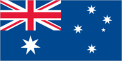
the flag of Australia is used
The flag of Heard Island and McDonald Islands has a dark blue field. It features the flag of the United Kingdom — the Union Jack — in the canton, beneath which is a large white seven-pointed star. A representation of the Southern Cross constellation, made up of one small five-pointed and four larger seven-pointed white stars, is situated on the fly side of the field.
- svg
- https://flagcdn.com/hm.svg
No
the laws of Australia apply
- Selected World Heritage Site locales
- Heard Island and McDonald Islands
- Total World Heritage Sites
- 1 (natural); note - excerpted from the Australia entry
Monday
No
Communications
.hm
Transportation
Right
2 (2025)
Military and Security
defense is the responsibility of Australia