Introduction
This uninhabited volcanic island in Antarctica is almost entirely covered by glaciers, making it difficult to approach. Bouvet Island is recognized as the most remote island on Earth because it is furthest from any other point of land (1,639 km from Antarctica). The island was named after the French naval officer who discovered it in 1739, although no country laid claim to it until 1825, when the British flag was raised. A few expeditions visited the island in the late 19th century. In 1929, the UK waived its claim in favor of Norway, which had occupied the island two years previously. In 1971, Norway designated Bouvet Island and the adjacent territorial waters as a nature reserve. Since 1977, Norway has run an automated meteorological station and studied foraging strategies and distribution of fur seals and penguins on the island. In 2006, an earthquake weakened the station's foundation, causing it to be blown out to sea in a winter storm. Norway erected a new research station in 2014 that can hold six people for periods of two to four months.
Geography
- Land
- 49 sq km
- Total
- 49 sq km
- Water
- 0 sq km
about 0.3 times the size of Washington, D.C.
antarctic
29.6 km
Antarctica
- Highest point
- Olavtoppen (Olav Peak) 780 m
- Lowest point
- South Atlantic Ocean 0 m
54 26 S, 3 24 E
almost entirely covered by glacial ice (93%); declared a nature reserve by Norway; the distance from Bouvet Island to Norway is 12,776 km, which is almost one-third the circumference of the earth
- Total
- 0 km
- Agricultural land
- 0% (2018 est.)
- Agricultural land: arable land
- arable land: 0% (2018 est.)
- Agricultural land: permanent crops
- permanent crops: 0% (2018 est.)
- Agricultural land: permanent pasture
- permanent pasture: 0% (2018 est.)
- Forest
- 0% (2018 est.)
- Other
- 100% (2018 est.)
No
island in the South Atlantic Ocean, southwest of the Cape of Good Hope (South Africa)
- Google Maps
- https://goo.gl/maps/7WRQAEKZb4uK36yi9
- OpenStreetMap
- https://www.openstreetmap.org/way/174996681
Antarctic Region
- Territorial sea
- 4 nm
occasional volcanism, rock slides; harsh climate, surrounded by pack ice in winter
none
volcanic; coast is mostly inaccessible
- UTC+01:00
- number of time zones
- 1
People and Society
- languages
- Norwegian
- number of languages
- 1
- adjective
- noun
- Note
- <strong>note: </strong>a small, seasonal research station is located in the northwest corner of Bouvet Island
- Total
- uninhabited
Government
- alternative spellings
- BV, Bouvetøya, Bouvet-øya
- Conventional long form
- none
- Conventional short form
- Bouvet Island
- Etymology
- named after the French naval officer Jean-Baptiste Charles BOUVET who discovered the island in 1739
- local long form (nor)
- Bouvetøya
- Note
- <strong>note:</strong> pronounced boo-vay i-land
territory of Norway; administered by the Polar Department of the Ministry of Justice and Oslo Police
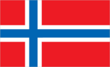
the flag of Norway is used
The flag of Bouvet Island has a red field with a large white-edged navy blue cross that extends to the edges of the field. The vertical part of this cross is offset towards the hoist side.
- svg
- https://flagcdn.com/bv.svg
No
the laws of Norway apply
Monday
No
Communications
.bv
+47
Transportation
Right