medieval
101 views
Fra Mauro Map
The Fra Mauro map is a map of the world made around 1450 by the Italian (Venetian) cartographer Fra Mauro, which is “considered the greatest memorial of medieval cartography." It is a circular planisphere drawn on parchment and set in a wooden frame that measures over two by two meters. Including Asia, the Indian Ocean, Africa, Europe, and the Atlantic, it is orientated with south at the top. The map is usually on display in the Biblioteca Nazionale Marciana in Venice in Italy. A large planis
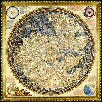
The Fra Mauro map is a map of the world made around 1450 by the Italian (Venetian) cartographer Fra Mauro, which is “considered the greatest memorial of medieval cartography." It is a circular planisphere drawn on parchment and set in a wooden frame that measures over two by two meters. Including Asia, the Indian Ocean, Africa, Europe, and the Atlantic, it is orientated with south at the top. The map is usually on display in the Biblioteca Nazionale Marciana in Venice in Italy.
A large planisphere made by the Venetian monk Fra Mauro. It is considered the greatest memorial of medieval cartography.
A large planisphere made by the Venetian monk Fra Mauro. It is considered the greatest memorial of medieval cartography.
Source: https://en.wikipedia.org/wiki/Fra_Mauro_map