medieval
133 views
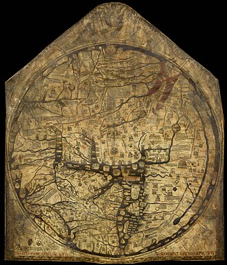
Hereford Mappa Mundi
The Hereford Mappa Mundi is the largest medieval map still known to exist, depicting the known world. It is a religious rather than literal depiction, featuring heaven, hell and the path to salvation. Dating from c. 1300 AD, the map is drawn in a form deriving from the T and O pattern. It is displayed at Hereford Cathedral in Hereford, England. The map was created as an intricate work of art rather than as a navigational tool. Sources for the information presented on the map include the Alexan
The Hereford Mappa Mundi is the largest medieval map still known to exist, depicting the known world. It is a religious rather than literal depiction, featuring heaven, hell and the path to salvation. Dating from c. 1300 AD, the map is drawn in a form deriving from the T and O pattern. It is displayed at Hereford Cathedral in Hereford, England. The map was created as an intricate work of art rather than as a navigational tool. Sources for the information presented on the map include the Alexander tradition, medieval bestiaries and legends of monstrous races, as well as the Bible.
The largest medieval map known to exist. Jerusalem is at the center, east is at the top, and it depicts Biblical events, mythology, and geographic features.
The largest medieval map known to exist. Jerusalem is at the center, east is at the top, and it depicts Biblical events, mythology, and geographic features.
Source: https://en.wikipedia.org/wiki/Hereford_Mappa_Mundi