modern
141 views
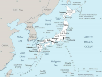
Japanese Map of Asia (1914)
The earliest known term used for maps in Japan is believed to be kata, which was probably in use until roughly the 8th century. During the Nara period, the term zu (図) came into use, but the term most widely used and associated with maps in pre-modern Japan is ezu. As the term implies, ezu were not necessarily geographically accurate depictions of physical landscape, as is generally associated with maps in modern times, but pictorial images, often including spiritual landscape in addition to p
The earliest known term used for maps in Japan is believed to be kata, which was probably in use until roughly the 8th century. During the Nara period, the term zu (図) came into use, but the term most widely used and associated with maps in pre-modern Japan is ezu. As the term implies, ezu were not necessarily geographically accurate depictions of physical landscape, as is generally associated with maps in modern times, but pictorial images, often including spiritual landscape in addition to physical geography. Ezu often focused on the conveyance of relative information as opposed to adherence to visible contour. For example, an ezu of a temple may include surrounding scenery and clouds to give an impression of nature, human figures to give a sense of how the depicted space is used, and a scale in which more important buildings may appear bigger than less important ones, regardless of actual physical size.
Japanese cartography evolved rapidly during the Meiji era, combining traditional East Asian mapping with modern Western surveying techniques.
Japanese cartography evolved rapidly during the Meiji era, combining traditional East Asian mapping with modern Western surveying techniques.
Source: https://en.wikipedia.org/wiki/Japanese_maps