early-modern
148 views
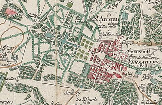
Cassini Map of France
The Cassini Map or Academy's Map is the first topographic and geometric map made of the Kingdom of France as a whole. It was compiled by the Cassini family, mainly César-François Cassini and his son Jean-Dominique Cassini in the 1700s. The first topographic map of an entire country based on extensive triangulation surveys. A landmark in scientific cartography.
The Cassini Map or Academy's Map is the first topographic and geometric map made of the Kingdom of France as a whole. It was compiled by the Cassini family, mainly César-François Cassini and his son Jean-Dominique Cassini in the 1700s.
The first topographic map of an entire country based on extensive triangulation surveys. A landmark in scientific cartography.
The first topographic map of an entire country based on extensive triangulation surveys. A landmark in scientific cartography.
Source: https://en.wikipedia.org/wiki/Cassini_map