2021 Edition
CIA World Factbook 2021 (factbook.json @ e0d5604b9e27)
Introduction
Background
Nauru was inhabited by Micronesian and Polynesian settlers by around 1000 B.C. and the island was divided in 12 clans. Nauru developed in relative isolation because ocean currents made landfall on the island difficult. As a result, the Nauruan language does not clearly resemble any other in the Pacific region. In 1798, British sea captain John FEARN became the first European to spot the island. By 1830, European whalers used Nauru as a supply stop, trading firearms for food. In 1878, a civil war erupted on the island, reducing the population by more than a third. Germany forcibly annexed Nauru in 1888 by holding the 12 chiefs under house arrest until they consented to the annexation. Germany banned alcohol, confiscated weapons, instituted strict dress codes, and brought in Christian missionaries to convert the population. Phosphate was discovered in 1900 and heavily mined, although Nauru and Nauruans earned about one tenth of one percent of the profits from the phosphate deposits.Australian forces captured Nauru from Germany during World War I, and in 1919, it was placed under a joint Australian-British-New Zealand mandate with Australian administration. Japan occupied Nauru during World War II and used its residents as forced labor elsewhere in the Pacific while destroying much of the infrastructure on the island. After the war, Nauru became a UN trust territory under Australian administration. Recognizing the phosphate stocks would eventually be depleted, in 1962, Australian Prime Minister Robert MENZIES offered to resettle all Nauruans on Curtis Island in Queensland, but Nauruans rejected that plan and opted for independence, which was achieved in 1968. In 1970, Nauru purchased the phosphate mining assets, and income from the mines made Nauruans among the richest people in the world. However, Nauru subsequently began a series of unwise investments in buildings, musical theater, and an airline. Nauru sued Australia in 1989 for the damage caused by mining when Australia administered the island. Widespread phosphate mining officially ceased in 2006.Nauru went nearly bankrupt by 2000 and tried to rebrand itself as an offshore banking haven, although it ended that practice in 2005. In 2001, Australia set up the Nauru Regional Processing Center (NRPC), an offshore refugee detention facility, paying Nauru per person at the center. The NRPC was closed in 2008 but reopened in 2012. The number of refugees has steadily declined since 2014, and the remaining people were moved to a hotel in Brisbane, Australia, in 2020, effectively shuttering the NRPC. In a bid for Russian humanitarian aid, in 2008, Nauru recognized the breakaway Georgian republics of Abkhazia and South Ossetia.
Geography
Area
- land
- 21 sq km
- total
- 21 sq km
- water
- 0 sq km
Area - comparative
about 0.1 times the size of Washington, DC
Climate
tropical with a monsoonal pattern; rainy season (November to February)
Coastline
30 km
Elevation
- highest point
- Command Ridge 70 m
- lowest point
- Pacific Ocean 0 m
Geographic coordinates
0 32 S, 166 55 E
Geography - note
Nauru is the third-smallest country in the world behind the Holy See (Vatican City) and Monaco; it is the smallest country in the Pacific Ocean, the smallest country outside Europe, the world's smallest island country, and the the world's smallest independent republic; situated just 53 km south of the Equator, Nauru is one of the three great phosphate rock islands in the Pacific Ocean - the others are Banaba (Ocean Island) in Kiribati and Makatea in French Polynesia
Irrigated land
0 sq km (2012)
Land boundaries
- total
- 0 km
Land use
- agricultural land
- 20% (2018 est.)
- agricultural land: arable land
- arable land: 0% (2018 est.)
- agricultural land: permanent crops
- permanent crops: 20% (2018 est.)
- agricultural land: permanent pasture
- permanent pasture: 0% (2018 est.)
- forest
- 0% (2018 est.)
- other
- 80% (2018 est.)
Location
Oceania, island in the South Pacific Ocean, south of the Marshall Islands
Map references
Oceania
Maritime claims
- contiguous zone
- 24 nm
- exclusive economic zone
- 200 nm
- territorial sea
- 12 nm
Natural hazards
periodic droughts
Natural resources
phosphates, fish
Population distribution
extensive phosphate mining made approximately 90% of the island unsuitable for farming; most people live in the fertile coastal areas, especially along the southwest coast
Terrain
sandy beach rises to fertile ring around raised coral reefs with phosphate plateau in center
People and Society
Age structure
- 0-14 years
- 30.87% (male 1,337/female 1,684)
- 15-24 years
- 16.35% (male 734/female 866)
- 25-54 years
- 42.57% (male 2,115/female 2,050)
- 55-64 years
- 6.72% (male 262/female 396)
- 65 years and over
- 3.48% (male 122/female 219) (2020 est.)
Birth rate
21.49 births/1,000 population (2021 est.)
Children under the age of 5 years underweight
NA
Contraceptive prevalence rate
NA
Current Health Expenditure
9.6% (2018)
Death rate
6.24 deaths/1,000 population (2021 est.)
Dependency ratios
- elderly dependency ratio
- NA
- potential support ratio
- NA
- total dependency ratio
- NA
- youth dependency ratio
- NA
Drinking water source
- improved: total
- total: 100% of population
- improved: urban
- urban: 100% of population
- unimproved: total
- total: 0% of population (2017 est.)
- unimproved: urban
- urban: 0% of population
Education expenditures
NA
Ethnic groups
Nauruan 88.9%, part Nauruan 6.6%, I-Kiribati 2%, other 2.5% (2007 est.)
HIV/AIDS - adult prevalence rate
NA
HIV/AIDS - deaths
NA
HIV/AIDS - people living with HIV/AIDS
NA
Infant mortality rate
- female
- 5.59 deaths/1,000 live births (2021 est.)
- male
- 10.25 deaths/1,000 live births
- total
- 7.96 deaths/1,000 live births
Languages
- Nauruan 93% (official, a distinct Pacific Island language), English 2% (widely understood, spoken, and used for most government and commercial purposes), other 5% (includes I-Kiribati 2% and Chinese 2%) (2011 est.)
- note
- note: data represent main language spoken at home; Nauruan is spoken by 95% of the population, English by 66%, and other languages by 12%
Life expectancy at birth
- female
- 71.3 years (2021 est.)
- male
- 64.06 years
- total population
- 67.62 years
Major infectious diseases
- degree of risk
- high (2020)
- food or waterborne diseases
- bacterial diarrhea
- vectorborne diseases
- malaria
Median age
- female
- 25.9 years (2020 est.)
- male
- 28.2 years
- total
- 27 years
Nationality
- adjective
- Nauruan
- noun
- Nauruan(s)
Net migration rate
-11.05 migrant(s)/1,000 population (2021 est.)
Obesity - adult prevalence rate
61% (2016)
Physicians density
1.35 physicians/1,000 population (2015)
Population
9,770 (July 2021 est.)
Population distribution
extensive phosphate mining made approximately 90% of the island unsuitable for farming; most people live in the fertile coastal areas, especially along the southwest coast
Population growth rate
0.42% (2021 est.)
Religions
Protestant 60.4% (includes Nauru Congregational 35.7%, Assembly of God 13%, Nauru Independent Church 9.5%, Baptist 1.5%, and Seventh Day Adventist 0.7%), Roman Catholic 33%, other 3.7%, none 1.8%, unspecified 1.1% (2011 est.)
Sanitation facility access
- improved: total
- total: 96.3% of population
- improved: urban
- urban: 96.3% of population
- unimproved: total
- total: 3.7% of population (2017 est.)
- unimproved: urban
- urban: 3.7% of population
Sex ratio
- 0-14 years
- 0.79 male(s)/female
- 15-24 years
- 0.85 male(s)/female
- 25-54 years
- 1.03 male(s)/female
- 55-64 years
- 0.66 male(s)/female
- 65 years and over
- 0.56 male(s)/female
- at birth
- 0.84 male(s)/female
- total population
- 0.88 male(s)/female (2020 est.)
Total fertility rate
2.65 children born/woman (2021 est.)
Unemployment, youth ages 15-24
- female
- 37.5% (2013)
- male
- 20.9%
- total
- 26.6%
Urbanization
- rate of urbanization
- 0.18% annual rate of change (2020-25 est.)
- urban population
- 100% of total population (2021)
Government
Administrative divisions
14 districts; Aiwo, Anabar, Anetan, Anibare, Baitsi, Boe, Buada, Denigomodu, Ewa, Ijuw, Meneng, Nibok, Uaboe, Yaren
Capital
- name
- no official capital; government offices in the Yaren District
- time difference
- UTC+12 (17 hours ahead of Washington, DC, during Standard Time)
Constitution
- amendments
- proposed by Parliament; passage requires two-thirds majority vote of Parliament; amendments to constitutional articles, such as the republican form of government, protection of fundamental rights and freedoms, the structure and authorities of the executive and legislative branches, also requires two-thirds majority of votes in a referendum; amended several times, last in 2018
- history
- effective 29 January 1968
Country name
- conventional long form
- Republic of Nauru
- conventional short form
- Nauru
- etymology
- the island name may derive from the Nauruan word "anaoero" meaning "I go to the beach"
- former
- Pleasant Island
- local long form
- Republic of Nauru
- local short form
- Nauru
Diplomatic representation from the US
- embassy
- the US does not have an embassy in Nauru; the US Ambassador to Fiji is accredited to Nauru
Diplomatic representation in the US
- chancery
- 800 2nd Avenue, Third Floor, New York, NY 10017
- chief of mission
- Ambassador Marlene Inemwin MOSES (since 13 March 2006)
- email address and website
- nauru@onecommonwealth.orghttps://www.un.int/nauru/
- FAX
- [1] (212) 937-0079
- telephone
- [1] (212) 937-0074
Executive branch
- cabinet
- Cabinet appointed by the president from among members of Parliament
- chief of state
- President Lionel AINGIMEA (since 27 August 2019); note - the president is both chief of state and head of government
- election results
- Lionel AINGIMEA elected president; Parliament vote - Lionel AINGIMEA (independent) 12, David ADEANG (Nauru First) 6
- elections/appointments
- president indirectly elected by Parliament (eligible for a second term); election last held on 27 August 2019 (next to be held in 2022)
- head of government
- President Lionel AINGIMEA (since 27 August 2019)
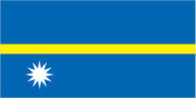
Flag description
blue with a narrow, horizontal, gold stripe across the center and a large white 12-pointed star below the stripe on the hoist side; blue stands for the Pacific Ocean, the star indicates the country's location in relation to the Equator (the gold stripe) and the 12 points symbolize the 12 original tribes of Nauru; the star's white color represents phosphate, the basis of the island's wealth
Government type
parliamentary republic
Independence
31 January 1968 (from the Australia-, NZ-, and UK-administered UN trusteeship)
International law organization participation
has not submitted an ICJ jurisdiction declaration; accepts ICCt jurisdiction
International organization participation
ACP, ADB, AOSIS, C, FAO, G-77, ICAO, ICCt, IFAD, Interpol, IOC, IOM, ITU, OPCW, PIF, Sparteca, SPC, UN, UNCTAD, UNESCO, UPU, WHO
Judicial branch
- highest courts
- Supreme Court (consists of the chief justice and several justices); note - in late 2017, the Nauruan Government revoked the 1976 High Court Appeals Act, which had allowed appeals beyond the Nauruan Supreme Court, and in early 2018, the government formed its own appeals court
- judge selection and term of office
- judges appointed by the president to serve until age 65
- subordinate courts
- District Court, Family Court
Legal system
mixed legal system of common law based on the English model and customary law
Legislative branch
- description
- unicameral parliament (19 seats; members directly elected in multi-seat constituencies by majority vote using the "Dowdall" counting system by which voters rank candidates on their ballots; members serve 3-year terms)
- election results
- percent of vote - NA; seats - independent 19; composition - men 17, women 2, percent of women 10.5%
- elections
- last held on 24 August 2019 (next to be held in 2022)
National anthem
- lyrics/music
- Margaret HENDRIE/Laurence Henry HICKS
- name
- "Nauru Bwiema" (Song of Nauru)
- note
- note: adopted 1968
National holiday
Independence Day, 31 January (1968)
National symbol(s)
frigatebird, calophyllum flower; national colors: blue, yellow, white
Political parties and leaders
Nauru First (Naoero Amo) Party [David ADEANG]
Suffrage
20 years of age; universal and compulsory
Economy
Agricultural products
coconuts, tropical fruit, vegetables, pork, eggs, pig offals, pig fat, poultry, papayas, cabbages
Budget
- expenditures
- 113.4 million (2017 est.)
- revenues
- 103 million (2017 est.)
Budget surplus (+) or deficit (-)
-9.2% (of GDP) (2017 est.)
Current account balance
- Current account balance 2016
- $2 million (2016 est.)
- Current account balance 2017
- $5 million (2017 est.)
Debt - external
- Debt - external 2004
- $33.3 million (2004 est.)
Economic overview
Revenues of this tiny island - a coral atoll with a land area of 21 square kilometers - traditionally have come from exports of phosphates. Few other resources exist, with most necessities being imported, mainly from Australia, its former occupier and later major source of support. Primary reserves of phosphates were exhausted and mining ceased in 2006, but mining of a deeper layer of "secondary phosphate" in the interior of the island began the following year. The secondary phosphate deposits may last another 30 years. Earnings from Nauru’s export of phosphate remains an important source of income. Few comprehensive statistics on the Nauru economy exist; estimates of Nauru's GDP vary widely.The rehabilitation of mined land and the replacement of income from phosphates are serious long-term problems. In anticipation of the exhaustion of Nauru's phosphate deposits, substantial amounts of phosphate income were invested in trust funds to help cushion the transition and provide for Nauru's economic future.Although revenue sources for government are limited, the opening of the Australian Regional Processing Center for asylum seekers since 2012 has sparked growth in the economy. Revenue derived from fishing licenses under the "vessel day scheme" has also boosted government income. Housing, hospitals, and other capital plant are deteriorating. The cost to Australia of keeping the Nauruan government and economy afloat continues to climb.
Exchange rates
- currency
- Australian dollars (AUD) per US dollar -
- Exchange rates 2013
- 1.1094 (2013 est.)
- Exchange rates 2014
- 1.3291 (2014 est.)
- Exchange rates 2015
- 1.3452 (2015 est.)
- Exchange rates 2016
- 1.3452 (2016 est.)
- Exchange rates 2017
- 1.311 (2017 est.)
Exports
- Exports 2012
- $110.3 million (2012 est.)
- Exports 2018
- $30 million note: data are in current year dollars (2018 est.)
Exports - commodities
fish, calcium phosphates, low-voltage protection equipment, air conditioners, leather apparel (2019)
Exports - partners
Thailand 34%, Australia 16%, United States 13%, South Korea 10%, Philippines 9%, Japan 7%, France 5% (2019)
Fiscal year
1 July - 30 June
GDP - composition, by end use
- exports of goods and services
- 11.2% (2016 est.)
- government consumption
- 37.6% (2016 est.)
- household consumption
- 98% (2016 est.)
- imports of goods and services
- -89.1% (2016 est.)
- investment in fixed capital
- 42.2% (2016 est.)
GDP - composition, by sector of origin
- agriculture
- 6.1% (2009 est.)
- industry
- 33% (2009 est.)
- services
- 60.8% (2009 est.)
GDP (official exchange rate)
$114 million (2017 est.)
Household income or consumption by percentage share
- highest 10%
- NA
- lowest 10%
- NA
Imports
- Imports 2016
- $64.9 million (2016 est.)
- Imports 2018
- $90 million note: data are in current year dollars (2018 est.)
Imports - commodities
refined petroleum, construction vehicles, tug boats, poultry meats, cars (2019)
Imports - partners
Taiwan 52%, Australia 28% (2019)
Industrial production growth rate
NA
Industries
phosphate mining, offshore banking, coconut products
Inflation rate (consumer prices)
- Inflation rate (consumer prices) 2016
- 8.2% (2016 est.)
- Inflation rate (consumer prices) 2017
- 5.1% (2017 est.)
Labor force
NA
Labor force - by occupation
note: most of the labor force is employed in phosphate mining, public administration, education, and transportation
Population below poverty line
NA
Public debt
- Public debt 2016
- 65% of GDP (2016 est.)
- Public debt 2017
- 62% of GDP (2017 est.)
Real GDP (purchasing power parity)
- note
- note: data are in 2015 dollars
- Real GDP (purchasing power parity) 2017
- $137 million (2017 est.)
- Real GDP (purchasing power parity) 2018
- $150 million note: data are in 2017 dollars (2018 est.)
- Real GDP (purchasing power parity) 2019
- $150 million note: data are in 2017 dollars (2019 est.)
Real GDP growth rate
- Real GDP growth rate 2015
- 2.8% (2015 est.)
- Real GDP growth rate 2016
- 10.4% (2016 est.)
- Real GDP growth rate 2017
- 4% (2017 est.)
Real GDP per capita
- note
- note: data are in 2015 US dollars
- Real GDP per capita 2017
- $10,667 (2017 est.)
- Real GDP per capita 2018
- $13,600 note: data are in 2017 dollars (2018 est.)
- Real GDP per capita 2019
- $13,500 note: data are in 2017 dollars (2019 est.)
Taxes and other revenues
90.3% (of GDP) (2017 est.)
Unemployment rate
- Unemployment rate 2004
- 90% (2004 est.)
- Unemployment rate 2011
- 23% (2011 est.)
Unemployment, youth ages 15-24
- female
- 37.5% (2013)
- male
- 20.9%
- total
- 26.6%
Energy
Crude oil - exports
0 bbl/day (2015 est.)
Crude oil - imports
0 bbl/day (2015 est.)
Crude oil - production
0 bbl/day (2018 est.)
Crude oil - proved reserves
0 bbl (1 January 2018 est.)
Electricity - consumption
22.32 million kWh (2016 est.)
Electricity - exports
0 kWh (2016 est.)
Electricity - from fossil fuels
86% of total installed capacity (2016 est.)
Electricity - from hydroelectric plants
0% of total installed capacity (2017 est.)
Electricity - from nuclear fuels
0% of total installed capacity (2017 est.)
Electricity - from other renewable sources
14% of total installed capacity (2017 est.)
Electricity - imports
0 kWh (2016 est.)
Electricity - installed generating capacity
7,000 kW (2016 est.)
Electricity - production
24 million kWh (2016 est.)
Electricity access
- electrification - rural areas
- 98.7% (2018)
- electrification - total population
- 99.8% (2018)
- electrification - urban areas
- 99.4% (2018)
Natural gas - consumption
0 cu m (2017 est.)
Natural gas - exports
0 cu m (2017 est.)
Natural gas - imports
0 cu m (2017 est.)
Natural gas - production
0 cu m (2017 est.)
Natural gas - proved reserves
0 cu m (1 January 2014 est.)
Refined petroleum products - consumption
470 bbl/day (2016 est.)
Refined petroleum products - exports
0 bbl/day (2015 est.)
Refined petroleum products - imports
449 bbl/day (2015 est.)
Refined petroleum products - production
0 bbl/day (2015 est.)
Communications
Broadband - fixed subscriptions
- subscriptions per 100 inhabitants
- 9.5 (2018)
- total
- 950 (2010)
Broadcast media
1 government-owned TV station broadcasting programs from New Zealand sent via satellite or on videotape; 1 government-owned radio station, broadcasting on AM and FM, utilizes Australian and British programs (2019)
Internet country code
.nr
Internet users
- percent of population
- 57% (2019 est.)
- total
- 6,771 (2021 est.)
Telecommunication systems
- domestic
- fixed-line 14 per 100 and mobile-cellular 95 per 100 (2019)
- general assessment
- adequate local and international radiotelephone communication provided via Australian facilities; geography is a challenge for the islands; there is a need to service the tourism sector and the South Pacific Islands economy; mobile technology is booming (2018)
- international
- country code - 674; satellite earth station - 1 Intelsat (Pacific Ocean)
- note
- note: the COVID-19 pandemic continues to have a significant impact on production and supply chains globally; since 2020, some aspects of the telecom sector have experienced downturn, particularly in mobile device production; many network operators delayed upgrades to infrastructure; progress towards 5G implementation was postponed or slowed in some countries; consumer spending on telecom services and devices was affected by large-scale job losses and the consequent restriction on disposable incomes; the crucial nature of telecom services as a tool for work and school from home became evident, and received some support from governments
Telephones - fixed lines
- subscriptions per 100 inhabitants
- 0 (2018 est.)
- total subscriptions
- 0 (2018 est.)
Telephones - mobile cellular
- subscriptions per 100 inhabitants
- 94.58 (2019 est.)
- total subscriptions
- 10,000 (2018)
Transportation
Airports
- total
- 1 (2013)
Airports - with paved runways
- 1,524 to 2,437 m
- 1 (2019)
- total
- 1
Civil aircraft registration country code prefix
C2
Merchant marine
- by type
- oil tanker 1, other 2 (2021)
- total
- 3
National air transport system
- annual freight traffic on registered air carriers
- 7.94 million mt-km (2018)
- annual passenger traffic on registered air carriers
- 45,457 (2018)
- inventory of registered aircraft operated by air carriers
- 5
- number of registered air carriers
- 1 (2020)
Ports and terminals
- major seaport(s)
- Nauru
Roadways
- paved
- 24 km (2002)
- total
- 30 km (2002)
- unpaved
- 6 km (2002)
Military and Security
Military - note
Nauru maintains no defense forces; under an informal agreement, defense is the responsibility of Australia
Military and security forces
no regular military forces; the police force, under the Minister for Police and Emergency Services, maintains internal security and, as necessary, external security
Transnational Issues
Disputes - international
none
Refugees and internally displaced persons
- stateless persons
- 140 (2020)
Environment
Air pollutants
- carbon dioxide emissions
- 0.05 megatons (2016 est.)
- methane emissions
- 0.01 megatons (2020 est.)
- particulate matter emissions
- 12.53 micrograms per cubic meter (2016 est.)
Climate
tropical with a monsoonal pattern; rainy season (November to February)
Environment - current issues
limited natural freshwater resources, roof storage tanks that collect rainwater and desalination plants provide water; a century of intensive phosphate mining beginning in 1906 left the central 90% of Nauru a wasteland; cadmium residue, phosphate dust, and other contaminants have caused air and water pollution with negative impacts on health; climate change has brought on rising sea levels and inland water shortages
Environment - international agreements
- party to
- Biodiversity, Climate Change, Climate Change-Kyoto Protocol, Climate Change-Paris Agreement, Comprehensive Nuclear Test Ban, Desertification, Hazardous Wastes, Law of the Sea, Marine Dumping-London Convention, Ozone Layer Protection, Whaling
- signed, but not ratified
- none of the selected agreements
Land use
- agricultural land
- 20% (2018 est.)
- agricultural land: arable land
- arable land: 0% (2018 est.)
- agricultural land: permanent crops
- permanent crops: 20% (2018 est.)
- agricultural land: permanent pasture
- permanent pasture: 0% (2018 est.)
- forest
- 0% (2018 est.)
- other
- 80% (2018 est.)
Major infectious diseases
- degree of risk
- high (2020)
- food or waterborne diseases
- bacterial diarrhea
- vectorborne diseases
- malaria
Revenue from forest resources
- forest revenues
- 0% of GDP (2018 est.)
Total renewable water resources
10 million cubic meters (2017 est.)
Urbanization
- rate of urbanization
- 0.18% annual rate of change (2020-25 est.)
- urban population
- 100% of total population (2021)
Waste and recycling
- municipal solid waste generated annually
- 6,192 tons (2016 est.)