1994 Edition
CIA World Factbook 1994 (Project Gutenberg)
Introduction
Administrative divisions
9 districts and 3 dependencies*; Agalega Islands*, Black River, Cargados Carajos*, Flacq, Grand Port, Moka, Pamplemousses, Plaines Wilhems, Port Louis, Riviere du Rempart, Rodrigues*, Savanne
Agriculture
accounts for 10% of GDP; about 90% of cultivated land in sugarcane; other products - tea, corn, potatoes, bananas, pulses, cattle, goats, fish; net food importer, especially rice and fish
Airports
total: 5 usable: 4 with permanent-surface runways: 2 with runways over 3,659 m: with runways 2,440-3,659 m: 1 with runways 1,220-2,439 m:
Area
total area: 1,860 sq km land area: 1,850 sq km comparative area: slightly less than 10.5 times the size of Washington, DC note: includes Agalega Islands, Cargados Carajos Shoals (Saint Brandon), and Rodrigues
Birth rate
19.28 births/1,000 population (1994 est.)
Branches
National Police Force, including the paramilitary Special Mobile Force (SMF), Special Support Units (SSU), and National Coast Guard
Budget
revenues: $557 million expenditures: $607 million, including capital expenditures of $111 million (1990 est.)
Capital
Port Louis
Climate
tropical modified by southeast trade winds; warm, dry winter (May to November); hot, wet, humid summer (November to May)
Coastline
177 km
Constitution
12 March 1968; amended 12 March 1992
Currency
1 Mauritian rupee (MauR) = 100 cents
Death rate
6.41 deaths/1,000 population (1994 est.)
Defense expenditures
exchange rate conversion - $5 million, 0.2% of GDP (FY89)
Digraph
MP
Diplomatic representation in US
chief of mission: Ambassador Anund NEEWOOR chancery: Suite 441, 4301 Connecticut Avenue NW, Washington, DC 20008 telephone: (202) 244-1491 or 1492
Economic aid
recipient: US commitments, including Ex-Im (FY70-89), $76 million; Western (non-US) countries (1970-89), $709 million; Communist countries (1970-89), $54 million
Electricity
capacity: 235,000 kW production: 630 million kWh consumption per capita: 570 kWh (1992)
Environment
current issues: water pollution natural hazards: subject to cyclones (November to April); almost completely surrounded by reefs international agreements: party to - Biodiversity, Climate Change, Endangered Species, Environmental Modification, Hazardous Wastes, Marine Life Conservation, Nuclear Test Ban, Ozone Layer Protection, Whaling; signed, but not ratified - Law of the Sea
Ethnic divisions
Indo-Mauritian 68%, Creole 27%, Sino-Mauritian 3%, Franco-Mauritian 2%
Exchange rates
Mauritian rupees (MauRs) per US$1 - 18.696 (January 1994), 17.648 (1993), 15.563 (1992), 15.652 (1991), 14.839 (1990), 15.250 (1989)
Executive branch
chief of state: President Cassam UTEEM (since 1 July 1992); Vice President Rabindranath GHURBURRON (since 1 July 1992) head of government: Prime Minister Sir Anerood JUGNAUTH (since 12 June 1982); Deputy Prime Minister Prem NABABSING (since 26 September 1990) cabinet: Council of Ministers; appointed by the president on recommendation of the prime minister
Exports
$1.32 billion (f.o.b., 1992 est.) commodities: textiles 44%, sugar 40%, light manufactures 10% partners: EC and US have preferential treatment, EU 77%, US 15%
External debt
$991 million (1992 est.)
FAX
- (202) 966-0983
- [230] 208-9534
Fiscal year
1 July - 30 June
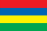
Flag
four equal horizontal bands of red (top), blue, yellow, and green
Highways
total: 1,800 km paved: 1,640 km unpaved: earth 160 km
Illicit drugs
illicit producer of cannabis for the international drug trade; heroin consumption and transshipment are growing problems
Imports
$1.63 billion (f.o.b., 1992 est.) commodities: manufactured goods 50%, capital equipment 17%, foodstuffs 13%, petroleum products 8%, chemicals 7% partners: EC, US, South Africa, Japan
Independence
12 March 1968 (from UK)
Industrial production
growth rate 7% (1990); accounts for 25% of GDP
Industries
food processing (largely sugar milling), textiles, wearing apparel, chemicals, metal products, transport equipment, nonelectrical machinery, tourism
Infant mortality rate
18.4 deaths/1,000 live births (1994 est.)
Inflation rate (consumer prices)
4.6% (1992 est.)
International disputes
claims UK-administered Chagos Archipelago, which includes the island of Diego Garcia in UK-administered British Indian Ocean Territory; claims French-administered Tromelin Island
Irrigated land
170 sq km (1989 est.)
Judicial branch
Supreme Court
Labor force
335,000 by occupation: government services 29%, agriculture and fishing 27%, manufacturing 22%, other 22% note: 43% of population of working age (1985)
Land boundaries
0 km
Land use
arable land: 54% permanent crops: 4% meadows and pastures: 4% forest and woodland: 31% other: 7%
Languages
English (official), Creole, French, Hindi, Urdu, Hakka, Bojpoori
Legal system
based on French civil law system with elements of English common law in certain areas
Legislative Assembly
elections last held on 15 September 1991 (next to be held by 15 September 1996); results - MSM/MMM 53%, MLP/PMSD 38%; seats - (70 total, 62 elected) MSM/MMM alliance 59 (MSM 29, MMM 26, OPR 2, MTD 2); MLP/PMSD 3
Legislative branch
unicameral
Life expectancy at birth
total population: 70.54 years male: 66.62 years female: 74.63 years (1994 est.)
Literacy
age 15 and over can read and write (1990) total population: 80% male: 85% female: 75%
Location
Southern Africa, in the western Indian Ocean, 900 km east of Madagascar
Manpower availability
males age 15-49 316,975; fit for military service 161,634
Map references
Africa, Standard Time Zones of the World
Maritime claims
contiguous zone: 24 nm continental shelf: 200 nm or the edge of continental margin exclusive economic zone: 200 nm territorial sea: 12 nm
Member of
ACCT, ACP, AfDB, C, CCC, ECA, FAO, G-77, GATT, IAEA, IBRD, ICAO, ICFTU, IDA, IFAD, IFC, ILO, IMF, INMARSAT, IMO, INTELSAT, INTERPOL, IOC, ISO (correspondent), ITU, LORCS, NAM, OAU, PCA, UN, UNCTAD, UNESCO, UNIDO, UPU, WCL, WFTU, WHO, WIPO, WMO, WTO
Merchant marine
14 ships (1,000 GRT or over) totaling 162,387 GRT/260,552 DWT, bulk 6, cargo 7, liquefied gas 1
Names
conventional long form: Republic of Mauritius conventional short form: Mauritius
National holiday
Independence Day, 12 March (1968)
National product
GDP - purchasing power equivalent - $8.6 billion (1993 est.)
National product per capita
$7,800 (1993 est.)
National product real growth rate
6.3% (1992 est.)
Nationality
noun: Mauritian(s) adjective: Mauritian
Natural resources
arable land, fish
Net migration rate
-3.67 migrant(s)/1,000 population (1994 est.)
Other political or pressure groups
various labor unions
Overview
The economy is based on sugar, manufacturing (mainly textiles), and tourism. Sugarcane is grown on about 90% of the cultivated land area and accounts for 40% of export earnings. The government's development strategy centers on industrialization (with a view to exports), agricultural diversification, and tourism. Economic performance in 1992 was impressive, with 6% real growth and low unemployment.
Political parties and leaders
government coalition: Militant Socialist Movement (MSM), A. JUGNAUTH; Mauritian Militant Movement (MMM), Prem NABABSING (less 12 legislators under the leadership of Paul BERENGER, now voting with the opposition); Organization of the People of Rodrigues (OPR), Louis Serge CLAIR; Democratic Labor Movement (MTD), Anil BAICHOO opposition: Mauritian Labor Party (MLP), Navin RAMGOOLMAN; Socialist Workers Front, Sylvio MICHEL; Mauritian Social Democratic Party (PMSD), X. DUVAL; MMM-Berenger Faction, Paul BERENGER
Population
1,116,923 (July 1994 est.)
Population growth rate
0.92% (1994 est.)
Ports
Port Louis
Religions
Hindu 52%, Christian 28.3% (Roman Catholic 26%, Protestant 2.3%), Muslim 16.6%, other 3.1%
Suffrage
18 years of age; universal
Telecommunications
small system with good service utilizing primarily microwave radio relay; new microwave link to Reunion; high-frequency radio links to several countries; over 48,000 telephones; broadcast stations - 2 AM, no FM, 4 TV; 1 Indian Ocean INTELSAT earth station
Terrain
small coastal plain rising to discontinuous mountains encircling central plateau
Total fertility rate
2.22 children born/woman (1994 est.)
Type
parliamentary democracy
Unemployment rate
2.4% (1991 est.)
US diplomatic representation
chief of mission: Ambassador Leslie ALEXANDER embassy: 4th Floor, Rogers House, John Kennedy Street, Port Louis mailing address: use Embassy street address telephone: [230] 208-9763 through 208-9767