2007 Edition
CIA World Factbook 2007 (Project Gutenberg)
Introduction
Administrative divisions
9 provinces; Central, Copperbelt, Eastern, Luapula, Lusaka, Northern, North-Western, Southern, Western
Age structure
0-14 years: 46.3% (male 2,673,891/female 2,656,268) 15-64 years: 51.3% (male 2,925,910/female 2,969,324) 65 years and over: 2.4% (male 117,877/female 158,740) (2006 est.)
Agriculture - products
corn, sorghum, rice, peanuts, sunflower seed, vegetables, flowers, tobacco, cotton, sugarcane, cassava (tapioca), coffee; cattle, goats, pigs, poultry, milk, eggs, hides
Airports
111 (2006)
Airports - with paved runways
- over 3,047 m
- 1 2,438 to 3,047 m: 3 1,524 to 2,437 m: 4 914 to 1,523 m: 2 (2006)
- total
- 10
Airports - with unpaved runways
- total
- 101 2,438 to 3,047 m: 1 1,524 to 2,437 m: 4 914 to 1,523 m: 64
- under 914 m
- 32 (2006)
Area
- land
- 740,724 sq km
- total
- 752,614 sq km
- water
- 11,890 sq km
Area - comparative
slightly larger than Texas
Background
The territory of Northern Rhodesia was administered by the [British] South Africa Company from 1891 until it was taken over by the UK in 1923. During the 1920s and 1930s, advances in mining spurred development and immigration. The name was changed to Zambia upon independence in 1964. In the 1980s and 1990s, declining copper prices and a prolonged drought hurt the economy. Elections in 1991 brought an end to one-party rule, but the subsequent vote in 1996 saw blatant harassment of opposition parties. The election in 2001 was marked by administrative problems with three parties filing a legal petition challenging the election of ruling party candidate Levy MWANAWASA. The new president launched an anticorruption task force in 2002, but the government has yet to make a prosecution. The Zambian leader was reelected in 2006 in an election that was deemed free and fair. Geography Zambia
Birth rate
41 births/1,000 population (2006 est.)
Budget
- expenditures
- $2.99 billion; including capital expenditures of $NA (2006 est.)
- revenues
- $2.674 billion
Capital
- geographic coordinates
- 15 25 S, 28 17 E
- name
- Lusaka
- time difference
- UTC+2 (7 hours ahead of Washington, DC during Standard Time)
Climate
tropical; modified by altitude; rainy season (October to April)
Coastline
0 km (landlocked)
Constitution
24 August 1991; amended in 1996 to establish presidential term limits
Country name
- conventional long form
- Republic of Zambia
- conventional short form
- Zambia
- former
- Northern Rhodesia
Currency (code)
Zambian kwacha (ZMK)
Currency code
ZMK
Current account balance
$-165.4 million (2006 est.)
Death rate
19.93 deaths/1,000 population (2006 est.)
Debt - external
$4.397 billion (2006 est.)
Diplomatic representation from the US
- chief of mission
- Ambassador Carmen M. MARTINEZ
- embassy
- corner of Independence and United Nations Avenues, Lusaka
- mailing address
- P. O. Box 31617, Lusaka
- telephone
- [260] (1) 250-955
Diplomatic representation in the US
- chancery
- 2419 Massachusetts Avenue NW, Washington, DC 20008
- chief of mission
- Ambassador Inonge MBIKUSITA-LEWANIKA
- telephone
- [1] (202) 265-9717 through 9719
Disputes - international
in 2004 Zimbabwe dropped objections to plans between Botswana and Zambia to build a bridge over the Zambezi River, thereby de facto recognizing a short, but not clearly delimited, Botswana-Zambia boundary in the river
Distribution of family income - Gini index
52.6 (1998)
Economic aid - recipient
$640.6 million (2002)
Economy - overview
Despite progress in privatization and budgetary reform, Zambia's economic growth in 2005-06 remained somewhat below the 6%-7% per year needed to reduce poverty significantly. Privatization of government-owned copper mines relieved the government from covering mammoth losses generated by the industry and greatly improved the chances for copper mining to return to profitability and spur economic growth. Copper output has increased steadily since 2004, due to higher copper prices and the opening of new mines. The maize harvest was again good in 2005, helping boost GDP and agricultural exports. Cooperation continues with international bodies on programs to reduce poverty, including a new lending arrangement with the IMF in the second quarter of 2004. A tighter monetary policy will help cut inflation, but Zambia still has a serious problem with high public debt.
Electricity - consumption
6.692 billion kWh (2004)
Electricity - exports
2.975 billion kWh (2004)
Electricity - imports
403 million kWh (2004)
Electricity - production
9.962 billion kWh (2004)
Electricity - production by source
- fossil fuel
- 0.5%
- hydro
- 99.5%
- nuclear
- 0%
- other
- 0% (2001)
Elevation extremes
- highest point
- unnamed location in Mafinga Hills 2,301 m
- lowest point
- Zambezi river 329 m
Environment - current issues
air pollution and resulting acid rain in the mineral extraction and refining region; chemical runoff into watersheds; poaching seriously threatens rhinoceros, elephant, antelope, and large cat populations; deforestation; soil erosion; desertification; lack of adequate water treatment presents human health risks
Environment - international agreements
- party to
- Biodiversity, Climate Change, Desertification, Endangered Species, Hazardous Wastes, Law of the Sea, Ozone Layer Protection, Wetlands
- signed, but not ratified
- Climate Change-Kyoto Protocol
Ethnic groups
African 98.7%, European 1.1%, other 0.2%
Exchange rates
Zambian kwacha per US dollar - 3,371.98 (2006), 4,463.5 (2005), 4,778.9 (2004), 4,733.3 (2003), 4,398.6 (2002)
Executive branch
- cabinet
- Cabinet appointed by the president from among the members of the National Assembly
- chief of state
- President Levy MWANAWASA (since 2 January 2002); Vice President Rupiah BANDA (since 9 October 2006); note - the president is both the chief of state and head of government
- election results
- Levy MWANAWASA reelected president; percent of vote - Levy MWANAWASA 43.0%, Michael SATA 29.4%, Hakainde HICHILEMA 25.3%, Godfrey MIYANDA 1.6%, Winright NGONDO 0.8%
- elections
- president elected by popular vote for a five-year term (eligible for a second term); election last held 28 September 2006 (next to be held 2011); vice president appointed by the president
- head of government
- President Levy MWANAWASA (since 2 January 2002); Vice President Rupiah BANDA (since 9 October 2006); note - the president is both the chief of state and head of government
Exports
$3.928 billion f.o.b. (2006 est.)
Exports - commodities
copper/cobalt 64%, cobalt, electricity; tobacco, flowers, cotton
Exports - partners
Switzerland 28.7%, South Africa 18.6%, UK 14.4%, Democratic Republic of the Congo 5.4%, Tanzania 5.1%, Zimbabwe 4.1% (2005)
FAX
- [1] (202) 332-0826
- [260] (1) 252-225
Fiscal year
calendar year Communications Zambia
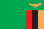
Flag description
green with a panel of three vertical bands of red (hoist side), black, and orange below a soaring orange eagle, on the outer edge of the flag Economy Zambia
GDP - composition by sector
- agriculture
- 19.9%
- industry
- 28.9%
- services
- 51.2% (2006 est.)
GDP - per capita (PPP)
$1,000 (2006 est.)
GDP - real growth rate
6% (2006 est.)
GDP (official exchange rate)
$5.806 billion (2006 est.)
GDP (purchasing power parity)
$11.51 billion (2006 est.)
Geographic coordinates
15 00 S, 30 00 E
Geography - note
landlocked; the Zambezi forms a natural riverine boundary with Zimbabwe People Zambia
Government type
republic
HIV/AIDS - adult prevalence rate
16.5% (2003 est.)
HIV/AIDS - deaths
89,000 (2003 est.)
HIV/AIDS - people living with HIV/AIDS
920,000 (2003 est.)
Household income or consumption by percentage share
- highest 10%
- 41% (1998)
- lowest 10%
- 1.1%
Illicit drugs
transshipment point for moderate amounts of methaqualone, small amounts of heroin, and cocaine bound for Southern Africa and possibly Europe; a poorly developed financial infrastructure coupled with a government commitment to combating money laundering make it an unattractive venue for money launderers This page was last updated on 8 February, 2007
Imports
$3.092 billion f.o.b. (2006 est.)
Imports - commodities
machinery, transportation equipment, petroleum products, electricity, fertilizer; foodstuffs, clothing
Imports - partners
South Africa 47.6%, UK 12.6%, Zimbabwe 4.3% (2005)
Independence
24 October 1964 (from UK)
Industrial production growth rate
10.1% (2006 est.)
Industries
copper mining and processing, construction, foodstuffs, beverages, chemicals, textiles, fertilizer, horticulture
Infant mortality rate
- female
- 79.37 deaths/1,000 live births (2006 est.)
- male
- 94.08 deaths/1,000 live births
- total
- 86.84 deaths/1,000 live births
Inflation rate (consumer prices)
8.8% (2006 est.)
International organization participation
ACP, AfDB, AU, C, COMESA, FAO, G-77, IAEA, IBRD, ICAO, ICCt, ICRM, IDA, IFAD, IFC, IFRCS, ILO, IMF, Interpol, IOC, IOM, IPU, ISO (correspondent), ITU, ITUC, MIGA, MONUC, NAM, OPCW, PCA, SADC, UN, UNCTAD, UNESCO, UNHCR, UNIDO, UNMEE, UNMIL, UNMIS, UNWTO, UPU, WCL, WCO, WHO, WIPO, WMO, WTO
Internet country code
.zm
Internet hosts
3,227 (2006)
Internet Service Providers (ISPs)
5 (2001)
Internet users
231,000 (2005) Transportation Zambia
Investment (gross fixed)
26.5% of GDP (2006 est.)
Irrigated land
1,560 sq km (2003)
Judicial branch
Supreme Court (the final court of appeal; justices are appointed by the president); High Court (has unlimited jurisdiction to hear civil and criminal cases)
Labor force
4.903 million (2006 est.)
Labor force - by occupation
- agriculture
- 85%
- industry
- 6%
- services
- 9%
Land boundaries
- border countries
- Angola 1,110 km, Democratic Republic of the Congo 1,930 km, Malawi 837 km, Mozambique 419 km, Namibia 233 km, Tanzania 338 km, Zimbabwe 797 km
- total
- 5,664 km
Land use
- arable land
- 6.99%
- other
- 92.97% (2005)
- permanent crops
- 0.04%
Languages
English (official), major vernaculars - Bemba, Kaonda, Lozi, Lunda, Luvale, Nyanja, Tonga, and about 70 other indigenous languages
Legal system
based on English common law and customary law; judicial review of legislative acts in an ad hoc constitutional council; has not accepted compulsory ICJ jurisdiction
Legislative branch
- unicameral National Assembly (158 seats; 150 members are elected by popular vote, eight members are appointed by the president, to serve five-year terms)
- election results
- percent of vote by party - NA; seats by party - MMD 72, PF 44, UDA 27, ULP 2, NDF 1, independents 2; seats not determined 2
- elections
- last held 28 September 2006 (next to be held in 2011)
Life expectancy at birth
- female
- 40.31 years (2006 est.)
- male
- 39.76 years
- total population
- 40.03 years
Literacy
- definition
- age 15 and over can read and write English
- female
- 74.8% (2003 est.) Government Zambia
- male
- 86.8%
- total population
- 80.6%
Location
Southern Africa, east of Angola
Major infectious diseases
- degree of risk
- very high
- food or waterborne diseases
- bacterial diarrhea, hepatitis A, and typhoid fever
- vectorborne diseases
- malaria and plague are high risks in some locations
- water contact disease
- schistosomiasis (2007)
Manpower available for military service
- females age 18-49
- 2,159,688 (2005 est.)
- males age 18-49
- 2,219,739
Manpower fit for military service
- females age 18-49
- 953,328 (2005 est.)
- males age 18-49
- 1,043,702
Map references
Africa
Maritime claims
none (landlocked)
Median age
- female
- 16.7 years (2006 est.)
- male
- 16.3 years
- total
- 16.5 years
Military expenditures - dollar figure
$121.7 million (2005 est.)
Military expenditures - percent of GDP
1.8% (2005 est.) Transnational Issues Zambia
Military service age and obligation
18 years of age (est.) (2004)
National holiday
Independence Day, 24 October (1964)
Nationality
- adjective
- Zambian
- noun
- Zambian(s)
Natural gas - consumption
0 cu m (2004 est.)
Natural gas - production
0 cu m (2004 est.)
Natural hazards
periodic drought, tropical storms (November to April)
Natural resources
copper, cobalt, zinc, lead, coal, emeralds, gold, silver, uranium, hydropower
Net migration rate
0 migrant(s)/1,000 population (2006 est.)
Oil - consumption
13,000 bbl/day (2004 est.)
Oil - exports
NA bbl/day (2001)
Oil - imports
NA bbl/day (2001)
Oil - production
140 bbl/day (2004 est.)
Pipelines
oil 771 km (2006)
Political parties and leaders
Agenda for Zambia or AZ [Inonge MBIKUSITA-LEWANIKA]; Forum for Democracy and Development or FDD [Christon TEMBO]; Heritage Party or HP [Godfrey MIYANDA]; Liberal Progressive Front or LPF [Roger CHONGWE, president]; Movement for Multiparty Democracy or MMD [Levy MWANAWASA, acting president]; National Leadership for Development or NLD [Yobert SHAMAPANDE]; National Party or NP [Dr. Sam CHIPUNGU]; Patriotic Front or PF [Michael SATA]; Social Democratic Party or SDP [Gwendoline KONIE]; United National Independence Party or UNIP [Francis NKHOMA, president]; United Party for National Development or UPND [Anderson MAZOKA]; Zambian Republican Party or ZRP [Benjamin MWILA]
Political pressure groups and leaders
NA
Population
- 11,502,010
- note
- estimates for this country explicitly take into account the effects of excess mortality due to AIDS; this can result in lower life expectancy, higher infant mortality and death rates, lower population and growth rates, and changes in the distribution of population by age and sex than would otherwise be expected (July 2006 est.)
Population below poverty line
86% (1993)
Population growth rate
2.11% (2006 est.)
Ports and terminals
Mpulungu Military Zambia
Public debt
65.7% of GDP (2006 est.)
Radio broadcast stations
AM 19, FM 5, shortwave 4 (2001)
Radios
1.2 million (2001)
Railways
- narrow gauge
- 2,173 km 1.067-m gauge
- note
- includes 891 km of the Tanzania-Zambia Railway Authority (TAZARA) (2005)
- total
- 2,173 km
Refugees and internally displaced persons
- refugees (country of origin)
- 75,468 (Angola), 61,243 (Democratic Republic of the Congo), 5,669 (Rwanda) (2006)
Religions
Christian 50%-75%, Muslim and Hindu 24%-49%, indigenous beliefs 1%
Reserves of foreign exchange and gold
$1.05 billion (2006 est.)
Roadways
- paved
- 20,117 km
- total
- 91,440 km
- unpaved
- 71,323 km (2001)
Sex ratio
- at birth
- 1.03 male(s)/female
- total population
- 0.99 male(s)/female (2006 est.)
- under 15 years
- 1.01 male(s)/female 15-64 years: 0.99 male(s)/female 65 years and over: 0.74 male(s)/female
Suffrage
18 years of age; universal
Telephone system
- domestic
- high-capacity microwave radio relay connects most larger towns and cities; several cellular telephone services in operation; Internet service is widely available; very small aperture terminal (VSAT) networks are operated by private firms
- general assessment
- facilities are aging but still among the best in Sub-Saharan Africa
- international
- country code - 260; satellite earth stations - 2 Intelsat (1 Indian Ocean and 1 Atlantic Ocean)
Telephones - main lines in use
94,700 (2005)
Telephones - mobile cellular
946,600 (2005)
Television broadcast stations
9 (2002)
Televisions
277,000 (1997)
Terrain
mostly high plateau with some hills and mountains
Total fertility rate
5.39 children born/woman (2006 est.)
Unemployment rate
50% (2000 est.)
Waterways
2,250 km (includes Lake Tanganyika and the Zambezi and Luapula rivers) (2005)
Zambian National Defense Force (ZNDF)
Army, Air Force, Police, National Service