1989 Edition
CIA World Factbook 1989 (Internet Archive)
Geography
Agriculture
cash crops — coffee, palm oil, rubber, quinine; food crops — cassava, bananas, root crops, corn
Aid
US commitments, including Ex-Im (FY70-88), $998 million; Western (nonUS) countries, ODA and OOF bilateral commitments (1970-87), $6.0 billion; OPEC bilateral aid (1979-89), $35 million; Communist countries (1970-88), $263 million
Budget
revenues $856 million; expenditures $2.3 billion, including capital expenditures of $655 million (1988)
Climate
tropical; modified by altitude; rainy season (October to April)
Coastline
none — landlocked
Comparative area
slightly larger than Texas
Currency
zaTre (plural — zai're); 1 zai're (Z) = 100 makuta
Disputes
quadripoint with Botswana, Namibia, and Zimbabwe is in disagreement; Tanzania-Zaire-Zambia tripoint in Lake Tanganyika may no longer be indefinite since it is reported that the indefinite section of the Zaire-Zambia boundary has been settled
Electricity
2,574,000 kW capacity; 5,550 million kWh produced, 160 kWh per capita (1989)
Environment
deforestation; soil erosion; desertification
Exchange rates
zai're (Z) per US$1— 465.000 (January 1989), 381.445 (1989), 187.070(1988), 112.403 (1987), 59.625 (1986), 49.873 (1985)
Exports
$2.2 billion (f.o.b., 1988); commodities— copper 37%, coffee 24%, diamonds 12%, cobalt, crude oil; partners — US, Belgium, France, FRG, Italy, UK, Japan
External debt
$8.6 billion (December 1989 est.)
Fiscal year
calendar year
GDP
$6.5 billion, per capita $195; real growth rate 2.8% (1988)
Illicit drugs
illicit producer of cannabis, mostly for domestic consumption
Imports
$1.9 billion (f.o.b., 1988); commodities— consumer goods, foodstuffs, mining and other machinery, transport equipment, fuels; partners — US, Belgium, France, FRG, Italy, Japan, UK
Industrial production
growth rate NA%
Industries
mining, mineral processing, consumer products (including textiles, footwear, and cigarettes), processed foods and beverages, cement, diamonds
Inflation rate (consumer prices)
82% (1988)
Land boundaries
5,664 km total; Angola 1,110 km, Malawi 837 km, Mozambique 419 km, Namibia 233 km, Tanzania 338 km, Zaire 1,930 km, Zimbabwe 797 km
Land use
7% arable land; NEGL% permanent crops; 47% meadows and pastures; 27% forest and woodland; 19% other; includes NEGL% irrigated
Maritime claims
none — landlocked
Natural resources
copper, cobalt, zinc, lead, coal, emeralds, gold, silver, uranium, hydropower potential
Note
landlocked
Terrain
mostly high plateau with some hills and mountains
Total area
752,610 km2; land area: 740,720 km2
Unemployment rate
NA%
People and Society
Birth rate
49 births/ 1,000 population (1990)
Death rate
12 deaths/ 1,000 population (1990)
Ethnic divisions
98.7% African, 1.1% European, 0.2% other
Infant mortality rate
80 deaths/ 1,000 live births (1990) Zambia (continued)
Labor force
2,455,000; 85% agriculture; 6% mining, manufacturing, and construction; 9% transport and services
Language
English (official); about 70 indigenous languages
Life expectancy at birth
55 years male, 58 years female (1990)
Literacy
75.7%
Nationality
noun — Zambian(s); adjective— Zambian
Net migration rate
—6 migrants/ 1,000 population (1990)
Organized labor
about 238,000 wage earners are unionized
Population
8,1 12,782 (July 1990), growth rate 3. 2% (1990)
Religion
50-75% Christian, 1% Muslim and Hindu, remainder indigenous beliefs
Total fertility rate
7.0 children born/ woman (1990)
Government
Administrative divisions
9 provinces; Central, Copperbelt, Eastern, Luapula, Lusaka, Northern, NorthWestern, Southern, Western
Capital
Lusaka
Communists
no Communist party
Constitution
25 August 1973
Diplomatic representation
Ambassador Paul J. F. LUSAKA; Chancery at 2419 Massachusetts Avenue NW, Washington DC 20008; telephone (202) 265-9717 through 9721; US — Ambassador Jeffrey DAVIDOW; Embassy at corner of Independence Avenue and United Nations Avenue, Lusaka (mailing address is P. O. Box 31617, Lusaka); telephone [2601]
Elections
President — last held 26 October 1988 (next to be held October 1993); results— President Kenneth Kaunda was reelected without opposition; National Assembly — last held 26 October 1988 (next to be held October 1993); results— UNIP is the only party; seats — (136 total, 125 elected) UNIP 125
Executive branch
president, prime minister, Cabinet
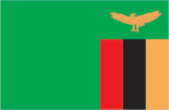
Flag
green with a panel of three vertical bands of red (hoist side), black, and orange below a soaring orange eagle, on the outer edge of the flag
Independence
24 October 1964 (from UK; formerly Northern Rhodesia)
Judicial branch
Supreme Court
Leaders
Chief of State — President Dr. Kenneth David KAUNDA (since 24 October 1964); Head of Government — Prime Minister Gen. Malimba MASHEKE (since 15 March 1989) Political parties and leaders: only party — United National Independence Party (UNIP), Kenneth Kaunda
Legal system
based on English common law and customary law; judicial review of legislative acts in an ad hoc constitutional council; has not accepted compulsory ICJ jurisdiction
Legislative branch
unicameral National Assembly
Long-form name
Republic of Zambia
Member of
ACP, AfDB, CCC, Commonwealth, FAO, G-77, GATT (de facto), IAEA, IBRD, ICAO, IDA, IEA, IFAD, IFC, ILO, ILZSG, IMF, INTELSAT, INTERPOL, IPU, ITU, NAM, OAU, SADCC, UN, UNESCO, UPU, WHO, WIPO, WMO, WTO
National holiday
Independence Day, 24 October (1964)
Suffrage
universal at age 18
Type
one-party state
Economy
Agriculture
accounts for 15% of GDP and 85% of labor force; crops — corn (food staple), sorghum, rice, peanuts, sunflower, tobacco, cotton, sugarcane, cassava; cattle, goats, beef, eggs produced; marginally self-sufficient in corn
Aid
US commitments, including Ex-Im (1970-88), $466 million; Western (non-US) countries, ODA and OOF bilateral commitments (1970-87), $4.2 billion; OPEC bilateral aid (1979-89), $60 million; Communist countries (1970-88), $533 million
Budget
revenues $570 million; expenditures $939 million, including capital expenditures of $36 million (1988 est.)
Currency
Zambian kwacha (plural — kwacha); 1 Zambian kwacha (ZK) = 100 ngwee
Electricity
1,900,000 kW capacity; 8,245 million kWh produced, 1 ,050 kWh per capita (1989)
Exchange rates
Zambian kwacha (ZK) per US$1— 21.7865 (January 1990), 12.9032 (1989), 8.2237 (1988), 8.8889 (1987), 7.3046 (1986), 2.7137 (1985)
Exports
$1,184 million (f.o.b., 1988); commodities — copper, zinc, cobalt, lead, tobacco; partners — EC, Japan, South Africa, US
External debt
$6.9 billion (December 1989)
Fiscal year
calendar year
GDP
$4.0 billion, per capita $530; real growth rate 6.7% (1988)
Imports
$687 million (c.i.f., 1988); commodities— machinery, transportation equipment, foodstuffs, fuels, manufactures; partners — EC, Japan, South Africa, US
Industrial production
growth rate NA% (1986)
Industries
copper mining and processing, transport, construction, foodstuffs, beverages, chemicals, textiles, and fertilizer
Inflation rate (consumer prices)
55.7% (1988)
Overview
Despite temporary growth in 1988, the economy has been in decline for more than a decade with falling imports and growing foreign debt. Economic difficulties stem from a sustained drop in copper production and ineffective economic policies. In 1988 real GDP stood only slightly higher than that of 10 years before, while an annual population growth of more than 3% has brought a decline in per capita GDP of 25% during the same period. A high inflation rate has also added to Zambia's economic woes in recent years.
Unemployment rate
NA%
Communications
Airports
- 312 total, 258 usable; 25 with permanent-surface runways; 1 with runways over 3,659 m; 6 with runways 2,4403,659 m; 71 with runways 1,220-2,439 m
- 121 total, 106 usable; 13 with permanent-surface runways; 1 with runways over 3,659 m; 4 with runways 2,4403,659 m; 22 with runways 1,220-2,439 m
Branches
- Army, Navy, Air Force, National Gendarmerie, Logistics Corps, Special Presidential Division
- Army, Air Force, Police, Paramilitary
Civil air
- 38 major transport aircraft
- 6 major transport aircraft
Defense expenditures
- $67 million (1988) Livingstone See region*! map VII
- NA
Highways
- 146,500 km total; 2,550 km bituminous, 46,450 km gravel and improved earth; remainder unimproved earth
- 36,370 km total; 6,500 km paved, 7,000 km crushed stone, gravel, or stabilized soil; 22,870 km improved and unimproved earth
Inland waterways
- 15,000 km including the Congo, its tributaries, and unconnected lakes
- 2,250 km, including Zambezi and Luapula Rivers, Lake Tanganyika
Merchant marine
4 ships (1,000 CRT or over) totaling 41,802 GRT/60,496 DWT; includes 1 passenger cargo, 3 cargo
Military manpower
- males 15-49, 7,970,619; 4,057,561 fit for military service
- males 1 5-49, 1,683,758; 883,283 fit for military service
Pipelines
- refined products 390 km
- 1,7241cm crude oil
Ports
- Matadi, Boma, Banana
- Mpulungu (lake port)
Railroads
- 5,254 km total; 3,968 km 1.067-meter gauge (851 km electrified); 125 km 1.000-meter gauge; 136 km 0.615-meter gauge; 1,025 km 0.600-meter gauge
- 1,266 km, all 1.067-meter gauge; 1 3 km double track
Telecommunications
- barely adequate wire and radio relay service; 31,200 telephones; stations— 10 AM, 4 FM, 18 TV; satellite earth stations — 1 Atlantic Ocean INTELSAT, 14 domestic Defense Forces
- facilities are among the best in Sub-Saharan Africa; high-capacity radio relay connects most larger towns and cities; 71,700 telephones; stations— 11 AM, 3 FM, 9 TV; satellite earth stations — 1 Indian Ocean INTELSAT and 1 Atlantic Ocean INTELSAT Defense Forces