2011 Edition
CIA World Factbook 2011 Archive (HTML)
Introduction
Background
The Gambia gained its independence from the UK in 1965. Geographically surrounded by Senegal, it formed a short-lived federation of Senegambia between 1982 and 1989. In 1991 the two nations signed a friendship and cooperation treaty, but tensions have flared up intermittently since then. Yahya JAMMEH led a military coup in 1994 that overthrew the president and banned political activity. A new constitution and presidential elections in 1996, followed by parliamentary balloting in 1997, completed a nominal return to civilian rule. JAMMEH has been elected president in all subsequent elections including most recently in late 2011.
Geography
Area
- 11,295 sq km 10,000 sq km 1,295 sq km
- total
- 11,295 sq km
- water
- 1,295 sq km
Area - comparative
slightly less than twice the size of Delaware
Climate
tropical; hot, rainy season (June to November); cooler, dry season (November to May)
Coastline
80 km
Elevation extremes
- Atlantic Ocean 0 m unnamed elevation 53 m
- highest point
- unnamed elevation 53 m
- lowest point
- Atlantic Ocean 0 m
Environment - current issues
deforestation; desertification; water-borne diseases prevalent
Environment - international agreements
- Biodiversity, Climate Change, Climate Change-Kyoto Protocol, Desertification, Endangered Species, Hazardous Wastes, Law of the Sea, Ozone Layer Protection, Ship Pollution, Wetlands, Whaling none of the selected agreements
- party to
- Biodiversity, Climate Change, Climate Change-Kyoto Protocol, Desertification, Endangered Species, Hazardous Wastes, Law of the Sea, Ozone Layer Protection, Ship Pollution, Wetlands, Whaling
- signed, but not ratified
- none of the selected agreements
Freshwater withdrawal (domestic/industrial/agricultural)
- 0.03 cu km/yr (23%/12%/65%) 20 cu m/yr (2000)
- per capita
- 20 cu m/yr (2000)
- total
- 0.03 cu km/yr (23%/12%/65%)
Geographic coordinates
13 28 N, 16 34 W
Geography - note
almost an enclave of Senegal; smallest country on the continent of Africa
Irrigated land
20 sq km (2008)
Land boundaries
- 740 km Senegal 740 km
- border countries
- Senegal 740 km
- total
- 740 km
Land use
- 27.88% 0.44% 71.68% (2005)
- arable land
- 27.88%
- other
- 71.68% (2005)
- permanent crops
- 0.44%
Location
Western Africa, bordering the North Atlantic Ocean and Senegal
Map references
Africa
Maritime claims
- 12 nm 18 nm 200 nm extent not specified
- contiguous zone
- 18 nm
- continental shelf
- extent not specified
- exclusive fishing zone
- 200 nm
- territorial sea
- 12 nm
Natural hazards
drought (rainfall has dropped by 30% in the last 30 years)
Natural resources
fish, clay, silica sand, titanium (rutile and ilmenite), tin, zircon
Terrain
flood plain of the Gambia River flanked by some low hills
Total renewable water resources
8 cu km (1982)
People and Society
Age structure
- 40% (male 360,732/female 358,440) 56.9% (male 501,946/female 520,826) 3.1% (male 26,645/female 29,271) (2011 est.)
- 0-14 years
- 40% (male 360,732/female 358,440)
- 15-64 years
- 56.9% (male 501,946/female 520,826)
- 65 years and over
- 3.1% (male 26,645/female 29,271) (2011 est.)
Birth rate
34.19 births/1,000 population (2011 est.)
Children under the age of 5 years underweight
15.8% (2006)
Death rate
7.65 deaths/1,000 population (July 2011 est.)
Drinking water source
- urban: 96% of population rural: 86% of population total: 92% of population urban: 4% of population rural: 14% of population total: 8% of population (2008)
- rural
- 14% of population
- total
- 8% of population (2008)
- urban
- 4% of population
Education expenditures
2% of GDP (2004)
Ethnic groups
African 99% (Mandinka 42%, Fula 18%, Wolof 16%, Jola 10%, Serahuli 9%, other 4%), non-African 1% (2003 census)
Health expenditures
10.1% of GDP (2009)
HIV/AIDS - adult prevalence rate
2% (2009 est.)
HIV/AIDS - deaths
fewer than 1,000 (2009 est.)
HIV/AIDS - people living with HIV/AIDS
18,000 (2009 est.)
Hospital bed density
1.13 beds/1,000 population (2009)
Infant mortality rate
- 71.67 deaths/1,000 live births 77.3 deaths/1,000 live births 65.87 deaths/1,000 live births (2011 est.)
- female
- 65.87 deaths/1,000 live births (2011 est.)
- total
- 71.67 deaths/1,000 live births
Languages
English (official), Mandinka, Wolof, Fula, other indigenous vernaculars
Life expectancy at birth
- 63.51 years 61.23 years 65.86 years (2011 est.)
- female
- 65.86 years (2011 est.)
- total population
- 63.51 years
Literacy
- age 15 and over can read and write 40.1% 47.8% 32.8% (2003 est.)
- definition
- age 15 and over can read and write
- female
- 32.8% (2003 est.)
- male
- 47.8%
- total population
- 40.1%
Major cities - population
BANJUL (capital) 436,000 (2009)
Major infectious diseases
- very high bacterial and protozoal diarrhea, hepatitis A, and typhoid fever malaria schistosomiasis meningococcal meningitis rabies (2009)
- animal contact disease
- rabies (2009)
- degree of risk
- very high
- food or waterborne diseases
- bacterial and protozoal diarrhea, hepatitis A, and typhoid fever
- respiratory disease
- meningococcal meningitis
- vectorborne diseases
- malaria
- water contact disease
- schistosomiasis
Maternal mortality rate
400 deaths/100,000 live births (2008)
Median age
- 19.4 years 19.2 years 19.7 years (2011 est.)
- female
- 19.7 years (2011 est.)
- male
- 19.2 years
- total
- 19.4 years
Nationality
- Gambian(s) Gambian
- adjective
- Gambian
- noun
- Gambian(s)
Net migration rate
-2.58 migrant(s)/1,000 population (2011 est.)
Physicians density
0.038 physicians/1,000 population (2008)
Population
1,797,860 (July 2011 est.)
Population growth rate
2.396% (2011 est.)
Religions
Muslim 90%, Christian 8%, indigenous beliefs 2%
Sanitation facility access
- urban: 68% of population rural: 65% of population total: 67% of population urban: 32% of population rural: 35% of population total: 33% of population (2008)
- rural
- 35% of population
- total
- 33% of population (2008)
- urban
- 32% of population
School life expectancy (primary to tertiary education)
- 9 years 9 years 9 years (2008)
- female
- 9 years (2008)
- male
- 9 years
- total
- 9 years
Sex ratio
- 1.03 male(s)/female 1.01 male(s)/female 0.98 male(s)/female 0.98 male(s)/female 1 male(s)/female (2011 est.)
- 15-64 years
- 0.98 male(s)/female
- 65 years and over
- 0.98 male(s)/female
- at birth
- 1.03 male(s)/female
- total population
- 1 male(s)/female (2011 est.)
- under 15 years
- 1.01 male(s)/female
Total fertility rate
4.23 children born/woman (2011 est.)
Urbanization
- 58% of total population (2010) 3.7% annual rate of change (2010-15 est.)
- rate of urbanization
- 3.7% annual rate of change (2010-15 est.)
- urban population
- 58% of total population (2010)
Government
Administrative divisions
5 divisions and 1 city*; Banjul*, Central River, Lower River, North Bank, Upper River, Western
Capital
- Banjul 13 27 N, 16 34 W UTC 0 (5 hours ahead of Washington, DC during Standard Time)
- geographic coordinates
- 13 27 N, 16 34 W
- name
- Banjul
- time difference
- UTC 0 (5 hours ahead of Washington, DC during Standard Time)
Constitution
approved by national referendum 8 August 1996; effective 16 January 1997
Country name
- Republic of The Gambia The Gambia
- conventional long form
- Republic of The Gambia
- conventional short form
- The Gambia
Diplomatic representation from the US
- Ambassador Pamela WHITE Kairaba Avenue, Fajara, Banjul P. M. B. No. 19, Banjul [220] 439-2856, 437-6169, 437-6170 [220] 439-2475
- chief of mission
- Ambassador Pamela WHITE
- embassy
- Kairaba Avenue, Fajara, Banjul
- FAX
- [220] 439-2475
- mailing address
- P. M. B. No. 19, Banjul
- telephone
- [220] 439-2856, 437-6169, 437-6170
Diplomatic representation in the US
- Ambassador Alieu Momodou NGUM Suite 240, Georgetown Plaza, 2233 Wisconsin Avenue NW, Washington, DC 20007 [1] (202) 785-1379, 1399, 1425 [1] (202) 785-1430
- chancery
- Suite 240, Georgetown Plaza, 2233 Wisconsin Avenue NW, Washington, DC 20007
- chief of mission
- Ambassador Alieu Momodou NGUM
- FAX
- [1] (202) 785-1430
- telephone
- [1] (202) 785-1379, 1399, 1425
Executive branch
- President Yahya JAMMEH (since 18 October 1996); note - from 1994 to 1996 he was chairman of the junta; Vice President Isatou NJIE-SAIDY (since 20 March 1997); note - the president is both the chief of state and head of government President Yahya JAMMEH (since 18 October 1996); Vice President Isatou NJIE-SAIDY (since 20 March 1997) Cabinet appointed by the president president elected by popular vote for a five-year term (no term limits); election last held on 24 November 2011 (next to be held in 2016) Yahya JAMMEH reelected president; percent of vote - Yahya JAMMEH 71.5%, Ousainou DARBOE 17.4%, Hamat BAH 11.1%
- cabinet
- Cabinet appointed by the president
- chief of state
- President Yahya JAMMEH (since 18 October 1996); note - from 1994 to 1996 he was chairman of the junta; Vice President Isatou NJIE-SAIDY (since 20 March 1997); note - the president is both the chief of state and head of government
- election results
- Yahya JAMMEH reelected president; percent of vote - Yahya JAMMEH 71.5%, Ousainou DARBOE 17.4%, Hamat BAH 11.1%
- elections
- president elected by popular vote for a five-year term (no term limits); election last held on 24 November 2011 (next to be held in 2016)
- head of government
- President Yahya JAMMEH (since 18 October 1996); Vice President Isatou NJIE-SAIDY (since 20 March 1997)
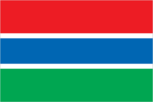
Flag description
three equal horizontal bands of red (top), blue with white edges, and green; red stands for the sun and the savannah, blue represents the Gambia River, and green symbolizes forests and agriculture; the white stripes denote unity and peace
Government type
republic
Independence
18 February 1965 (from the UK)
International law organization participation
accepts compulsory ICJ jurisdiction with reservations; accepts ICCt jurisdiction
International organization participation
ACP, AfDB, AU, C, ECOWAS, FAO, G-77, IBRD, ICAO, ICRM, IDA, IDB, IFAD, IFC, IFRCS, ILO, IMF, IMO, Interpol, IOC, IOM, IPU, ISO (correspondent), ITSO, ITU, ITUC, MIGA, NAM, OIC, OPCW, UN, UNAMID, UNCTAD, UNESCO, UNIDO, UNMIL, UNOCI, UNWTO, UPU, WCO, WFTU, WHO, WIPO, WMO, WTO
Judicial branch
Supreme Court
Legal system
mixed legal system of English common law, Islamic law, and customary law
Legislative branch
- unicameral National Assembly (53 seats; 48 members elected by popular vote, 5 appointed by the president; members to serve five-year terms) last held on 25 January 2007 (next to be held in 2012) percent of vote by party - NA; seats by party - APRC 47, UDP 4, NADD 1, independent 1
- election results
- percent of vote by party - NA; seats by party - APRC 47, UDP 4, NADD 1, independent 1
- elections
- last held on 25 January 2007 (next to be held in 2012)
National anthem
- "For The Gambia, Our Homeland" Virginia Julie HOWE/adapted by Jeremy Frederick HOWE adopted 1965; the music is an adaptation of the traditional Mandinka song "Foday Kaba Dumbuya"
- lyrics/music
- Virginia Julie HOWE/adapted by Jeremy Frederick HOWE
- name
- "For The Gambia, Our Homeland"
National holiday
Independence Day, 18 February (1965)
National symbol(s)
lion
Political parties and leaders
Alliance for Patriotic Reorientation and Construction or APRC [Yahya A. J. J. JAMMEH] (the ruling party); Gambia People's Democratic Party or GPDP [Henry GOMEZ]; National Alliance for Democracy and Development or NADD [Halifa SALLAH]; National Convention Party or NCP [Sheriff DIBBA]; National Reconciliation Party or NRP [Hamat N. K. BAH]; People's Democratic Organization for Independence and Socialism or PDOIS [Halifa SALLAH]; United Democratic Party or UDP [Ousainou DARBOE]
Political pressure groups and leaders
- National Environment Agency or NEA; West African Peace Building Network-Gambian Chapter or WANEB-GAMBIA; Youth Employment Network Gambia or YENGambia special needs group advocates; teachers and principals
- other
- special needs group advocates; teachers and principals
Suffrage
18 years of age; universal
Economy
Agriculture - products
rice, millet, sorghum, peanuts, corn, sesame, cassava (tapioca), palm kernels; cattle, sheep, goats
Budget
- $182.1 million $203.5 million (2010 est.)
- expenditures
- $203.5 million (2010 est.)
- revenues
- $182.1 million
Budget surplus (+) or deficit (-)
-2% of GDP (2010 est.)
Central bank discount rate
9% (31 December 2009) 11% (31 December 2008)
Commercial bank prime lending rate
28% (31 December 2010 est.) 27% (31 December 2009 est.)
Current account balance
-$111 million (2010 est.) -$97.1 million (2009 est.)
Debt - external
$572 million (31 December 2010 est.) $520.1 million (31 December 2009 est.)
Distribution of family income - Gini index
50.2 (1998)
Economy - overview
The Gambia has sparse natural resource deposits and a limited agricultural base, and relies in part on remittances from workers overseas and tourist receipts. About three-quarters of the population depends on the agricultural sector for its livelihood. Small-scale manufacturing activity features the processing of peanuts, fish, and hides. The Gambia's natural beauty and proximity to Europe has made it one of the larger markets for tourism in West Africa, boosted by government and private sector investments in eco-tourism and upscale facilities. In the past few years, The Gambia's re-export trade - traditionally a major segment of economic activity - has declined, but its banking sector has grown rapidly. Unemployment and underemployment rates remain high; economic progress depends on sustained bilateral and multilateral aid, on responsible government economic management, and on continued technical assistance from multilateral and bilateral donors. The quality of fiscal management, however, is weak. The government has promised to raise civil service wages over the next two years and the deficit is projected to worsen.
Electricity - consumption
204.6 million kWh (2008 est.)
Electricity - exports
0 kWh (2009 est.)
Electricity - imports
0 kWh (2009 est.)
Electricity - production
220 million kWh (2008 est.)
Exchange rates
dalasis (GMD) per US dollar - 28.5193 (2010) 26.6444 (2009) 22.75 (2008) 27.79 (2007) 28.066 (2006)
Exports
$104.3 million (2010 est.) $94.8 million (2009 est.)
Exports - commodities
peanut products, fish, cotton lint, palm kernels
Exports - partners
India 40.8%, China 15.6%, France 11.9%, UK 6.6%, US 4.5% (2010)
GDP - composition by sector
- 28.3% 15.3% 56.4% (2010 est.)
- agriculture
- 28.3%
- industry
- 15.3%
- services
- 56.4% (2010 est.)
GDP - per capita (PPP)
$1,900 (2010 est.) $1,900 (2009 est.) $1,800 (2008 est.) data are in 2010 US dollars
GDP - real growth rate
5.7% (2010 est.) 6.7% (2009 est.) 6.3% (2008 est.)
GDP (official exchange rate)
$1.067 billion (2010 est.)
GDP (purchasing power parity)
$3.494 billion (2010 est.) $3.304 billion (2009 est.) $3.098 billion (2008 est.) data are in 2010 US dollars
Household income or consumption by percentage share
- 2% 36.9% (2003)
- highest 10%
- 36.9% (2003)
- lowest 10%
- 2%
Imports
$336.4 million (2010 est.) $297.3 million (2009 est.)
Imports - commodities
foodstuffs, manufactures, fuel, machinery and transport equipment
Imports - partners
China 22.3%, Senegal 10.7%, Brazil 9.7%, Cote dIvoire 5.4%, India 5.2%, Netherlands 4.2% (2010)
Industrial production growth rate
8.9% although The Gambia had the highest industrial growth rate in the world in 2009, this growth is from a tiny industrial base (2010 est.)
Industries
processing peanuts, fish, and hides; tourism, beverages, agricultural machinery assembly, woodworking, metalworking, clothing
Inflation rate (consumer prices)
5% (2010 est.) 4.6% (2009 est.)
Investment (gross fixed)
26.9% of GDP (2010 est.)
Labor force
777,100 (2007)
Labor force - by occupation
- 75% 19% 6% (1996)
- agriculture
- 75%
- industry
- 19%
- services
- 6% (1996)
Market value of publicly traded shares
$NA
Natural gas - consumption
0 cu m (2009 est.)
Natural gas - exports
0 cu m (2009 est.)
Natural gas - imports
0 cu m (2009 est.)
Natural gas - production
0 cu m (2009 est.)
Natural gas - proved reserves
0 cu m (1 January 2011 est.)
Oil - consumption
2,000 bbl/day (2010 est.)
Oil - exports
42 bbl/day (2009 est.)
Oil - imports
2,807 bbl/day (2009 est.)
Oil - production
0 bbl/day (2010 est.)
Oil - proved reserves
0 bbl (1 January 2011 est.)
Population below poverty line
NA%
Reserves of foreign exchange and gold
$201.6 million (31 December 2010 est.) $224.2 million (31 December 2009 est.)
Stock of broad money
$468.2 million (31 December 2010 est.) $434.1 million (31 December 2009 est.)
Stock of domestic credit
$355.8 million (31 December 2010 est.) $280.6 million (31 December 2009 est.)
Stock of narrow money
$212.1 million (31 December 2010 est.) $207.9 million (31 December 2009 est.)
Taxes and other revenues
17.1% of GDP (2010 est.)
Unemployment rate
NA%
Communications
Broadcast media
state-owned, single-channel TV service; state-owned radio station and 4 privately-owned radio stations; transmissions of multiple international broadcasters are available, some via shortwave radio; foreign cable and satellite TV subscription services are obtainable in some parts of the country (2007)
Internet country code
.gm
Internet hosts
1,453 (2010)
Internet users
130,100 (2009)
Telephone system
- adequate microwave radio relay and open-wire network; state-owned Gambia Telecommunications partially privatized in 2007 combined fixed-line and mobile-cellular teledensity, aided by multiple mobile-cellular providers, approached 85 per 100 persons in 2009 country code - 220; microwave radio relay links to Senegal and Guinea-Bissau; a landing station for the Africa Coast to Europe (ACE) undersea fiber-optic cable is scheduled for completion in 2011; satellite earth station - 1 Intelsat (Atlantic Ocean) (2009)
- domestic
- combined fixed-line and mobile-cellular teledensity, aided by multiple mobile-cellular providers, approached 85 per 100 persons in 2009
- general assessment
- adequate microwave radio relay and open-wire network; state-owned Gambia Telecommunications partially privatized in 2007
- international
- country code - 220; microwave radio relay links to Senegal and Guinea-Bissau; a landing station for the Africa Coast to Europe (ACE) undersea fiber-optic cable is scheduled for completion in 2011; satellite earth station - 1 Intelsat (Atlantic Ocean) (2009)
Telephones - main lines in use
48,800 (2010)
Telephones - mobile cellular
1.478 million (2010)
Transportation
Airports
1 (2010)
Airports - with paved runways
- 1 (2010)
- over 3,047 m
- 1 (2010)
- total
- 1
Merchant marine
- passenger/cargo 4, petroleum tanker 1 (2010)
- total
- 5
Ports and terminals
Banjul
Roadways
- 3,742 km 723 km 3,019 km (2004)
- total
- 3,742 km
- unpaved
- 3,019 km (2004)
Waterways
390 km (on River Gambia; small ocean-going vessels can reach 190 km) (2010)
Military and Security
Manpower available for military service
- 423,306 438,641 (2010 est.)
- females age 16-49
- 438,641 (2010 est.)
- males age 16-49
- 423,306
Manpower fit for military service
- 315,176 347,017 (2010 est.)
- females age 16-49
- 347,017 (2010 est.)
- males age 16-49
- 315,176
Manpower reaching militarily significant age annually
- 20,508 20,853 (2010 est.)
- female
- 20,853 (2010 est.)
- male
- 20,508
Military branches
- Office of the Chief of Defense Staff: Gambian National Army (GNA), Gambian Navy (GN), Republican National Guard (RNG) (2011)
- Office of the Chief of Defense Staff
- Gambian National Army (GNA), Gambian Navy (GN), Republican National Guard (RNG) (2011)
Military expenditures
0.9% of GDP (2009)
Military service age and obligation
18 years of age for male and female voluntary military service; no conscription (2010)
Transnational Issues
Disputes - international
attempts to stem refugees, cross-border raids, arms smuggling, and other illegal activities by separatists from southern Senegal's Casamance region, as well as from conflicts in other west African states
Refugees and internally displaced persons
- 5,955 (Sierra Leone) (2007)
- refugees (country of origin)
- 5,955 (Sierra Leone) (2007)
Trafficking in persons
- The Gambia is a source, transit, and destination country for children and women subjected to forced labor and sex trafficking; within The Gambia, women and girls and, to a lesser extent, boys are subjected to sex trafficking and domestic servitude; women, girls, and boys from West African countries - mainly Senegal, Sierra Leone, Liberia, Ghana, Nigeria, Guinea, Guinea Bissau, and Benin - are recruited for exploitation in the sex trade Tier 2 Watch List - the government did not demonstrate increasing efforts to address human trafficking over the previous year; the Gambian Government failed to use its adequate anti-trafficking legal framework to investigate or prosecute any suspected trafficking cases (2011)
- current situation
- The Gambia is a source, transit, and destination country for children and women subjected to forced labor and sex trafficking; within The Gambia, women and girls and, to a lesser extent, boys are subjected to sex trafficking and domestic servitude; women, girls, and boys from West African countries - mainly Senegal, Sierra Leone, Liberia, Ghana, Nigeria, Guinea, Guinea Bissau, and Benin - are recruited for exploitation in the sex trade
- tier rating
- Tier 2 Watch List - the government did not demonstrate increasing efforts to address human trafficking over the previous year; the Gambian Government failed to use its adequate anti-trafficking legal framework to investigate or prosecute any suspected trafficking cases (2011)