1994 Edition
CIA World Factbook 1994 (Project Gutenberg)
Introduction
Administrative divisions
14 provinces (muhafazat, singular - muhafazah); Al Hasakah, Al Ladhiqiyah, Al Qunaytirah, Ar Raqqah, As Suwayda', Dar'a, Dayr az Zawr, Dimashq, Halab, Hamah, Hims, Idlib, Rif Dimashq, Tartus
Agriculture
accounts for 30% of GDP and one-third of labor force; all major crops (wheat, barley, cotton, lentils, chickpeas) grown mainly on rain-watered land causing wide swings in production; animal products - beef, lamb, eggs, poultry, milk; not self-sufficient in grain or livestock products
Airports
total: 104 usable: 100 with permanent-surface runways: 24 with runways over 3,659 m: with runways 2,440-3,659 m: 21 with runways 1,220-2,439 m: 3
Area
total area: 185,180 sq km land area: 184,050 sq km comparative area: slightly larger than North Dakota note: includes 1,295 sq km of Israeli-occupied territory
Birth rate
43.65 births/1,000 population (1994 est.)
Branches
Syrian Arab Army, Syrian Arab Navy, Syrian Arab Air Force, Syrian Arab Air Defense Forces
Budget
revenues: $7.13 billion expenditures: $9.5 billion, including capital expenditures of $4 billion (1993 est.)
Capital
Damascus
Climate
mostly desert; hot, dry, sunny summers (June to August) and mild, rainy winters (December to February) along coast
Coastline
193 km
Constitution
13 March 1973
Currency
1 Syrian pound (#S) = 100 piastres
Death rate
6.25 deaths/1,000 population (1994 est.)
Defense expenditures
exchange rate conversion - $2.2 billion, 6% of GDP (1992)
Digraph
SY
Diplomatic representation in US
chief of mission: Ambassador Walid MUALEM chancery: 2215 Wyoming Avenue NW, Washington, DC 20008 telephone: (202) 232-6313
Economic aid
recipient: no US aid; aid from other countries (Western and Arab) totals $1.358 billion (1993 est.); no Ex-Im, OPEC programs in place; almost $5 billion in loans and grants from Arab and Western donors from 1990-92 as a result of Gulf war stance
Electricity
capacity: 3,205,000 kW production: 11.9 billion kWh consumption per capita: 830 kWh (1992)
Environment
current issues: deforestation; overgrazing; soil erosion; desertification; water pollution from dumping of untreated sewage and wastes from petroleum refining; lack of safe drinking water natural hazards: NA international agreements: party to - Hazardous Wastes, Nuclear Test Ban, Ozone Layer Protection, Ship Pollution; signed, but not ratified - Biodiversity, Environmental Modification
Ethnic divisions
Arab 90.3%, Kurds, Armenians, and other 9.7%
Exchange rates
Syrian pounds (#S) per US$1 - 11.2 (official fixed rate), 26.6 (blended rate used by the UN and diplomatic missions), 42.0 (neighboring country rate - applies to most state enterprise imports), 46.0 - 53.0 (offshore rate) (yearend 1993)
Executive branch
chief of state: President Hafiz al-ASAD (since 22 February 1971 see note); Vice Presidents 'Abd al-Halim ibn Said KHADDAM, Rif'at al-ASAD, and Muhammad Zuhayr MASHARIQA (since 11 March 1984); election last held 2 December 1991 (next to be held December 1998); results - President Hafiz al-ASAD was reelected for a fourth seven-year term with 99.98% of the vote; note - President ASAD seized power in the November 1970 coup, assumed presidential powers 22 February 1971, and was confirmed as president in the 12 March 1971 national elections head of government: Prime Minister Mahmud ZU'BI (since 1 November 1987); Deputy Prime Minister Lt. Gen. Mustafa TALAS (since 11 March 1984); Deputy Prime Minister Salim YASIN (since NA December 1981); Deputy Prime Minister Rashid AKHTARINI (since 4 July 1992) cabinet: Council of Ministers; appointed by the president
Exports
$3.4 billion (f.o.b., 1993 est.) commodities: petroleum 53%, textiles 22%, cotton, fruits and vegetables partners: EC 48%, former CEMA countries 24%, Arab countries 18% (1991)
External debt
$19.4 billion (1993 est.)
FAX
- (202) 234-9548
- [963] (11) 247-938
Fiscal year
calendar year
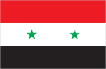
Flag
three equal horizontal bands of red (top), white, and black with two small green five-pointed stars in a horizontal line centered in the white band; similar to the flag of Yemen, which has a plain white band and of Iraq, which has three green stars (plus an Arabic inscription) in a horizontal line centered in the white band; also similar to the flag of Egypt, which has a symbolic eagle centered in the white band
Highways
total: 29,000 km paved: 22,680 km (including 670 km of expressways) (1988) unpaved: 6,320 km
Illicit drugs
a transit country for Lebanese and Turkish refined cocaine going to Europe and heroin and hashish bound for regional and Western markets
Imports
$4.1 billion (c.i.f., 1993 est.) commodities: foodstuffs 21%, metal products 17%, machinery 15% partners: EC 37%, former CEMA countries 15%, US and Canada 10% (1991)
Independence
17 April 1946 (from League of Nations mandate under French administration)
Industrial production
growth rate 21% (1991); accounts for 19% of GDP, including petroleum
Industries
textiles, food processing, beverages, tobacco, phosphate rock mining, petroleum
Infant mortality rate
42.5 deaths/1,000 live births (1994 est.)
Inflation rate (consumer prices)
16.3% (1993 est.)
Inland waterways
870 km; minimal economic importance
International disputes
separated from Israel by the 1949 Armistice Line; Golan Heights is Israeli occupied; Hatay question with Turkey; periodic disputes with Iraq over Euphrates water rights; ongoing dispute over water development plans by Turkey for the Tigris and Euphrates Rivers; Syrian troops in northern Lebanon since October 1976
Irrigated land
6,700 sq km (1989)
Judicial branch
Supreme Constitutional Court, High Judicial Council, Court of Cassation, State Security Courts
Labor force
2.951 million (1989) by occupation: miscellaneous and government services 36%, agriculture 32%, industry and construction 32%; note - shortage of skilled labor (1984)
Land boundaries
total 2,253 km, Iraq 605 km, Israel 76 km, Jordan 375 km, Lebanon 375 km, Turkey 822 km
Land use
arable land: 28% permanent crops: 3% meadows and pastures: 46% forest and woodland: 3% other: 20%
Languages
Arabic (official), Kurdish, Armenian, Aramaic, Circassian, French widely understood
Legal system
based on Islamic law and civil law system; special religious courts; has not accepted compulsory ICJ jurisdiction
Legislative branch
unicameral
Life expectancy at birth
total population: 66.46 years male: 65.37 years female: 67.61 years (1994 est.)
Literacy
age 15 and over can read and write (1990) total population: 64% male: 78% female: 51%
Location
Middle East, along the Mediterranean Sea, between Turkey and Lebanon
Manpower availability
males age 15-49 3,300,397; fit for military service 1,850,545; reach military age (19) annually 155,569 (1994 est.)
Map references
Africa, Middle East, Standard Time Zones of the World
Maritime claims
contiguous zone: 41 nm territorial sea: 35 nm
Member of
ABEDA, AFESD, AL, AMF, CAEU, CCC, ESCWA, FAO, G-24, G-77, IAEA, IBRD, ICAO, ICC, IDA, IDB, IFAD, IFC, ILO, IMF, IMO, INTELSAT, INTERPOL, IOC, ISO, ITU, LORCS, NAM, OAPEC, OIC, UN, UNCTAD, UNESCO, UNIDO, UNRWA, UPU, WFTU, WHO, WMO, WTO
Merchant marine
57 ships (1,000 GRT or over) totaling 151,519 GRT/243,910 DWT, bulk 7, cargo 48, vehicle carrier 2
Names
conventional long form: Syrian Arab Republic conventional short form: Syria local long form: Al Jumhuriyah al Arabiyah as Suriyah local short form: Suriyah former: United Arab Republic (with Egypt)
National holiday
National Day, 17 April (1946)
National product
GDP - purchasing power equivalent - $81.7 billion (1993 est.)
National product per capita
$5,700 (1993 est.)
National product real growth rate
7.6% (1993 est.)
Nationality
noun: Syrian(s) adjective: Syrian
Natural resources
petroleum, phosphates, chrome and manganese ores, asphalt, iron ore, rock salt, marble, gypsum
Net migration rate
0 migrant(s)/1,000 population (1994 est.)
Note
there are 40 Jewish settlements and civilian land use sites in the Israeli-occupied Golan Heights (April 1994)
Other political or pressure groups
non-Ba'th parties have little effective political influence; Communist party ineffective; conservative religious leaders; Muslim Brotherhood
Overview
Syria's state-dominated Ba'thist economy has benefited from the Gulf war of early 1991, increased oil production, good weather, and economic deregulation. Economic growth averaged roughly 10% in 1990-93. The Gulf war provided Syria an aid windfall of nearly $5 billion dollars from Arab, European, and Japanese donors. These inflows more than offset Damascus's war-related costs and will help Syria cover some of its debt arrears, restore suspended credit lines, and initiate selected military and civilian purchases. In 1992 the government spurred economic development by loosening controls on domestic and foreign investment while maintaining strict political controls. For the long run, Syria's economy is still saddled with a large number of poorly performing public sector firms, and industrial productivity remains to be improved. Another major long-term concern is the additional drain of upstream Euphrates water by Turkey when its vast dam and irrigation projects are completed by mid-decade.
People's Council (Majlis al-Chaab)
elections last held 22-23 May 1990 (next to be held NA May 1994); results - Ba'th 53.6%, ASU 3.2%, SCP 3.2%, Arab Socialist Unionist Movement 2.8%, ASP 2%, Democratic Socialist Union Party 1.6%, independents 33.6%; seats - (250 total) Ba'th 134, ASU 8, SCP 8, Arab Socialist Unionist Movement 7, ASP 5, Democratic Socialist Union Party 4, independents 84; note - the People's Council was expanded to 250 seats total prior to the May 1990 election
Pipelines
crude oil 1,304 km; petroleum products 515 km
Political parties and leaders
ruling party is the Arab Socialist Resurrectionist (Ba'th) Party; the Progressive National is dominated by Ba'thists but includes independents and members of the Syrian Arab Socialist Party (ASP); Arab Socialist Union (ASU); Syrian Communist Party (SCP); Arab Socialist Unionist Movement; and Democratic Socialist Union Party
Population
14,886,672 (July 1994 est.) note: in addition, there are 30,500 people living in the Israeli-occupied Golan Heights--16,500 Arabs (15,000 Druze and 1,500 Alawites) and 14,000 Jewish settlers (1994 est.)
Population growth rate
3.74% (1994 est.)
Ports
Tartus, Latakia, Baniyas, Jablah
Railroads
1,998 km total; 1,766 km standard gauge, 232 km 1.050-meter (narrow) gauge
Religions
Sunni Muslim 74%, Alawite, Druze, and other Muslim sects 16%, Christian (various sects) 10%, Jewish (tiny communities in Damascus, Al Qamishli, and Aleppo)
Suffrage
18 years of age; universal
Telecommunications
fair system currently undergoing significant improvement and digital upgrades, including fiber optic technology; 512,600 telephones (37 telephones per 1,000 persons); broadcast stations - 9 AM, 1 FM, 17 TV; satellite earth stations - 1 Indian Ocean INTELSAT and 1 Intersputnik; 1 submarine cable; coaxial cable and microwave radio relay to Iraq, Jordan, Lebanon, and Turkey
Terrain
primarily semiarid and desert plateau; narrow coastal plain; mountains in west
Total fertility rate
6.65 children born/woman (1994 est.)
Type
republic under leftwing military regime since March 1963
Unemployment rate
7.5% (1993 est.)
US diplomatic representation
chief of mission: Ambassador Christopher W. S. ROSS embassy: Abou Roumaneh, Al-Mansur Street No. 2, Damascus mailing address: P. O. Box 29, Damascus telephone: [963] (11) 332-814, 332-315, 714-108, 330-788