2005 Edition
CIA World Factbook 2005 (Project Gutenberg)
Introduction
Administrative divisions
8 regions (regions, singular - region) includes 1 capital district* (commune urbaine); Agadez, Diffa, Dosso, Maradi, Niamey*, Tahoua, Tillaberi, Zinder
Age structure
0-14 years: 47.3% (male 2,811,539/female 2,704,498) 15-64 years: 50.6% (male 2,890,119/female 3,009,281) 65 years and over: 2.1% (male 130,953/female 119,547) (2005 est.)
Agriculture - products
cowpeas, cotton, peanuts, millet, sorghum, cassava (tapioca), rice; cattle, sheep, goats, camels, donkeys, horses, poultry
Airports
27 (2004 est.)
Airports - with paved runways
- total
- 9 2,438 to 3,047 m: 2 1,524 to 2,437 m: 6 under 914 m: 1 (2004 est.)
Airports - with unpaved runways
- total
- 18 1,524 to 2,437 m: 2 914 to 1,523 m: 14 under 914 m: 2 (2004 est.) Military Niger
Area
- land
- 1,266,700 sq km
- total
- 1.267 million sq km
- water
- 300 sq km
Area - comparative
slightly less than twice the size of Texas
Background
Not until 1993, 33 years after independence from France, did Niger hold its first free and open elections. A 1995 peace accord ended a five-year Tuareg insurgency in the north. Coups in 1996 and 1999 were followed by the creation of a National Reconciliation Council that effected a transition to civilian rule by December 1999. Niger is one of the poorest countries in the world with minimal government services and insufficient funds to develop its resource base. The largely agrarian and subsistence-based economy is frequently disrupted by extended droughts common to the Sahel region of Africa. Geography Niger
Birth rate
48.3 births/1,000 population (2005 est.)
Budget
- expenditures
- $320 million, including capital expenditures of $178 million (2002 est.)
- revenues
- $320 million - including $134 million from foreign sources
Capital
Niamey
Climate
desert; mostly hot, dry, dusty; tropical in extreme south
Coastline
0 km (landlocked)
Constitution
new constitution adopted 18 July 1999
Country name
- conventional long form
- Republic of Niger
- conventional short form
- Niger
- local long form
- Republique du Niger
- local short form
- Niger
Currency (code)
Communaute Financiere Africaine franc (XOF); note - responsible authority is the Central Bank of the West African States
Currency code
XOF
Death rate
21.33 deaths/1,000 population (2005 est.)
Debt - external
$1.6 billion (1999 est.)
Diplomatic representation from the US
- chief of mission
- Ambassador Gail Dennise Thomas MATHIEU
- embassy
- Rue Des Ambassades, Niamey
- FAX
- [227] 73 31 67, 72-31-46
- mailing address
- B. P. 11201, Niamey
- telephone
- [227] 72 26 61 through 72 26 64
Diplomatic representation in the US
- chancery
- 2204 R Street NW, Washington, DC 20008
- chief of mission
- Ambassador Joseph DIATTA
- FAX
- [1] (202)483-3169
- telephone
- [1] (202) 483-4224 through 4227
Disputes - international
Libya claims about 25,000 sq km in a currently dormant dispute; much of Benin-Niger boundary, including tripoint with Nigeria, remains undemarcated, and states expect a ruling in 2005 from the ICJ over the disputed Niger and Mekrou River islands; only Nigeria and Cameroon have heeded the Lake Chad Commission's admonition to ratify the delimitation treaty which also includes Chad and Niger This page was last updated on 20 October, 2005 ======================================================================
Distribution of family income - Gini index
50.5 (1995)
Economic aid - recipient
$341 million (1997)
Economy - overview
Niger is one of the poorest countries in the world, a landlocked Sub-Saharan nation, whose economy centers on subsistence crops, livestock, and some of the world's largest uranium deposits. Drought cycles, desertification, a 3.3% population growth rate, and the drop in world demand for uranium have undercut the economy. Niger shares a common currency, the CFA franc, and a common central bank, the Central Bank of West African States (BCEAO), with seven other members of the West African Monetary Union. In December 2000, Niger qualified for enhanced debt relief under the International Monetary Fund program for Highly Indebted Poor Countries (HIPC) and concluded an agreement with the Fund on a Poverty Reduction and Growth Facility (PRGF). Debt relief provided under the enhanced HIPC initiative significantly reduces Niger's annual debt service obligations, freeing funds for expenditures on basic health care, primary education, HIV/AIDS prevention, rural infrastructure, and other programs geared at poverty reduction. Nearly half of the government's budget is derived from foreign donor resources. Future growth may be sustained by exploitation of oil, gold, coal, and other mineral resources.
Electricity - consumption
327.6 million kWh (2002)
Electricity - exports
0 kWh (2002)
Electricity - imports
80 million kWh (2002)
Electricity - production
266.2 million kWh (2002)
Electricity - production by source
- fossil fuel
- 100%
- hydro
- 0%
- nuclear
- 0%
- other
- 0% (2001)
Elevation extremes
- highest point
- Mont Bagzane 2,022 m
- lowest point
- Niger River 200 m
Environment - current issues
overgrazing; soil erosion; deforestation; desertification; wildlife populations (such as elephant, hippopotamus, giraffe, and lion) threatened because of poaching and habitat destruction
Environment - international agreements
- party to
- Biodiversity, Climate Change, Climate Change-Kyoto Protocol, Desertification, Endangered Species, Environmental Modification, Hazardous Wastes, Ozone Layer Protection, Wetlands signed, but not ratified: Law of the Sea
Ethnic groups
Hausa 56%, Djerma 22%, Fula 8.5%, Tuareg 8%, Beri Beri (Kanouri) 4.3%, Arab, Toubou, and Gourmantche 1.2%, about 1,200 French expatriates
Exchange rates
Communaute Financiere Africaine francs (XOF) per US dollar - 528.29 (2004), 581.2 (2003), 696.99 (2002), 733.04 (2001), 711.98 (2000)
Executive branch
- cabinet
- 27-member Cabinet appointed by the president
- chief of state
- President TANDJA Mamadou (since 22 December 1999); note - the president is both chief of state and head of government
- election results
- TANDJA Mamadou reelected president; percent of vote - TANDJA Mamadou 65.5%, Mahamadou ISSOUFOU 34.5%
- elections
- president elected by popular vote for a five-year term; second round last held 4 December 2004 (next to be held December 2009); prime minister appointed by the president
- head of government
- President TANDJA Mamadou (since 22 December 1999); note - the president is both chief of state and head of government; Prime Minister Hama AMADOU (since 31 December 1999) was appointed by the president and shares some executive responsibilities with the president
Exports
$280 million f.o.b. (2002 est.)
Exports - commodities
uranium ore, livestock, cowpeas, onions
Exports - partners
France 41%, Nigeria 22.4%, Japan 15.3%, Switzerland 6%, Spain 4.1%, Ghana 4% (2004)
Fiscal year
calendar year Communications Niger
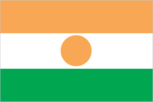
Flag description
three equal horizontal bands of orange (top), white, and green with a small orange disk (representing the sun) centered in the white band; similar to the flag of India, which has a blue spoked wheel centered in the white band Economy Niger
GDP - composition by sector
- agriculture
- 39%
- industry
- 17%
- services
- 44% (2001)
GDP - per capita
purchasing power parity - $900 (2004 est.)
GDP - real growth rate
3.5% (2004 est.)
GDP (purchasing power parity)
$9.716 billion (2004 est.)
Geographic coordinates
16 00 N, 8 00 E
Geography - note
landlocked; one of the hottest countries in the world: northern four-fifths is desert, southern one-fifth is savanna, suitable for livestock and limited agriculture People Niger
Government type
republic
Highways
- paved
- 798 km
- total
- 10,100 km
- unpaved
- 9,302 km (1999 est.)
HIV/AIDS - adult prevalence rate
1.2% (2003 est.)
HIV/AIDS - deaths
4,800 (2003 est.)
HIV/AIDS - people living with HIV/AIDS
70,000 (2003 est.)
Household income or consumption by percentage share
lowest 10%: 0.8% highest 10%: 35.4% (1995)
Imports
$400 million f.o.b. (2002 est.)
Imports - commodities
foodstuffs, machinery, vehicles and parts, petroleum, cereals
Imports - partners
France 14.4%, US 10.3%, French Polynesia 9.4%, Nigeria 7.8%, Cote d'Ivoire 7.5%, Japan 5.2%, China 5.1%, Thailand 4.1% (2004)
Independence
3 August 1960 (from France)
Industrial production growth rate
NA (2001 est.)
Industries
uranium mining, cement, brick, soap, textiles, food processing, chemicals, slaughterhouses
Infant mortality rate
- female
- 117.33 deaths/1,000 live births (2005 est.)
- male
- 125.93 deaths/1,000 live births
- total
- 121.69 deaths/1,000 live births
Inflation rate (consumer prices)
3% (2002 est.)
International organization participation
ACCT, ACP, AfDB, AU, ECOWAS, Entente, FAO, FZ, G-77, IAEA, IBRD, ICAO, ICCt, ICFTU, ICRM, IDA, IDB, IFAD, IFC, IFRCS, ILO, IMF, Interpol, IOC, IOM, ISO (subscriber), ITU, MONUC, NAM, OIC, ONUB, OPCW, UN, UNCTAD, UNESCO, UNIDO, UNMIL, UNOCI, UPU, WADB (regional), WAEMU, WCL, WCO, WFTU, WHO, WIPO, WMO, WToO, WTO
Internet country code
.ne
Internet hosts
134 (2003)
Internet Service Providers (ISPs)
1 (2002)
Internet users
15,000 (2002) Transportation Niger
Irrigated land
660 sq km (1998 est.)
Judicial branch
State Court or Cour d'Etat; Court of Appeal or Cour d'Appel
Labor force
70,000 receive regular wages or salaries (2002 est.)
Labor force - by occupation
agriculture 90%, industry and commerce 6%, government 4%
Land boundaries
- border countries
- Algeria 956 km, Benin 266 km, Burkina Faso 628 km, Chad 1,175 km, Libya 354 km, Mali 821 km, Nigeria 1,497 km
- total
- 5,697 km
Land use
- arable land
- 3.54%
- other
- 96.45% (2001)
- permanent crops
- 0.01%
Languages
French (official), Hausa, Djerma
Legal system
based on French civil law system and customary law; has not accepted compulsory ICJ jurisdiction
Legislative branch
- unicameral National Assembly (113 seats; note - expanded from 83 seats; members elected by popular vote for five-year terms)
- election results
- percent of vote by party - NA%; seats by party - MNSD 47, CDS 22, PNDS 17, RSD 7, RDP 6, ANDP 5, Party for Socialism and Democracy in Niger 1, other 8
- elections
- last held 4 December 2004 (next to be held December 2009)
Life expectancy at birth
- female
- 43.45 years (2005 est.)
- male
- 43.54 years
- total population
- 43.5 years
Literacy
- definition: age 15 and over can read and write
- female
- 9.7% (2003 est.) Government Niger
- male
- 25.8%
- total population
- 17.6%
Location
Western Africa, southeast of Algeria
Major infectious diseases
- degree of risk
- very high
- food or waterborne diseases
- bacterial and protozoal diarrhea, hepatitis A, and typhoid fever
- respiratory disease
- meningococcal meningitis (2004)
- vectorborne disease
- malaria is a high risk in some locations
Manpower available for military service
males age 18-49: 2,135,680 (2005 est.)
Manpower fit for military service
males age 18-49: 1,180,027 (2005 est.)
Manpower reaching military service age annually
- males
- 126,719 (2005 est.)
Map references
Africa
Maritime claims
none (landlocked)
Median age
- female
- 16.72 years (2005 est.)
- male
- 15.8 years
- total
- 16.25 years
Military branches
Niger Armed Forces (Forces Armees Nigeriennes, FAN): Army, National Air Force (2005)
Military expenditures - dollar figure
$33.3 million (2004)
Military expenditures - percent of GDP
1.1% (2004) Transnational Issues Niger
Military service age and obligation
18 years of age for compulsory military service; conscript service obligation - 2 years (2004)
National holiday
Republic Day, 18 December (1958)
Nationality
- adjective
- Nigerien
- noun
- Nigerien(s)
Natural hazards
recurring droughts
Natural resources
uranium, coal, iron ore, tin, phosphates, gold, molybdenum, gypsum, salt, petroleum
Net migration rate
-0.65 migrant(s)/1,000 population (2005 est.)
Oil - consumption
5,000 bbl/day (2001 est.)
Oil - exports
NA
Oil - imports
NA
Oil - production
0 bbl/day (2001 est.)
Political parties and leaders
Alliance for Democracy and Progress or ANDP [leader NA]; Democratic Rally of the People-Jama'a or RDP-Jama'a [Hamid ALGABID]; Democratic and Social Convention-Rahama or CDS-Rahama [Mahamane OUSMANE]; National Movement for a Developing Society-Nassara or MNSD-Nassara [TANDJA Mamadou, chairman]; Nigerien Alliance for Democracy and Social Progress-Zaman Lahiya or ANDPS-Zaman Lahiya [Moumouni Adamou DJERMAKOYE]; Nigerien Party for Democracy and Socialism-Tarayya or PNDS-Tarayya [Mahamadou ISSOUFOU]; Party for Socialism and Democracy in Niger [leader NA]; Rally for Social Democracy or RSD [Cheiffou AMADOU]; Union of Democratic Patriots and Progressives-Chamoua or UPDP-Chamoua [Professor Andre' SALIFOU, chairman]
Political pressure groups and leaders
NA
Population
11,665,937 (July 2005 est.)
Population below poverty line
63% (1993 est.)
Population growth rate
2.63% (2005 est.)
Ports and harbors
none
Radio broadcast stations
AM 5, FM 6, shortwave 4 (2001)
Radios
680,000 (1997)
Religions
Muslim 80%, remainder indigenous beliefs and Christian
Sex ratio
- at birth
- 1.03 male(s)/female under 15 years: 1.04 male(s)/female 15-64 years: 0.96 male(s)/female 65 years and over: 1.1 male(s)/female
- total population
- 1 male(s)/female (2005 est.)
Suffrage
18 years of age; universal
Telephone system
- domestic
- wire, radiotelephone communications, and microwave radio relay; domestic satellite system with 3 earth stations and 1 planned
- general assessment
- small system of wire, radio telephone communications, and microwave radio relay links concentrated in the southwestern area of Niger
- international
- country code - 227; satellite earth stations - 2 Intelsat (1 Atlantic Ocean and 1 Indian Ocean)
Telephones - main lines in use
22,400 (2002)
Telephones - mobile cellular
24,000 (2003)
Television broadcast stations
3 (plus seven low-power repeaters) (2002)
Televisions
125,000 (1997)
Terrain
predominately desert plains and sand dunes; flat to rolling plains in south; hills in north
Total fertility rate
6.75 children born/woman (2005 est.)
Unemployment rate
NA (2002 est.)
Waterways
300 km note: Niger River is navigable to Gaya between September and March (2004)