2007 Edition
CIA World Factbook 2007 (Project Gutenberg)
Introduction
Administrative divisions
n13 regions; Caprivi, Erongo, Hardap, Karas, Khomas, Kunene, Ohangwena, Okavango, Omaheke, Omusati, Oshana, Oshikoto, Otjozondjupa
Age structure
0-14 years: 38.2% (male 393,878/female 387,147) 15-64 years: 58.1% (male 596,557/female 591,350) 65 years and over: 3.7% (male 34,245/female 40,970) (2006 est.)
Agriculture - products
millet, sorghum, peanuts, grapes; livestock; fish
Airports
137 (2006)
Airports - with paved runways
- over 3,047 m
- 3 2,438 to 3,047 m: 2 1,524 to 2,437 m: 13 914 to 1,523 m: 3 (2006)
- total
- 21
Airports - with unpaved runways
- total
- 116 2,438 to 3,047 m: 2 1,524 to 2,437 m: 22 914 to 1,523 m: 72
- under 914 m
- 20 (2006)
Area
- land
- 825,418 sq km
- total
- 825,418 sq km
- water
- 0 sq km
Area - comparative
slightly more than half the size of Alaska
Background
South Africa occupied the German colony of South-West Africa during World War I and administered it as a mandate until after World War II, when it annexed the territory. In 1966 the Marxist South-West Africa People's Organization (SWAPO) guerrilla group launched a war of independence for the area that was soon named Namibia, but it was not until 1988 that South Africa agreed to end its administration in accordance with a UN peace plan for the entire region. Namibia won its independence in 1990 and has been governed by SWAPO since. Hifikepunye POHAMBA was elected president in November 2004 in a landslide victory replacing Sam NUJOMA who led the country during its first 14 years of self rule. Geography Namibia
Birth rate
24.32 births/1,000 population (2006 est.)
Budget
- expenditures
- $2.214 billion; including capital expenditures of $NA (2006 est.)
- revenues
- $2.233 billion
Capital
- daylight saving time
- +1hr, begins first Sunday in September; ends first Sunday in April
- geographic coordinates
- 22 34 S, 17 06 E
- name
- Windhoek
- time difference
- UTC+1 (6 hours ahead of Washington, DC during Standard Time)
Climate
desert; hot, dry; rainfall sparse and erratic
Coastline
1,572 km
Constitution
ratified 9 February 1990, effective 12 March 1990
Country name
- conventional long form
- Republic of Namibia
- conventional short form
- Namibia
- former
- German Southwest Africa, South-West Africa
- local long form
- Republic of Namibia
- local short form
- Namibia
Currency (code)
Namibian dollar (NAD); South African rand (ZAR)
Currency code
NAD; ZAR
Current account balance
$572 million (2006 est.)
Death rate
18.86 deaths/1,000 population (2006 est.)
Debt - external
$887 million (2006 est.)
Diplomatic representation from the US
- chief of mission
- Ambassador Joyce BARR
- embassy
- Ausplan Building, 14 Lossen Street, Windhoek
- mailing address
- Private Bag 12029 Ausspannplatz, Windhoek
- telephone
- [264] (61) 221601
Diplomatic representation in the US
- chancery
- 1605 New Hampshire Avenue NW, Washington, DC 20009
- chief of mission
- Ambassador Patrick NANDAGO
- telephone
- [1] (202) 986-0540
Disputes - international
concerns from international experts and local populations over the Okavango Delta ecology in Botswana and human displacement scuttled Namibian plans to construct a hydroelectric dam on Popa Falls along the Angola-Namibia border; managed dispute with South Africa over the location of the boundary in the Orange River; Namibia has supported and in 2004 Zimbabwe dropped objections to plans between Botswana and Zambia to build a bridge over the Zambezi River, thereby de facto recognizing a short, but not clearly delimited, Botswana-Zambia boundary in the river
Distribution of family income - Gini index
70.7 (2003)
Economic aid - recipient
ODA, $160 million (2000 est.)
Economy - overview
The economy is heavily dependent on the extraction and processing of minerals for export. Mining accounts for 20% of GDP. Rich alluvial diamond deposits make Namibia a primary source for gem-quality diamonds. Namibia is the fourth-largest exporter of nonfuel minerals in Africa, the world's fifth-largest producer of uranium, and the producer of large quantities of lead, zinc, tin, silver, and tungsten. The mining sector employs only about 3% of the population while about half of the population depends on subsistence agriculture for its livelihood. Namibia normally imports about 50% of its cereal requirements; in drought years food shortages are a major problem in rural areas. A high per capita GDP, relative to the region, hides the world's worst inequality of income distribution. The Namibian economy is closely linked to South Africa with the Namibian dollar pegged one-to-one to the South African rand. Privatization of several enterprises in coming years may stimulate long-run foreign investment. Increased fish production and mining of zinc, copper, uranium, and silver spurred growth in 2003-06.
Electricity - consumption
2.819 billion kWh (2004)
Electricity - exports
80 million kWh (2004)
Electricity - imports
1.6 billion kWh; note - electricity supplied by South Africa (2004)
Electricity - production
1.397 billion kWh (2004)
Electricity - production by source
NA
Elevation extremes
- highest point
- Konigstein 2,606 m
- lowest point
- Atlantic Ocean 0 m
Environment - current issues
very limited natural fresh water resources; desertification; wildlife poaching; land degradation has led to few conservation areas
Environment - international agreements
- party to
- Antarctic-Marine Living Resources, Biodiversity, Climate Change, Climate Change-Kyoto Protocol, Desertification, Endangered Species, Hazardous Wastes, Law of the Sea, Ozone Layer Protection, Wetlands
- signed, but not ratified
- none of the selected agreements
Ethnic groups
- black 87.5%, white 6%, mixed 6.5%
- note
- about 50% of the population belong to the Ovambo tribe and 9% to the Kavangos tribe; other ethnic groups includes Herero 7%, Damara 7%, Nama 5%, Caprivian 4%, Bushmen 3%, Baster 2%, Tswana 0.5%
Exchange rates
Namibian dollars per US dollar - 6.85 (2006), 6.3593 (2005), 6.4597 (2004), 7.5648 (2003), 10.5407 (2002)
Executive branch
- cabinet
- Cabinet appointed by the president from among the members of the National Assembly
- chief of state
- President Hifikepunye POHAMBA (since 21 March 2005)
- election results
- Hifikepunye POHAMBA elected president; percent of vote - Hifikepunye POHAMBA 76.4%, Den ULENGA 7.3%, Katuutire KAURA 5.1%, Kuaima RIRUAKO 4.2%, Justus GAROEB 3.8%, other 3.2%
- elections
- president elected by popular vote for a five-year term (eligible for a second term); election last held 15 November 2004 (next to be held November 2009)
- head of government
- Prime Minister Nahas ANGULA (since 21 March 2005)
Exports
$2.321 billion f.o.b. (2006 est.)
Exports - commodities
diamonds, copper, gold, zinc, lead, uranium; cattle, processed fish, karakul skins
Exports - partners
South Africa 33.4%, US 4% (2004)
FAX
- [1] (202) 986-0443
- [264] (61) 229792
Fiscal year
1 April - 31 March Communications Namibia
Flag description
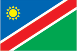
a large blue triangle with a yellow sunburst fills the upper left section and an equal green triangle (solid) fills the lower right section; the triangles are separated by a red stripe that is contrasted by two narrow white-edge borders Economy Namibia
GDP - composition by sector
- agriculture
- 11.8%
- industry
- 30.2%
- services
- 58.1% (2006 est.)
GDP - per capita (PPP)
$7,400 (2006 est.)
GDP - real growth rate
4.1% (2006 est.)
GDP (official exchange rate)
$5.304 billion (2006 est.)
GDP (purchasing power parity)
$15.04 billion (2006 est.)
Geographic coordinates
22 00 S, 17 00 E
Geography - note
first country in the world to incorporate the protection of the environment into its constitution; some 14% of the land is protected, including virtually the entire Namib Desert coastal strip People Namibia
Government type
republic
HIV/AIDS - adult prevalence rate
21.3% (2003 est.)
HIV/AIDS - deaths
16,000 (2003 est.)
HIV/AIDS - people living with HIV/AIDS
210,000 (2001 est.)
Household income or consumption by percentage share
- highest 10%
- 64.5%
- lowest 10%
- 0.5%
Imports
$2.456 billion f.o.b. (2006 est.)
Imports - commodities
foodstuffs; petroleum products and fuel, machinery and equipment, chemicals
Imports - partners
South Africa 85.2%, US (2004)
Independence
21 March 1990 (from South African mandate)
Industrial production growth rate
NA%
Industries
meatpacking, fish processing, dairy products; mining (diamonds, lead, zinc, tin, silver, tungsten, uranium, copper)
Infant mortality rate
- female
- 44.09 deaths/1,000 live births (2006 est.)
- male
- 51.99 deaths/1,000 live births
- total
- 48.1 deaths/1,000 live births
Inflation rate (consumer prices)
5% (2006 est.)
International organization participation
ACP, AfDB, AU, C, FAO, G-77, IAEA, IBRD, ICAO, ICCt, ICRM, IFAD, IFC, IFRCS, ILO, IMF, IMO, Interpol, IOC, IOM (observer), IPU, ISO (correspondent), ITU, MIGA, NAM, ONUB, OPCW, SACU, SADC, UN, UNCTAD, UNESCO, UNHCR, UNIDO, UNMEE, UNMIL, UNMIS, UNOCI, UNWTO, UPU, WCL, WCO, WHO, WIPO, WMO, WTO
Internet country code
.na
Internet hosts
3,527 (2006)
Internet Service Providers (ISPs)
2 (2000)
Internet users
75,000 (2005) Transportation Namibia
Investment (gross fixed)
25% of GDP (2006 est.)
Irrigated land
80 sq km (2003)
Judicial branch
Supreme Court (judges appointed by the president on the recommendation of the Judicial Service Commission)
Labor force
653,000 (2006 est.)
Labor force - by occupation
- agriculture
- 47%
- industry
- 20%
- services
- 33% (1999 est.)
Land boundaries
- border countries
- Angola 1,376 km, Botswana 1,360 km, South Africa 967 km, Zambia 233 km
- total
- 3,936 km
Land use
- arable land
- 0.99%
- other
- 99% (2005)
- permanent crops
- 0.01%
Languages
English 7% (official), Afrikaans common language of most of the population and about 60% of the white population, German 32%, indigenous languages (Oshivambo, Herero, Nama)
Legal system
based on Roman-Dutch law and 1990 constitution
Legislative branch
- bicameral legislature consists of the National Council (26 seats; 2 members are chosen from each regional council to serve six-year terms) and the National Assembly (72 seats; members are elected by popular vote to serve five-year terms)
- election results
- National Council - percent of vote by party - SWAPO 89.7%, UDF 4.7%, NUDO 2.8%, DTA 1.9%; seats by party - SWAPO 24, UDF 1, DTA 1; National Assembly - percent of vote by party - SWAPO 76.1%, COD 7.3%, DTA 5.1%, NUDO 4.2%, UDF 3.6%, RP 1.9%, MAG 0.8%, other 1.0%; seats by party - SWAPO 55, COD 5, DTA 4, NUDO 3, UDF 3, RP 1, MAG 1
- elections
- National Council - elections for regional councils, to determine members of the National Council, held 29-30 November 2004 (next to be held November 2010); National Assembly - last held 15-16 November 2004 (next to be held November 2009)
- note
- the National Council is primarily an advisory body
Life expectancy at birth
- female
- 42.29 years (2006 est.)
- male
- 44.46 years
- total population
- 43.39 years
Literacy
- definition
- age 15 and over can read and write
- female
- 83.7% (2003 est.) Government Namibia
- male
- 84.4%
- total population
- 84%
Location
Southern Africa, bordering the South Atlantic Ocean, between Angola and South Africa
Major infectious diseases
- degree of risk
- high
- food or waterborne diseases
- bacterial diarrhea, hepatitis A, and typhoid fever
- vectorborne disease
- malaria
- water contact disease
- schistosomiasis (2007)
Manpower available for military service
- males age 18-49
- 441,293 (2005 est.)
Manpower fit for military service
- males age 18-49
- 217,118 (2005 est.)
Map references
Africa
Maritime claims
- contiguous zone
- 24 nm
- exclusive economic zone
- 200 nm
- territorial sea
- 12 nm
Median age
- female
- 20.1 years (2006 est.)
- male
- 19.8 years
- total
- 20 years
Merchant marine
- by type
- cargo 1 (2006)
- total
- 1 ship (1000 GRT or over) 2,265 GRT/3,605 DWT
Military expenditures - dollar figure
$149.5 million (2005 est.)
Military expenditures - percent of GDP
2.3% (2005 est.) Transnational Issues Namibia
Military service age and obligation
18 years of age for voluntary military service (2001)
Namibian Defense Force
Army, Air Wing, Navy (2006)
National holiday
Independence Day, 21 March (1990)
Nationality
- adjective
- Namibian
- noun
- Namibian(s)
Natural gas - consumption
0 cu m (2004 est.)
Natural gas - production
0 cu m (2004 est.)
Natural gas - proved reserves
62.3 billion cu m (1 January 2005 est.)
Natural hazards
prolonged periods of drought
Natural resources
- diamonds, copper, uranium, gold, lead, tin, lithium, cadmium, zinc, salt, hydropower, fish
- note
- suspected deposits of oil, coal, and iron ore
Net migration rate
0.47 migrant(s)/1,000 population (2006 est.)
Oil - consumption
18,000 bbl/day (2004 est.)
Oil - exports
NA bbl/day (2001)
Oil - imports
12,770 bbl/day (2003)
Oil - production
0 bbl/day (2004 est.)
Oil - proved reserves
0 bbl (1 January 2002)
Political parties and leaders
Congress of Democrats or COD [Ben ULENGA]; Democratic Turnhalle Alliance of Namibia or DTA [Katuutire KAURA, president]; Monitor Action Group or MAG [Jurie VILJOEN]; National Democratic Movement for Change or NamDMC; National Unity Democratic Organization or NUDO [Kuaima RIRUAKO]; Republican Party or RP [Henk MUDGE]; South West Africa National Union or SWANU [Rihupisa KANDANDO]; South West Africa People's Organization or SWAPO [Sam Shafishuna NUJOMA]; United Democratic Front or UDF [Justus GAROEB]
Political pressure groups and leaders
NA
Population
- 2,044,147
- note
- estimates for this country explicitly take into account the effects of excess mortality due to AIDS; this can result in lower life expectancy, higher infant mortality and death rates, lower population and growth rates, and changes in the distribution of population by age and sex than would otherwise be expected (July 2006 est.)
Population below poverty line
the UNDP's 2005 Human Development Report indicated that 34.9% of the population live on $1 per day and 55.8% live on $2 per day
Population growth rate
0.59% (2006 est.)
Ports and terminals
Luderitz, Walvis Bay Military Namibia
Public debt
31.6% of GDP (2006 est.)
Radio broadcast stations
AM 2, FM 39, shortwave 4 (2001)
Radios
232,000 (1997)
Railways
- narrow gauge
- 2,382 km 1.067-m gauge (2005)
- total
- 2,382 km
Refugees and internally displaced persons
- refugees (country of origin)
- 11,900 (Angola) (2006) This page was last updated on 8 February, 2007
Religions
Christian 80% to 90% (Lutheran 50% at least), indigenous beliefs 10% to 20%
Reserves of foreign exchange and gold
$480 million (2006 est.)
Roadways
- paved
- 5,406 km
- total
- 42,237 km
- unpaved
- 36,831 km (2002)
Sex ratio
- at birth
- 1.03 male(s)/female
- total population
- 1.01 male(s)/female (2006 est.)
- under 15 years
- 1.02 male(s)/female 15-64 years: 1.01 male(s)/female 65 years and over: 0.84 male(s)/female
Suffrage
18 years of age; universal
Telephone system
- domestic
- good urban services; fair rural service; microwave radio relay links major towns; connections to other populated places are by open wire; 100% digital
- general assessment
- good system; about 6 telephones for each 100 persons
- international
- country code - 264; fiber-optic cable to South Africa, microwave radio relay link to Botswana, direct links to other neighboring countries; connected to Africa ONE and South African Far East (SAFE) submarine cables through South Africa; satellite earth stations - 4 Intelsat (2002)
Telephones - main lines in use
127,900 (2004)
Telephones - mobile cellular
495,000 (2005)
Television broadcast stations
8 (plus about 20 low-power repeaters) (1997)
Televisions
60,000 (1997)
Terrain
mostly high plateau; Namib Desert along coast; Kalahari Desert in east
Total fertility rate
3.06 children born/woman (2006 est.)
Unemployment rate
5.3% (2006 est.)