2005 Edition
CIA World Factbook 2005 (Project Gutenberg)
Introduction
Administrative divisions
28 states and 7 union territories*; Andaman and Nicobar Islands*, Andhra Pradesh, Arunachal Pradesh, Assam, Bihar, Chandigarh*, Chhattisgarh, Dadra and Nagar Haveli*, Daman and Diu*, Delhi*, Goa, Gujarat, Haryana, Himachal Pradesh, Jammu and Kashmir, Jharkhand, Karnataka, Kerala, Lakshadweep*, Madhya Pradesh, Maharashtra, Manipur, Meghalaya, Mizoram, Nagaland, Orissa, Pondicherry*, Punjab, Rajasthan, Sikkim, Tamil Nadu, Tripura, Uttaranchal, Uttar Pradesh, West Bengal
Age structure
0-14 years: 31.2% (male 173,634,432/female 163,932,475) 15-64 years: 63.9% (male 356,932,082/female 333,283,590) 65 years and over: 4.9% (male 26,542,025/female 25,939,784) (2005 est.)
Agriculture - products
rice, wheat, oilseed, cotton, jute, tea, sugarcane, potatoes; cattle, water buffalo, sheep, goats, poultry; fish
Airports
333 (2004 est.)
Airports - with paved runways
- total
- 234 over 3,047 m: 14 2,438 to 3,047 m: 47 1,524 to 2,437 m: 78 914 to 1,523 m: 74 under 914 m: 21 (2004 est.)
Airports - with unpaved runways
- total
- 99 2,438 to 3,047 m: 3 1,524 to 2,437 m: 9 914 to 1,523 m: 42 under 914 m: 45 (2004 est.)
Area
- land
- 2,973,190 sq km
- total
- 3,287,590 sq km
- water
- 314,400 sq km
Area - comparative
slightly more than one-third the size of the US
Background
The Indus Valley civilization, one of the oldest in the world, dates back at least 5,000 years. Aryan tribes from the northwest invaded about 1500 B.C.; their merger with the earlier Dravidian inhabitants created the classical Indian culture. Arab incursions starting in the 8th century and Turkish in the 12th were followed by those of European traders, beginning in the late 15th century. By the 19th century, Britain had assumed political control of virtually all Indian lands. Indian armed forces in the British army played a vital role in both World Wars. Nonviolent resistance to British colonialism led by Mohandas GANDHI and Jawaharlal NEHRU brought independence in 1947. The subcontinent was divided into the secular state of India and the smaller Muslim state of Pakistan. A third war between the two countries in 1971 resulted in East Pakistan becoming the separate nation of Bangladesh. Despite impressive gains in economic investment and output, India faces pressing problems such as the ongoing dispute with Pakistan over Kashmir, massive overpopulation, environmental degradation, extensive poverty, and ethnic and religious strife. Geography India
Birth rate
22.32 births/1,000 population (2005 est.)
Budget
- expenditures
- $104 billion, including capital expenditures of $13.5 billion (2004 est.)
- revenues
- $67.3 billion
Capital
New Delhi
Climate
varies from tropical monsoon in south to temperate in north
Coastline
7,000 km
Constitution
26 January 1950; amended many times
Country name
- conventional long form
- Republic of India
- conventional short form
- India
Currency (code)
Indian rupee (INR)
Currency code
INR
Current account balance
$4.897 billion (2004 est.)
Death rate
8.28 deaths/1,000 population (2005 est.)
Debt - external
$117.2 billion (2004 est.)
Diplomatic representation from the US
- chief of mission
- Ambassador David C. MULFORD
- consulate(s) general
- Chennai (Madras), Kolkata (Calcutta), Mumbai (Bombay)
- embassy
- Shantipath, Chanakyapuri, New Delhi 110021
- FAX
- [91] (11) 2419-0017
- mailing address
- use embassy street address
- telephone
- [91] (11) 2419-8000
Diplomatic representation in the US
- chancery
- 2107 Massachusetts Avenue NW, Washington, DC 20008; note - Consular Wing located at 2536 Massachusetts Avenue NW, Washington, DC 20008
- chief of mission
- Ambassador Ranendra SEN
- consulate(s) general
- Chicago, Houston, New York, and San Francisco
- FAX
- [1] (202) 265-4351
- telephone
- [1] (202) 939-7000
Disputes - international
China and India launched a security and foreign policy dialogue in 2005, consolidating discussions related to the dispute over most of their rugged, militarized boundary, regional nuclear proliferation, Indian claims that China transferred missiles to Pakistan, and other matters; recent talks and confidence-building measures have begun to defuse tensions over Kashmir, site of the world's largest and most militarized territorial dispute with portions under the de facto administration of China (Aksai Chin), India (Jammu and Kashmir), and Pakistan (Azad Kashmir and Northern Areas); in 2004, India and Pakistan instituted a cease fire in the Kashmir and in 2005, restored bus service across the highly militarized Line of Control; Pakistan has taken its dispute on the impact and benefits of India's building the Baglihar dam on the Chenab River in Jammu and Kashmir to the World Bank for arbitration; UN Military Observer Group in India and Pakistan (UNMOGIP) has maintained a small group of peacekeepers since 1949; India does not recognize Pakistan's ceding historic Kashmir lands to China in 1964; disputes persist with Pakistan over Indus River water sharing; to defuse tensions and prepare for discussions on a maritime boundary, in 2004, India and Pakistan resurveyed a portion of the disputed boundary in Sir Creek estuary at the mouth of the Rann of Kutch; Pakistani maps continue to show Junagadh claim in Indian Gujarat State; discussions with Bangladesh remain stalled to delimit a small section of river boundary, to exchange 162 miniscule enclaves in both countries, to allocate divided villages, and to stop illegal cross-border trade, migration, violence, and transit of terrorists through the porous border; Bangladesh protests India's attempts to fence off high-traffic sections; dispute with Bangladesh over New Moore/South Talpatty/Purbasha Island in the Bay of Bengal deters maritime boundary delimitation; India seeks cooperation from Bhutan and Burma to keep Indian Nagaland and Assam separatists from hiding in remote areas along the borders; Joint Border Committee with Nepal continues to demarcate minor disputed boundary sections; India has instituted a stricter border regime to keep out Maoist insurgents and control illegal cross-border activities from Nepal
Distribution of family income - Gini index
37.8 (1997)
Economic aid - recipient
$2.9 billion (FY98/99)
Economy - overview
India's diverse economy encompasses traditional village farming, modern agriculture, handicrafts, a wide range of modern industries, and a multitude of services. Services are the major source of economic growth, though two-thirds of the workforce is in agriculture. The UPA government has committed to furthering economic reforms and developing basic infrastructure to improve the lives of the rural poor and boost economic performance. Government controls on foreign trade and investment have been reduced in some areas, but high tariffs (averaging 20% in 2004) and limits on foreign direct investment are still in place. The government has indicated it will do more to liberalize investment in civil aviation, telecom, and insurance sectors in the near term. Privatization of government-owned industries has proceeded slowly, and continues to generate political debate; continued social, political, and economic rigidities hold back needed initiatives. The economy has posted an excellent average growth rate of 6.8% since 1994, reducing poverty by about 10 percentage points. India is capitalizing on its large numbers of well-educated people skilled in the English language to become a major exporter of software services and software workers. Despite strong growth, the World Bank and others worry about the combined state and federal budget deficit, running at approximately 9% of GDP. The huge and growing population is the fundamental social, economic, and environmental problem. In late December 2004, a major tsunami took nearly 11,000 lives, left almost 6,000 missing, destroyed $1.2 billion worth of property, and severely damaged the fishing fleet.
Electricity - consumption
510.1 billion kWh (2002)
Electricity - exports
350 million kWh (2002)
Electricity - imports
1.54 billion kWh (2002)
Electricity - production
547.2 billion kWh (2002)
Electricity - production by source
- fossil fuel
- 81.7%
- hydro
- 14.5%
- nuclear
- 3.4%
- other
- 0.3% (2001)
Elevation extremes
- highest point
- Kanchenjunga 8,598 m
- lowest point
- Indian Ocean 0 m
Environment - current issues
deforestation; soil erosion; overgrazing; desertification; air pollution from industrial effluents and vehicle emissions; water pollution from raw sewage and runoff of agricultural pesticides; tap water is not potable throughout the country; huge and growing population is overstraining natural resources
Environment - international agreements
- party to
- Antarctic-Environmental Protocol, Antarctic-Marine Living Resources, Antarctic Treaty, Biodiversity, Climate Change, Climate Change-Kyoto Protocol, Desertification, Endangered Species, Environmental Modification, Hazardous Wastes, Law of the Sea, Ozone Layer Protection, Ship Pollution, Tropical Timber 83, Tropical Timber 94, Wetlands, Whaling signed, but not ratified: none of the selected agreements
Ethnic groups
Indo-Aryan 72%, Dravidian 25%, Mongoloid and other 3% (2000)
Exchange rates
Indian rupees per US dollar - 45.317 (2004), 46.583 (2003), 48.61 (2002), 47.186 (2001), 44.942 (2000)
Executive branch
- cabinet
- Council of Ministers appointed by the president on the recommendation of the prime minister
- chief of state
- President A.P.J. Abdul KALAM (since 26 July 2002); Vice President Bhairon Singh SHEKHAWAT (since 19 August 2002)
- election results
- Abdul KALAM elected president; percent of electoral college vote - 89.6%; Bhairon Singh SHEKHAWAT elected vice president; percent of Parliament vote - 59.8%
- elections
- president elected by an electoral college consisting of elected members of both houses of Parliament and the legislatures of the states for a five-year term; election last held July 2002 (next to be held 18 July 2007); vice president elected by both houses of Parliament for a five-year term; election last held 12 August 2002 (next to be held August 2007); prime minister chosen by parliamentary members of the majority party following legislative elections; election last held April - May 2004 (next to be held May 2009)
- head of government
- Prime Minister Manmohan SINGH (since NA May 2004)
Exports
$69.18 billion f.o.b. (2004 est.)
Exports - commodities
textile goods, gems and jewelry, engineering goods, chemicals, leather manufactures
Exports - partners
US 17%, UAE 8.8%, China 5.5%, Hong Kong 4.7%, UK 4.5%, Singapore 4.5% (2004)
Fiscal year
1 April - 31 March Communications India
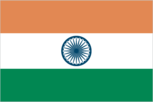
Flag description
three equal horizontal bands of saffron (subdued orange) (top), white, and green with a blue chakra (24-spoked wheel) centered in the white band; similar to the flag of Niger, which has a small orange disk centered in the white band Economy India
GDP - composition by sector
- agriculture
- 23.6%
- industry
- 28.4%
- services
- 48% (2002 est.)
GDP - per capita
purchasing power parity - $3,100 (2004 est.)
GDP - real growth rate
6.2% (2004 est.)
GDP (purchasing power parity)
$3.319 trillion (2004 est.)
Geographic coordinates
20 00 N, 77 00 E
Geography - note
dominates South Asian subcontinent; near important Indian Ocean trade routes People India
Government type
federal republic
Heliports
20 (2004 est.) Military India
Highways
- paved
- 1,448,655 km
- total
- 2,525,989 km
- unpaved
- 1,077,334 km (1999)
HIV/AIDS - adult prevalence rate
0.9% (2001 est.)
HIV/AIDS - deaths
310,000 (2001 est.)
HIV/AIDS - people living with HIV/AIDS
5.1 million (2001 est.)
Household income or consumption by percentage share
lowest 10%: 3.5% highest 10%: 33.5% (1997)
Illicit drugs
world's largest producer of licit opium for the pharmaceutical trade, but an undetermined quantity of opium is diverted to illicit international drug markets; transit point for illicit narcotics produced in neighboring countries; illicit producer of methaqualone; vulnerable to narcotics money laundering through the hawala system This page was last updated on 20 October, 2005 ======================================================================
Imports
$89.33 billion f.o.b. (2004 est.)
Imports - commodities
crude oil, machinery, gems, fertilizer, chemicals
Imports - partners
China 6.1%, US 6%, Switzerland 5.2%, Belgium 4.4% (2004)
Independence
15 August 1947 (from UK)
Industrial production growth rate
7.4% (2004 est.)
Industries
textiles, chemicals, food processing, steel, transportation equipment, cement, mining, petroleum, machinery, software
Infant mortality rate
- female
- 55.69 deaths/1,000 live births (2005 est.)
- male
- 56.86 deaths/1,000 live births
- total
- 56.29 deaths/1,000 live births
Inflation rate (consumer prices)
4.2% (2004 est.)
International organization participation
AfDB, ARF, AsDB, ASEAN (dialogue partner), BIS, C, CERN (observer), CP, FAO, G- 6, G-15, G-19, G-24, G-77, IAEA, IBRD, ICAO, ICC, ICFTU, ICRM, IDA, IFAD, IFC, IFRCS, IHO, ILO, IMF, IMO, Interpol, IOC, IOM (observer), ISO, ITU, MIGA, MONUC, NAM, OAS (observer), ONUB, OPCW, PCA, SAARC, SACEP, UN, UNCTAD, UNESCO, UNHCR, UNIDO, UNIFIL, UNMEE, UNMIK, UNMOVIC, UNOCI, UPU, WCL, WCO, WFTU, WHO, WIPO, WMO, WToO, WTO
Internet country code
.in
Internet hosts
86,871 (2003)
Internet Service Providers (ISPs)
43 (2000)
Internet users
18.481 million (2003) Transportation India
Investment (gross fixed)
23.8% of GDP (2004 est.)
Irrigated land
590,000 sq km (1998 est.)
Judicial branch
Supreme Court (judges are appointed by the president and remain in office until they reach the age of 65)
Labor force
482.2 million (2004 est.)
Labor force - by occupation
agriculture 60%, industry 17%, services 23% (1999)
Land boundaries
- border countries
- Bangladesh 4,053 km, Bhutan 605 km, Burma 1,463 km, China 3,380 km, Nepal 1,690 km, Pakistan 2,912 km
- total
- 14,103 km
Land use
- arable land
- 54.4%
- other
- 42.86% (2001)
- permanent crops
- 2.74%
Languages
English enjoys associate status but is the most important language for national, political, and commercial communication; Hindi is the national language and primary tongue of 30% of the people; there are 14 other official languages: Bengali, Telugu, Marathi, Tamil, Urdu, Gujarati, Malayalam, Kannada, Oriya, Punjabi, Assamese, Kashmiri, Sindhi, and Sanskrit; Hindustani is a popular variant of Hindi/Urdu spoken widely throughout northern India but is not an official language
Legal system
based on English common law; limited judicial review of legislative acts; accepts compulsory ICJ jurisdiction, with reservations; separate personal law codes apply to Muslims, Christians, and Hindus
Legislative branch
- bicameral Parliament or Sansad consists of the Council of States or Rajya Sabha (a body consisting of not more than 250 members, up to 12 of whom are appointed by the president, the remainder are chosen by the elected members of the state and territorial assemblies; members serve six-year terms) and the People's Assembly or Lok Sabha (545 seats; 543 elected by popular vote, 2 appointed by the president; members serve five-year terms)
- election results
- People's Assembly - percent of vote by party - NA%; seats by party - INC 145, BJP 138, CPI(M) 43, SP 36, RJD 24, BSP 19, DMK 16, SS 12, BJD 11, CPI 10, NCP 9, JDU 8, SAD 8, PMK 6, TDP 5, TRS 5, JMM 5, LJSP 4, MDMK 4, independents 5, other 30
- elections
- People's Assembly - last held 20 April through 10 May 2004 (next to be held 2009)
Life expectancy at birth
- female
- 65.16 years (2005 est.)
- male
- 63.57 years
- total population
- 64.35 years
Literacy
- definition: age 15 and over can read and write
- female
- 48.3% (2003 est.) Government India
- male
- 70.2%
- total population
- 59.5%
Location
Southern Asia, bordering the Arabian Sea and the Bay of Bengal, between Burma and Pakistan
Major infectious diseases
- animal contact disease
- rabies (2004)
- degree of risk
- high
- food or waterborne diseases
- bacterial diarrhea, hepatitis A and E, and typhoid fever
- vectorborne diseases
- dengue fever, malaria, and Japanese encephalitis are high risks in some locations
Manpower available for military service
males age 16-49: 287,551,111 (2005 est.)
Manpower fit for military service
males age 16-49: 219,471,999 (2005 est.)
Manpower reaching military service age annually
- males
- 11,446,452 (2005 est.)
Map references
Asia
Maritime claims
- contiguous zone
- 24 nm
- continental shelf
- 200 nm or to the edge of the continental margin
- exclusive economic zone
- 200 nm
- territorial sea
- 12 nm
Median age
- female
- 24.67 years (2005 est.)
- male
- 24.64 years
- total
- 24.66 years
Merchant marine
- by type
- bulk carrier 85, cargo 75, chemical tanker 13, combination ore/oil 1, container 7, liquefied gas 14, passenger 3, passenger/cargo 9, petroleum tanker 91, roll on/roll off 1
- foreign-owned
- 10 (Australia 1, China 1, Greece 1, UAE 6, United Kingdom 1)
- registered in other countries
- 30 (2005)
- total
- 299 ships (1,000 GRT or over) 6,555,507 GRT/11,069,791 DWT
Military branches
Army, Navy (includes naval air arm), Air Force, Coast Guard, various security or paramilitary forces (includes Border Security Force, Assam Rifles, National Security Guards, Indo-Tibetan Border Police, Special Frontier Force, Central Reserve Police Force, Central Industrial Security Force, Railway Protection Force, and Defense Security Corps)
Military expenditures - dollar figure
$18.86 billion (2005)
Military expenditures - percent of GDP
2.93% (2005/06) Transnational Issues India
Military service age and obligation
16 years of age for voluntary military service (2001)
National holiday
Republic Day, 26 January (1950)
Nationality
- adjective
- Indian
- noun
- Indian(s)
Natural gas - consumption
22.75 billion cu m (2001 est.)
Natural gas - exports
0 cu m (2001 est.)
Natural gas - imports
0 cu m (2001 est.)
Natural gas - production
22.75 billion cu m (2001 est.)
Natural gas - proved reserves
542.4 billion cu m (2004)
Natural hazards
droughts; flash floods, as well as widespread and destructive flooding from monsoonal rains; severe thunderstorms; earthquakes
Natural resources
coal (fourth-largest reserves in the world), iron ore, manganese, mica, bauxite, titanium ore, chromite, natural gas, diamonds, petroleum, limestone, arable land
Net migration rate
-0.07 migrant(s)/1,000 population (2005 est.)
Oil - consumption
2.13 million bbl/day (2001 est.)
Oil - exports
NA
Oil - imports
NA
Oil - production
780,000 bbl/day (2004 est.)
Oil - proved reserves
5.7 billion bbl (2004 est.)
Pipelines
gas 6,171 km; liquid petroleum gas 1,195 km; oil 5,613 km; refined products 5,567 km (2004)
Political parties and leaders
All India Anna Dravida Munnetra Kazhagam or AIADMK [C. Jayalalitha JAYARAM]; All India Forward Bloc or AIFB, [Debabrata BISWAS]; Asom Gana Parishad [Brindaban GOSWAMI]; Bahujan Samaj Party or BSP [MAYAWATI]; Bharatiya Janata Party or BJP [Lal Krishna ADVANI]; Biju Janata Dal or BJD [Naveen PATNAIK]; Communist Party of India or CPI [Ardhendu Bhushan BARDHAN]; Communist Party of India (Marxist) or CPI (M) Hakishan Singh SURJEET]; Congress (I) Party [Sonia GANDHI]; Dravida Munnetra Kazagham or DMK (a regional party in Tamil Nadu) [M. KARUNANIDHI]; Indian National Congress or INC [Sonia GANDHI]; Indian National League [Suliaman SAITH]; Janata Dal (Secular) [H. D. Deve GOWDA]; Janata Dal (United) or JDU [Sharad YADAV]; Jharkhand Mukti Morcha or JMM [leader NA]; Kerala Congress (Mani faction) [K. M. MANI]; Lok Jan Shakti Party or LJSP [leader NA]; Marumalarchi Dravida Munnetra Kazhagam or MDMK [VAIKO]; Muslim League [G. M. BANATWALA]; Nationalist Congress Party or NCP [Sharad PAWAR]; Pattali Makkal Katchi or PMK [leader NA]; Rashtriya Janata Dal or RJD [Laloo Prasad YADAV]; Revolutionary Socialist Party or RSP [Abani ROY]; Samajwadi Party or SP [Mulayam Singh YADAV]; Shiromani Akali Dal or SAD [G. S. TOHRA]; Shiv Sena or SS [Bal THACKERAY]; Tamil Maanila Congress [G. K. VASAN]; Telangana Rashtra Samithi or TRS [leader NA]; Telugu Desam Party or TDP [Chandrababu NAIDU]; Trinamool Congress [Mamata BANERJEE]
Political pressure groups and leaders
numerous religious or militant/chauvinistic organizations, including Vishwa Hindu Parishad, Bajrang Dal, and Rashtriya Swayamsevak Sangh; various separatist groups seeking greater communal and/or regional autonomy, including the All Parties Hurriyat Conference in the Kashmir Valley and the National Socialist Council of Nagaland in the Northeast
Population
1,080,264,388 (July 2005 est.)
Population below poverty line
25% (2002 est.)
Population growth rate
1.4% (2005 est.)
Ports and harbors
Chennai, Haldia, Jawaharal Nehru, Kandla, Kolkata (Calcutta), Mumbai (Bombay), New Mangalore, Vishakhapatnam
Public debt
59.7% of GDP (federal debt only; state debt not included) (2004 est.)
Radio broadcast stations
AM 153, FM 91, shortwave 68 (1998)
Radios
116 million (1997)
Railways
- broad gauge
- 45,718 km 1.676-m gauge
- narrow gauge
- 14,406 km 1.000-m gauge; 3,106 km 0.762-m gauge and 0.610-m gauge (2004)
- total
- 63,230 km (16,693 km electrified)
Refugees and internally displaced persons
- IDPs
- 650,000 (Jammu and Kashmir conflicts; most IDPs are Kashmiri Hindus); 113,000 (resulting from 26 December 2004 tsunami) (2004)
- refugees (country of origin)
- 92,394 (Tibet/China) 60,922 (Sri Lanka)
Religions
Hindu 80.5%, Muslim 13.4%, Christian 2.3%, Sikh 1.9%, other 1.8%, unspecified 0.1% (2001 census)
Reserves of foreign exchange and gold
$126 billion (2004 est.)
Sex ratio
- at birth
- 1.05 male(s)/female under 15 years: 1.06 male(s)/female 15-64 years: 1.07 male(s)/female 65 years and over: 1.02 male(s)/female
- total population
- 1.06 male(s)/female (2005 est.)
Suffrage
18 years of age; universal
Telephone system
- domestic
- expansion of domestic service, although still weak in rural areas, resulted from increased competition and dramatic reductions in price led in large part by wireless service; mobile cellular service (both CDMA and GSM) introduced in 1994 and organized nationwide into four metropolitan cities and 19 telecom circles each with about three private service providers and one state-owned service provider; in recent years significant trunk capacity added in the form of fiber-optic cable and one of the world's largest domestic satellite systems, the Indian National Satellite system (INSAT), with five satellites supporting 33,000 very small aperture terminals (VSAT)
- general assessment
- recent deregulation and liberalization of telecommunications laws and policies have prompted rapid change; local and long distance service provided throughout all regions of the country, with services primarily concentrated in the urban areas; steady improvement is taking place with the recent admission of private and private-public investors, but telephone density remains low at about seven for each 100 persons nationwide but only one per 100 persons in rural areas and a national waiting list of over 1.7 million; fastest growth is in cellular service with modest growth in fixed lines
- international
- country code - 91; satellite earth stations - 8 Intelsat (Indian Ocean) and 1 Inmarsat (Indian Ocean region); nine gateway exchanges operating from Mumbai (Bombay), New Delhi, Kolkata (Calcutta), Chennai (Madras), Jalandhar, Kanpur, Gandhinagar, Hyderabad, and Ernakulam; 5 submarine cables, including Sea-Me-We-3 with landing sites at Cochin and Mumbai (Bombay), Fiber-Optic Link Around the Globe (FLAG) with landing site at Mumbai (Bombay), South Africa - Far East (SAFE) with landing site at Cochin, i2icn linking to Singapore with landing sites at Mumbai (Bombay) and Chennai (Madras), and Tata Indicom linking Singapore and Chennai (Madras), provide a significant increase in the bandwidth available for both voice and data traffic (2004)
Telephones - main lines in use
48.917 million (2003)
Telephones - mobile cellular
26,154,400 (2003)
Television broadcast stations
562 (of which 82 stations have 1 kW or greater power and 480 stations have less than 1 kW of power) (1997)
Televisions
63 million (1997)
Terrain
upland plain (Deccan Plateau) in south, flat to rolling plain along the Ganges, deserts in west, Himalayas in north
Total fertility rate
2.78 children born/woman (2005 est.)
Unemployment rate
9.2% (2004 est.)
Waterways
14,500 km note: 5,200 km on major rivers and 485 km on canals suitable for mechanized vessels (2004)