2010 Edition
CIA World Factbook 2010 (Project Gutenberg)
Introduction
Background
Once part of Spain's vast empire in the New World, Honduras became an independent nation in 1821. After two and a half decades of mostly military rule, a freely elected civilian government came to power in 1982. During the 1980s, Honduras proved a haven for anti-Sandinista contras fighting the Marxist Nicaraguan Government and an ally to Salvadoran Government forces fighting leftist guerrillas. The country was devastated by Hurricane Mitch in 1998, which killed about 5,600 people and caused approximately $2 billion in damage. Since then, the economy has slowly rebounded.
Geography
Area
- land
- 111,890 sq km
- total
- 112,090 sq km
- water
- 200 sq km
Area - comparative
slightly larger than Tennessee
Climate
subtropical in lowlands, temperate in mountains
Coastline
820 km
Elevation extremes
- highest point
- Cerro Las Minas 2,870 m
- lowest point
- Caribbean Sea 0 m
Environment - current issues
urban population expanding; deforestation results from logging and the clearing of land for agricultural purposes; further land degradation and soil erosion hastened by uncontrolled development and improper land use practices such as farming of marginal lands; mining activities polluting Lago de Yojoa (the country's largest source of fresh water), as well as several rivers and streams, with heavy metals
Environment - international agreements
- party to
- Biodiversity, Climate Change, Climate Change-Kyoto Protocol, Desertification, Endangered Species, Hazardous Wastes, Law of the Sea, Marine Dumping, Ozone Layer Protection, Ship Pollution, Tropical Timber 83, Tropical Timber 94, Wetlands signed, but not ratified: none of the selected agreements
Freshwater withdrawal (domestic/industrial/agricultural)
- per capita
- 119 cu m/yr (2000)
- total
- 0.86 cu km/yr (8%/12%/80%)
Geographic coordinates
15 00 N, 86 30 W
Geography - note
has only a short Pacific coast but a long Caribbean shoreline, including the virtually uninhabited eastern Mosquito Coast
Irrigated land
800 sq km (2003)
Land boundaries
- border countries
- Guatemala 256 km, El Salvador 342 km, Nicaragua 922 km
- total
- 1,520 km
Land use
- arable land
- 9.53%
- other
- 87.26% (2005)
- permanent crops
- 3.21%
Location
Central America, bordering the Caribbean Sea, between Guatemala and Nicaragua and bordering the Gulf of Fonseca (North Pacific Ocean), between El Salvador and Nicaragua
Map references
Central America and the Caribbean
Maritime claims
- contiguous zone
- 24 nm
- continental shelf
- natural extension of territory or to 200 nm
- exclusive economic zone
- 200 nm
- territorial sea
- 12 nm
Natural hazards
frequent, but generally mild, earthquakes; extremely susceptible to damaging hurricanes and floods along the Caribbean coast
Natural resources
timber, gold, silver, copper, lead, zinc, iron ore, antimony, coal, fish, hydropower
Terrain
mostly mountains in interior, narrow coastal plains
Total renewable water resources
95.9 cu km (2000)
People and Society
Age structure
0-14 years: 38% (male 1,521,006/female 1,457,790) 15-64 years: 58.4% (male 2,290,300/female 2,280,848) 65 years and over: 3.6% (male 127,187/female 156,565) (2010 est.)
Birth rate
25.61 births/1,000 population (2010 est.)
Death rate
4.99 deaths/1,000 population (July 2010 est.)
Education expenditures
3.8% of GDP (1991)
Ethnic groups
mestizo (mixed Amerindian and European) 90%, Amerindian 7%, black 2%, white 1%
HIV/AIDS - adult prevalence rate
0.7% (2007 est.)
HIV/AIDS - deaths
1,900 (2007 est.)
HIV/AIDS - people living with HIV/AIDS
28,000 (2007 est.)
Infant mortality rate
- female
- 18.12 deaths/1,000 live births (2010 est.)
- male
- 23.82 deaths/1,000 live births
- total
- 21.04 deaths/1,000 live births
Languages
Spanish (official), Amerindian dialects
Life expectancy at birth
- female
- 72.28 years (2010 est.)
- male
- 68.82 years
- total population
- 70.51 years
Literacy
- definition: age 15 and over can read and write
- female
- 80.2% (2001 census)
- male
- 79.8%
- total population
- 80%
Major infectious diseases
- degree of risk
- high
- food or waterborne diseases
- bacterial diarrhea, hepatitis A, and typhoid fever
- vectorborne diseases
- dengue fever and malaria
- water contact disease
- leptospirosis (2009)
Median age
- female
- 21.1 years (2010 est.)
- male
- 20.3 years
- total
- 20.7 years
Nationality
- adjective
- Honduran
- noun
- Honduran(s)
Net migration rate
-1.27 migrant(s)/1,000 population (2010 est.)
Population
7,989,415 note: estimates for this country explicitly take into account the effects of excess mortality due to AIDS; this can result in lower life expectancy, higher infant mortality, higher death rates, lower population growth rates, and changes in the distribution of population by age and sex than would otherwise be expected (July 2010 est.)
Population growth rate
1.935% (2010 est.)
Religions
Roman Catholic 97%, Protestant 3%
School life expectancy (primary to tertiary education)
- female
- 12 years (2008)
- male
- 11 years
- total
- 11 years
Sex ratio
- at birth
- 1.05 male(s)/female under 15 years: 1.04 male(s)/female 15-64 years: 1.01 male(s)/female 65 years and over: 0.81 male(s)/female
- total population
- 1.01 male(s)/female (2010 est.)
Total fertility rate
3.17 children born/woman (2010 est.)
Urbanization
- rate of urbanization
- 2.9% annual rate of change (2005-10 est.)
- urban population
- 48% of total population (2008)
Government
Administrative divisions
18 departments (departamentos, singular - departamento); Atlantida, Choluteca, Colon, Comayagua, Copan, Cortes, El Paraiso, Francisco Morazan, Gracias a Dios, Intibuca, Islas de la Bahia, La Paz, Lempira, Ocotepeque, Olancho, Santa Barbara, Valle, Yoro
Capital
- daylight saving time
- +1hr, begins second Sunday in March; ends first Sunday in November
- geographic coordinates
- 14 06 N, 87 13 W
- name
- Tegucigalpa
- time difference
- UTC-6 (1 hour behind Washington, DC during Standard Time)
Constitution
11 January 1982, effective 20 January 1982; amended many times
Country name
- conventional long form
- Republic of Honduras
- conventional short form
- Honduras
- local long form
- Republica de Honduras
- local short form
- Honduras
Diplomatic representation from the US
- chief of mission
- Ambassador Hugo LLORENS
- embassy
- Avenida La Paz, Apartado Postal No. 3453, Tegucigalpa
- FAX
- [504] 238-4357
- mailing address
- American Embassy, APO AA 34022, Tegucigalpa
- telephone
- [504] 236-9320, 238-5114
Diplomatic representation in the US
- chancery
- Suite 4-M, 3007 Tilden Street NW, Washington, DC 20008
- chief of mission
- Ambassador Jorge Ramon HERNANDEZ Alcerro
- consulate(s) general
- Atlanta, Chicago, Houston, Los Angeles, Miami, New Orleans, New York, Phoenix, San Francisco
- FAX
- [1] (202) 966-9751
- honorary consulate(s)
- Jacksonville
- telephone
- [1] (202) 966-2604
Executive branch
- cabinet
- Cabinet appointed by president (For more information visit the World Leaders website )
- chief of state
- President Porfirio LOBO Sosa (since 27 January 2010); Vice President Maria Antonieta Guillen de BOGRAN (since 27 January 2010); note - the president is both the chief of state and head of government
- election results
- Porfirio "Pepe" LOBO Sosa elected president; percent of vote - Porfirio "Pepe" LOBO Sosa 56.3%, Elvin SANTOS Lozano 38.1%, other 5.6%
- elections
- president elected by popular vote for a four-year term; election last held on 29 November 2009 (next to be held in November 2013)
- head of government
- President Porfirio LOBO Sosa (since 27 January 2010); Vice President Maria Antonieta Guillen de BOGRAN (since 27 January 2010)
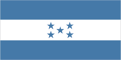
Flag description
three equal horizontal bands of blue (top), white, and blue, with five blue, five-pointed stars arranged in an X pattern centered in the white band; the stars represent the members of the former Federal Republic of Central America - Costa Rica, El Salvador, Guatemala, Honduras, and Nicaragua; the blue bands symbolize the Pacific Ocean and the Caribbean Sea; the white band represents the land between the two bodies of water and the peace and prosperity of its people note: similar to the flag of El Salvador, which features a round emblem encircled by the words REPUBLICA DE EL SALVADOR EN LA AMERICA CENTRAL centered in the white band; also similar to the flag of Nicaragua, which features a triangle encircled by the words REPUBLICA DE NICARAGUA on top and AMERICA CENTRAL on the bottom, centered in the white band
Government type
democratic constitutional republic
Independence
15 September 1821 (from Spain)
International organization participation
BCIE, CACM, FAO, G-11, G-77, IADB, IAEA, IBRD, ICAO, ICCt, ICRM, IDA, IFAD, IFC, IFRCS, ILO, IMF, IMO, Interpol, IOC (suspended), IOM, ISO (subscriber), ITSO, ITU, ITUC, LAES, LAIA (observer), MIGA, MINURSO, NAM, OAS (suspended), OPANAL, OPCW, PCA, PetroCaribe, RG (suspended), SICA, UN, UNCTAD, UNESCO, UNIDO, Union Latina, UNWTO, UPU, WCO (suspended), WFTU, WHO, WIPO, WMO, WTO
Judicial branch
Supreme Court of Justice or Corte Suprema de Justicia (15 judges are elected for seven-year terms by the National Congress)
Legal system
rooted in Roman and Spanish civil law with increasing influence of English common law; recent judicial reforms include abandoning Napoleonic legal codes in favor of the oral adversarial system; accepts ICJ jurisdiction with reservations
Legislative branch
- unicameral National Congress or Congreso Nacional (128 seats; members elected proportionally by department to serve four-year terms)
- election results
- percent of vote by party - NA; seats by party - PNH 71, PL 45, PDC 5, PUD 4, PINU 3
- elections
- last held on 29 November 2009 (next to be held in November 2013)
National anthem
- lyrics/music
- Augusto Constancio COELLO/Carlos HARTLING note: adopted 1915; the anthem's seven verses chronicle Honduran history; on official occasions, only the chorus and last verse are sung
- name
- "Himno Nacional de Honduras" (National Anthem of Honduras)
National holiday
Independence Day, 15 September (1821)
Political parties and leaders
Christian Democratic Party or PDC [Felicito AVILA Ordonez]; Democratic Unification Party or PUD [Cesar HAM]; Liberal Party or PL [Roberto MICHELETTI Bain]; National Party or PN [Antonio ALVAREZ Arias]; Social Democratic Innovation and Unity Party or PINU [Jorge Rafael AGUILAR Paredes]
Political pressure groups and leaders
Beverage and Related Industries Syndicate or STIBYS; Committee for the Defense of Human Rights in Honduras or CODEH; Confederation of Honduran Workers or CTH; Coordinating Committee of Popular Organizations or CCOP; General Workers Confederation or CGT; Honduran Council of Private Enterprise or COHEP; National Association of Honduran Campesinos or ANACH; National Union of Campesinos or UNC; Popular Bloc or BP; United Confederation of Honduran Workers or CUTH
Suffrage
18 years of age; universal and compulsory
Economy
Agriculture - products
bananas, coffee, citrus, corn, African palm; beef; timber; shrimp, tilapia, lobster
Central bank discount rate
NA% (31 December 2009) NA% (31 December 2008)
Commercial bank prime lending rate
19.16% (31 December 2009 est.) 17.94% (31 December 2008 est.)
Current account balance
-$1.048 billion (2010 est.) -$1.327 billion (2009 est.)
Debt - external
$3.54 billion (31 December 2010 est.) $3.311 billion (31 December 2009 est.)
Distribution of family income - Gini index
53.8 (2003) 56.3 (1998)
Economy - overview
Honduras, the second poorest country in Central America, suffers from extraordinarily unequal distribution of income, as well as high underemployment. While historically dependent on the export of bananas and coffee, Honduras has diversified its export base to include apparel and automobile wire harnessing. Nearly half of Honduras's economic activity is directly tied to the US, with exports to the US equivalent to 30% of GDP and remittances for another 20%. The US-Central America Free Trade Agreement (CAFTA) came into force in 2006 and has helped foster foriegn direct investment, but physical and political insecurity may deter potential investors; about 70% of FDI is from US firms. The economy registered marginally positive economic growth in 2010, insufficient to improve living standards for the nearly 60% of the population in poverty. The LOBO administration inherited a difficult fiscal position with off-budget debts accrued in previous administrations and government salaries nearly equivalent to tax collections. His government has displayed a commitment to improving tax collection and cutting expenditures. This enabled Tegucigalpa to secure an IMF Precautionary Stand-By agreement in October 2010. The IMF agreement has helped renew multilateral and bilateral donor confidence in Honduras following the ZELAYA administration's economic mismanagement and the political coup.
Electricity - consumption
6.54 billion kWh note: approximately 1.5 billion kWh in transmission and distribution losses (2009 est.)
Electricity - exports
0 kWh (2008 est.)
Electricity - imports
11.8 million kWh (2007 est.)
Electricity - production
6.58 billion kWh (2009 est.)
Exchange rates
lempiras (HNL) per US dollar - 18.9 (2010), 18.895 (2009), 18.983 (2008), 18.9 (2007), 18.895 (2006)
Exports
$5.879 billion (2010 est.) $5.09 billion (2009 est.)
Exports - commodities
apparel, coffee, shrimp, wire harnessing, cigars, bananas, gold, palm oil, fruit, lobster, lumber
Exports - partners
US 59.6%, El Salvador 5.61%, Guatemala 5.28%, Mexico 4.19%, Germany 4.04% (2009)
GDP - composition by sector
- agriculture
- 12.4%
- industry
- 26.9%
- services
- 60.8% (2010 est.)
GDP - per capita (PPP)
$4,200 (2010 est.) $4,200 (2009 est.) $4,400 (2008 est.) note: data are in 2010 US dollars
GDP - real growth rate
2.5% (2010 est.) -2.1% (2009 est.) 4.2% (2008 est.)
GDP (official exchange rate)
$15.34 billion (2010 est.)
GDP (purchasing power parity)
$33.77 billion (2010 est.) $32.94 billion (2009 est.) $33.65 billion (2008 est.) note: data are in 2010 US dollars
Household income or consumption by percentage share
lowest 10%: 0.7% highest 10%: 42.2% (2006)
Imports
$8.878 billion (2010 est.) $5.924 billion (2009 est.)
Imports - commodities
machinery and transport equipment, industrial raw materials, chemical products, fuels, foodstuffs
Imports - partners
US 46.81%, Guatemala 8.92%, El Salvador 7.13%, Mexico 5.54%, Costa Rica 4.91% (2009)
Industrial production growth rate
2.4% (2010 est.)
Industries
sugar, coffee, woven and knit apparel, wood products, cigars
Inflation rate (consumer prices)
4.6% (2010 est.) 5.5% (2009 est.)
Investment (gross fixed)
23.3% of GDP (2010 est.)
Labor force
3.394 million (2010 est.)
Labor force - by occupation
- agriculture
- 39.2%
- industry
- 20.9%
- services
- 39.8% (2005 est.)
Market value of publicly traded shares
$NA
Natural gas - consumption
0 cu m (2008 est.)
Natural gas - exports
0 cu m (2008 est.)
Natural gas - imports
0 cu m (2008 est.)
Natural gas - production
0 cu m (2008 est.)
Natural gas - proved reserves
0 cu m (1 January 2010 est.)
Oil - consumption
56,000 bbl/day (2009 est.)
Oil - exports
0 bbl/day (2007 est.)
Oil - imports
46,130 bbl/day (2007 est.)
Oil - production
0 bbl/day (2009 est.)
Oil - proved reserves
0 bbl (1 January 2010 est.)
Population below poverty line
65% (2010)
Public debt
26.1% of GDP (2010 est.) 23.7% of GDP (2009 est.)
Reserves of foreign exchange and gold
$2.302 billion (31 December 2010 est.) $2.127 billion (31 December 2009 est.)
Stock of broad money
$7.618 billion (31 December 2010 est.) $7.064 billion (31 December 2009 est.)
Stock of domestic credit
$7.581 billion (31 December 2010 est.) $7.029 billion (31 December 2009 est.)
Stock of narrow money
$1.296 billion (31 December 2010 est) $1.564 billion (31 December 2009 est)
Unemployment rate
5.1% (2010 est.) 3.2% (2009 est.) note: about 36% are unemployed or underemployed
Communications
Broadcast media
multiple privately-owned terrestrial television networks, supplemented by multiple cable TV networks; Radio Honduras is the lone government-owned radio network; roughly 300 privately-owned radio stations (2007)
Internet country code
.hn
Internet hosts
16,075 (2010)
Internet users
731,700 (2009)
Telephone system
- domestic
- beginning in 2003, private sub-operators allowed to provide fixed-lines in order to expand telephone coverage contributing to an increase in fixed-line teledensity to roughly 10 per 100 persons; mobile-cellular subscribership reached 100 per 100 persons in 2009
- general assessment
- the number of fixed-line connections are increasing but still limited; competition among multiple providers of mobile-cellular services is contributing to a sharp increase in the number of subscribers
- international
- country code - 504; landing point for both the Americas Region Caribbean Ring System (ARCOS-1) and the MAYA-1 fiber optic submarine cable system that together provide connectivity to South and Central America, parts of the Caribbean, and the US; satellite earth stations - 2 Intelsat (Atlantic Ocean); connected to Central American Microwave System
Telephones - main lines in use
830,000 (2009)
Telephones - mobile cellular
7.714 million (2009)
Transportation
Airports
104 (2010)
Airports - with paved runways
- total
- 12 2,438 to 3,047 m: 3 1,524 to 2,437 m: 2 914 to 1,523 m: 4 under 914 m: 3 (2010)
Airports - with unpaved runways
- total
- 92 1,524 to 2,437 m: 2 914 to 1,523 m: 16 under 914 m: 74 (2010)
Merchant marine
- by type
- bulk carrier 8, cargo 50, carrier 2, chemical tanker 7, container 1, passenger 3, passenger/cargo 2, petroleum tanker 22, refrigerated cargo 6, roll on/roll off 3
- foreign-owned
- 49 (Bahrain 5, Canada 1, China 2, Egypt 2, Greece 4, Hong Kong 1, Israel 1, Japan 4, Lebanon 2, Mexico 1, Montenegro 2, Panama 1, Singapore 12, South Korea 6, Taiwan 2, Tanzania 1, UK 1, Vietnam 1) (2010)
- total
- 104
Ports and terminals
La Ceiba, Puerto Cortes, San Lorenzo, Tela
Railways
- narrow gauge
- 75 km 1.067-m gauge (2009)
- total
- 75 km
Roadways
- paved
- 3,159 km
- total
- 14,239 km
- unpaved
- 11,080 km (1,420 km summer only) (2009)
Waterways
465 km (most navigable only by small craft) (2010)
Military and Security
Manpower available for military service
males age 16-49: 1,989,556 females age 16-49: 1,939,462 (2010 est.)
Manpower fit for military service
males age 16-49: 1,483,292 females age 16-49: 1,502,788 (2010 est.)
Manpower reaching militarily significant age annually
- female
- 90,757 (2010 est.)
- male
- 94,501
Military branches
Army, Navy (includes Naval Infantry), Honduran Air Force (Fuerza Aerea Hondurena, FAH) (2008)
Military expenditures
0.6% of GDP (2006 est.)
Military service age and obligation
18 years of age for voluntary 2 to 3-year military service (2004)
Transnational Issues
Disputes - international
International Court of Justice (ICJ) ruled on the delimitation of "bolsones" (disputed areas) along the El Salvador-Honduras border in 1992 with final settlement by the parties in 2006 after an Organization of American States (OAS) survey and a further ICJ ruling in 2003; the 1992 ICJ ruling advised a tripartite resolution to a maritime boundary in the Gulf of Fonseca with consideration of Honduran access to the Pacific; El Salvador continues to claim tiny Conejo Island, not mentioned in the ICJ ruling, off Honduras in the Gulf of Fonseca; Honduras claims the Belizean-administered Sapodilla Cays off the coast of Belize in its constitution, but agreed to a joint ecological park around the cays should Guatemala consent to a maritime corridor in the Caribbean under the OAS-sponsored 2002 Belize-Guatemala Differendum; memorials and countermemorials were filed by the parties in Nicaragua's 1999 and 2001 proceedings against Honduras and Colombia at the ICJ over the maritime boundary and territorial claims in the western Caribbean Sea - final public hearings are scheduled for 2007
Illicit drugs
transshipment point for drugs and narcotics; illicit producer of cannabis, cultivated on small plots and used principally for local consumption; corruption is a major problem; some money-laundering activity page last updated on January 19, 2011 ======================================================================