2011 Edition
CIA World Factbook 2011 Archive (HTML)
Introduction
Background
The Mayan civilization flourished in Guatemala and surrounding regions during the first millennium A.D. After almost three centuries as a Spanish colony, Guatemala won its independence in 1821. During the second half of the 20th century, it experienced a variety of military and civilian governments, as well as a 36-year guerrilla war. In 1996, the government signed a peace agreement formally ending the conflict, which had left more than 100,000 people dead and had created, by some estimates, some 1 million refugees.
Geography
Area
- 108,889 sq km 107,159 sq km 1,730 sq km
- total
- 108,889 sq km
- water
- 1,730 sq km
Area - comparative
slightly smaller than Tennessee
Climate
tropical; hot, humid in lowlands; cooler in highlands
Coastline
400 km
Elevation extremes
- Pacific Ocean 0 m Volcan Tajumulco 4,211 m highest point in Central America
- highest point
- Volcan Tajumulco 4,211 m
- lowest point
- Pacific Ocean 0 m
Environment - current issues
deforestation in the Peten rainforest; soil erosion; water pollution
Environment - international agreements
- Antarctic Treaty, Biodiversity, Climate Change, Climate Change-Kyoto Protocol, Desertification, Endangered Species, Environmental Modification, Hazardous Wastes, Law of the Sea, Marine Dumping, Ozone Layer Protection, Ship Pollution, Wetlands, Whaling none of the selected agreements
- party to
- Antarctic Treaty, Biodiversity, Climate Change, Climate Change-Kyoto Protocol, Desertification, Endangered Species, Environmental Modification, Hazardous Wastes, Law of the Sea, Marine Dumping, Ozone Layer Protection, Ship Pollution, Wetlands, Whaling
- signed, but not ratified
- none of the selected agreements
Freshwater withdrawal (domestic/industrial/agricultural)
- 2.01 cu km/yr (6%/13%/80%) 160 cu m/yr (2000)
- per capita
- 160 cu m/yr (2000)
- total
- 2.01 cu km/yr (6%/13%/80%)
Geographic coordinates
15 30 N, 90 15 W
Geography - note
no natural harbors on west coast
Irrigated land
2,000 sq km (2008)
Land boundaries
- 1,687 km Belize 266 km, El Salvador 203 km, Honduras 256 km, Mexico 962 km
- border countries
- Belize 266 km, El Salvador 203 km, Honduras 256 km, Mexico 962 km
- total
- 1,687 km
Land use
- 13.22% 5.6% 81.18% (2005)
- arable land
- 13.22%
- other
- 81.18% (2005)
- permanent crops
- 5.6%
Location
Central America, bordering the North Pacific Ocean, between El Salvador and Mexico, and bordering the Gulf of Honduras (Caribbean Sea) between Honduras and Belize
Map references
Central America and the Caribbean
Maritime claims
- 12 nm 200 nm 200 m depth or to the depth of exploitation
- continental shelf
- 200 m depth or to the depth of exploitation
- exclusive economic zone
- 200 nm
- territorial sea
- 12 nm
Natural hazards
- numerous volcanoes in mountains, with occasional violent earthquakes; Caribbean coast extremely susceptible to hurricanes and other tropical storms Guatemala experiences significant volcanic activity in the Sierra Madre range; Santa Maria (elev. 3,772 m) has been deemed a "Decade Volcano" by the International Association of Volcanology and Chemistry of the Earth's Interior, worthy of study due to its explosive history and close proximity to human populations; Pacaya (elev. 2,552 m), which erupted in May 2010 causing an ashfall on Guatemala City and prompting evacuations, is one of the country's most active volcanoes; the volcano has frequently been in eruption since 1965; other historically active volcanoes include Acatenango, Almolonga, Atitlan, Fuego, and Tacana
- volcanism
- Guatemala experiences significant volcanic activity in the Sierra Madre range; Santa Maria (elev. 3,772 m) has been deemed a "Decade Volcano" by the International Association of Volcanology and Chemistry of the Earth's Interior, worthy of study due to its explosive history and close proximity to human populations; Pacaya (elev. 2,552 m), which erupted in May 2010 causing an ashfall on Guatemala City and prompting evacuations, is one of the country's most active volcanoes; the volcano has frequently been in eruption since 1965; other historically active volcanoes include Acatenango, Almolonga, Atitlan, Fuego, and Tacana
Natural resources
petroleum, nickel, rare woods, fish, chicle, hydropower
Terrain
mostly mountains with narrow coastal plains and rolling limestone plateau
Total renewable water resources
111.3 cu km (2000)
People and Society
Age structure
- 38.1% (male 2,678,340/female 2,582,472) 58% (male 3,889,573/female 4,130,698) 3.9% (male 252,108/female 291,272) (2011 est.)
- 0-14 years
- 38.1% (male 2,678,340/female 2,582,472)
- 15-64 years
- 58% (male 3,889,573/female 4,130,698)
- 65 years and over
- 3.9% (male 252,108/female 291,272) (2011 est.)
Birth rate
26.96 births/1,000 population (2011 est.)
Children under the age of 5 years underweight
17.7% (2002)
Death rate
4.98 deaths/1,000 population (July 2011 est.)
Drinking water source
- urban: 98% of population rural: 90% of population total: 94% of population urban: 2% of population rural: 10% of population total: 6% of population (2008)
- rural
- 10% of population
- total
- 6% of population (2008)
- urban
- 2% of population
Education expenditures
3.2% of GDP (2008)
Ethnic groups
Mestizo (mixed Amerindian-Spanish - in local Spanish called Ladino) and European 59.4%, K'iche 9.1%, Kaqchikel 8.4%, Mam 7.9%, Q'eqchi 6.3%, other Mayan 8.6%, indigenous non-Mayan 0.2%, other 0.1% (2001 census)
Health expenditures
5.7% of GDP (2009)
HIV/AIDS - adult prevalence rate
0.8% (2009 est.)
HIV/AIDS - deaths
2,600 (2009 est.)
HIV/AIDS - people living with HIV/AIDS
62,000 (2009 est.)
Hospital bed density
0.6 beds/1,000 population (2009)
Infant mortality rate
- 26.02 deaths/1,000 live births 28.26 deaths/1,000 live births 23.67 deaths/1,000 live births (2011 est.)
- female
- 23.67 deaths/1,000 live births (2011 est.)
- total
- 26.02 deaths/1,000 live births
Languages
Spanish (official) 60%, Amerindian languages 40% there are 23 officially recognized Amerindian languages, including Quiche, Cakchiquel, Kekchi, Mam, Garifuna, and Xinca
Life expectancy at birth
- 70.88 years 69.03 years 72.83 years (2011 est.)
- female
- 72.83 years (2011 est.)
- total population
- 70.88 years
Literacy
- age 15 and over can read and write 69.1% 75.4% 63.3% (2002 census)
- definition
- age 15 and over can read and write
- female
- 63.3% (2002 census)
- male
- 75.4%
- total population
- 69.1%
Major cities - population
GUATEMALA CITY (capital) 1.075 million (2009)
Major infectious diseases
- high bacterial diarrhea, hepatitis A, and typhoid fever dengue fever and malaria leptospirosis (2009)
- degree of risk
- high
- food or waterborne diseases
- bacterial diarrhea, hepatitis A, and typhoid fever
- vectorborne disease
- dengue fever and malaria
- water contact disease
- leptospirosis (2009)
Maternal mortality rate
110 deaths/100,000 live births (2008)
Median age
- 20 years 19.4 years 20.7 years (2011 est.)
- female
- 20.7 years (2011 est.)
- male
- 19.4 years
- total
- 20 years
Nationality
- Guatemalan(s) Guatemalan
- adjective
- Guatemalan
- noun
- Guatemalan(s)
Net migration rate
-2.12 migrant(s)/1,000 population (2011 est.)
Physicians density
0.9 physicians/1,000 population (1999)
Population
13,824,463 (July 2011 est.)
Population growth rate
1.986% (2011 est.)
Religions
Roman Catholic, Protestant, indigenous Mayan beliefs
Sanitation facility access
- urban: 89% of population rural: 73% of population total: 81% of population urban: 11% of population rural: 27% of population total: 19% of population (2008)
- rural
- 27% of population
- total
- 19% of population (2008)
- urban
- 11% of population
School life expectancy (primary to tertiary education)
- 11 years 11 years 10 years (2007)
- female
- 10 years (2007)
- male
- 11 years
- total
- 11 years
Sex ratio
- 1.05 male(s)/female 1.04 male(s)/female 0.94 male(s)/female 0.86 male(s)/female 0.97 male(s)/female (2011 est.)
- 15-64 years
- 0.94 male(s)/female
- 65 years and over
- 0.86 male(s)/female
- at birth
- 1.05 male(s)/female
- total population
- 0.97 male(s)/female (2011 est.)
- under 15 years
- 1.04 male(s)/female
Total fertility rate
3.27 children born/woman (2011 est.)
Urbanization
- 49% of total population (2010) 3.4% annual rate of change (2010-15 est.)
- rate of urbanization
- 3.4% annual rate of change (2010-15 est.)
- urban population
- 49% of total population (2010)
Government
Administrative divisions
22 departments (departamentos, singular - departamento); Alta Verapaz, Baja Verapaz, Chimaltenango, Chiquimula, El Progreso, Escuintla, Guatemala, Huehuetenango, Izabal, Jalapa, Jutiapa, Peten, Quetzaltenango, Quiche, Retalhuleu, Sacatepequez, San Marcos, Santa Rosa, Solola, Suchitepequez, Totonicapan, Zacapa
Capital
- Guatemala City 14 37 N, 90 31 W UTC-6 (1 hour behind Washington, DC during Standard Time)
- geographic coordinates
- 14 37 N, 90 31 W
- name
- Guatemala City
- time difference
- UTC-6 (1 hour behind Washington, DC during Standard Time)
Constitution
31 May 1985, effective 14 January 1986; suspended 25 May 1993; reinstated 5 June 1993; amended November 1993
Country name
- Republic of Guatemala Guatemala Republica de Guatemala Guatemala
- conventional long form
- Republic of Guatemala
- conventional short form
- Guatemala
- local long form
- Republica de Guatemala
- local short form
- Guatemala
Diplomatic representation from the US
- Ambassador Stephen G. MCFARLAND 7-01 Avenida Reforma, Zone 10, Guatemala City APO AA 34024 [502] 2326-4000 [502] 2326-4654
- chief of mission
- Ambassador Stephen G. MCFARLAND
- embassy
- 7-01 Avenida Reforma, Zone 10, Guatemala City
- FAX
- [502] 2326-4654
- mailing address
- APO AA 34024
- telephone
- [502] 2326-4000
Diplomatic representation in the US
- Ambassador Julio Armando MARTINI Herrera 2220 R Street NW, Washington, DC 20008 [1] (202) 745-4952 [1] (202) 745-1908 Atlanta, Chicago, Denver, Houston, Los Angeles, Miami, New York, Phoenix, Providence, San Francisco
- chancery
- 2220 R Street NW, Washington, DC 20008
- chief of mission
- Ambassador Julio Armando MARTINI Herrera
- consulate(s) general
- Atlanta, Chicago, Denver, Houston, Los Angeles, Miami, New York, Phoenix, Providence, San Francisco
- FAX
- [1] (202) 745-1908
- telephone
- [1] (202) 745-4952
Executive branch
- President Alvaro COLOM Caballeros (since 14 January 2008); Vice President Jose Rafael ESPADA (since 14 January 2008); note - the president is both the chief of state and head of government President Alvaro COLOM Caballeros (since 14 January 2008); Vice President Jose Rafael ESPADA (since 14 January 2008) Council of Ministers appointed by the president president and vice president elected on the same ticket by popular vote for a four-year term (may not serve consecutive terms); election last held on 9 September 2007; runoff held on 4 November 2007 (next to be held in September 2011) Otto PEREZ Molina elected president in a runoff election; percent of vote - Otto PEREZ Molina 53.7%, Manuel BALDIZON 47.2%; note - Otto PEREZ Molina will take office on 14 January 2012
- cabinet
- Council of Ministers appointed by the president
- chief of state
- President Alvaro COLOM Caballeros (since 14 January 2008); Vice President Jose Rafael ESPADA (since 14 January 2008); note - the president is both the chief of state and head of government
- election results
- Otto PEREZ Molina elected president in a runoff election; percent of vote - Otto PEREZ Molina 53.7%, Manuel BALDIZON 47.2%; note - Otto PEREZ Molina will take office on 14 January 2012
- elections
- president and vice president elected on the same ticket by popular vote for a four-year term (may not serve consecutive terms); election last held on 9 September 2007; runoff held on 4 November 2007 (next to be held in September 2011)
- head of government
- President Alvaro COLOM Caballeros (since 14 January 2008); Vice President Jose Rafael ESPADA (since 14 January 2008)
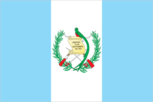
Flag description
three equal vertical bands of light blue (hoist side), white, and light blue, with the coat of arms centered in the white band; the coat of arms includes a green and red quetzal (the national bird) representing liberty and a scroll bearing the inscription LIBERTAD 15 DE SEPTIEMBRE DE 1821 (the original date of independence from Spain) all superimposed on a pair of crossed rifles signifying Guatemala's willingness to defend itself and a pair of crossed swords representing honor and framed by a laurel wreath symbolizing victory; the blue bands stand for the Pacific Ocean and the Caribbean Sea and the sea and sky; the white band denotes peace and purity
Government type
constitutional democratic republic
Independence
15 September 1821 (from Spain)
International law organization participation
has not submitted an ICJ jurisdiction declaration; non-party state to the ICCt
International organization participation
BCIE, CACM, FAO, G-24, G-77, IADB, IAEA, IBRD, ICAO, ICC, ICRM, IDA, IFAD, IFC, IFRCS, IHO, ILO, IMF, IMO, Interpol, IOC, IOM, IPU, ISO (correspondent), ITSO, ITU, ITUC, LAES, LAIA (observer), MIGA, MINUSTAH, MONUSCO, NAM, OAS, OPANAL, OPCW, PCA, PetroCaribe, RG, SICA, UN, UNAMID, UNCTAD, UNESCO, UNIDO, UNIFIL, Union Latina, UNISFA, UNITAR, UNMISS, UNOCI, UNWTO, UPU, WCO, WFTU, WHO, WIPO, WMO, WTO
Judicial branch
Constitutional Court or Corte de Constitucionalidad is Guatemala's highest court (five judges are elected by Congress for concurrent five-year terms); Supreme Court of Justice or Corte Suprema de Justicia (13 members are elected by Congress to serve concurrent five-year terms and elect a president of the Court each year from among their number; the president of the Supreme Court of Justice also supervises trial judges around the country, who are named to five-year terms)
Legal system
civil law system; judicial review of legislative acts
Legislative branch
- unicameral Congress of the Republic or Congreso de la Republica (158 seats; members elected through a party list proportional representation system) last held on 9 September 2007 (next to be held in September 2011) percent of vote by party - UNE 30.4%, GANA 23.4%, PP 18.9%, FRG 9.5%, PU 5.1%, other 12.7%; seats by party - UNE 48, GANA 37, PP 30, FRG 15, PU 8, CASA 5, EG 4, PAN 4, UCN 4, URNG 2, UD 1
- election results
- percent of vote by party - UNE 30.4%, GANA 23.4%, PP 18.9%, FRG 9.5%, PU 5.1%, other 12.7%; seats by party - UNE 48, GANA 37, PP 30, FRG 15, PU 8, CASA 5, EG 4, PAN 4, UCN 4, URNG 2, UD 1
- elections
- last held on 9 September 2007 (next to be held in September 2011)
National anthem
- "Himno Nacional de Guatemala" (National Anthem of Guatemala) Jose Joaquin PALMA/Rafael Alvarez OVALLE adopted 1897, modified lyrics adopted 1934; Cuban poet Jose Joaquin PALMA anonymously submitted lyrics to a public contest calling for a national anthem; his authorship was not discovered until 1911
- lyrics/music
- Jose Joaquin PALMA/Rafael Alvarez OVALLE
- name
- "Himno Nacional de Guatemala" (National Anthem of Guatemala)
National holiday
Independence Day, 15 September (1821)
National symbol(s)
quetzal (bird)
Political parties and leaders
Center of Social Action or CASA [Feliz Adolfo RUANO de Leon]; Democracy Front or FRENTE [Alfonso CABRERA]; Democratic Union or UD [Edwin Armando MARTINEZ Herrera]; Encounter for Guatemala or EG [Nineth MONTENGRO]; Grand National Alliance or GANA [Jaime Antonio MARTINEZ Lohayza]; Guatemalan National Revolutionary Unity or URNG [Hector Alfredo NUILA Ericastilla]; Guatemalan Republican Front or FRG [Luis Fernando PEREZ]; Independent Bloc Guatemala or BG [Macario Efrain OLIVA Muralles]; Independent Democratic Freedom Renewed or LIDER [Manuel BALDIZON]; National Advancement Party or PAN [Juan GUTIERREZ]; National Unity for Hope or UNE [Roberto KESTLER Velasquez]; Nationalist Change Union or UCN [Mario ESTRADA]; Patriot Party or PP [Ingrid Roxana BALDETTI Elias]; Unionista Party or PU [Alvaro ARZU Irigoyen]
Political pressure groups and leaders
Agrarian Owners Group or UNAGRO; Alliance Against Impunity or AAI; Committee for Campesino Unity or CUC; Coordinating Committee of Agricultural, Commercial, Industrial, and Financial Associations or CACIF; International Commission Against Impunity in Guatemala or CICIG; Mutual Support Group or GAM
Suffrage
18 years of age; universal; note - active duty members of the armed forces may not vote and are restricted to their barracks on election day
Economy
Agriculture - products
sugarcane, corn, bananas, coffee, beans, cardamom; cattle, sheep, pigs, chickens
Budget
- $4.644 billion $6.005 billion (2010 est.)
- expenditures
- $6.005 billion (2010 est.)
- revenues
- $4.644 billion
Budget surplus (+) or deficit (-)
-3.3% of GDP (2010 est.)
Central bank discount rate
6.5% (31 December 2010 est.) NA% (31 December 2009 est.)
Commercial bank prime lending rate
13.34% (31 December 2010 est.) 13.85% (31 December 2009 est.)
Current account balance
-$878.3 million (2010 est.) -$51.8 million (2009 est.)
Debt - external
$15.75 billion (31 December 2010 est.) $13.8 billion (31 December 2009 est.)
Distribution of family income - Gini index
55.1 (2007) 55.8 (1998)
Economy - overview
Guatemala is the most populous country in Central America with a GDP per capita roughly one-half that of the average for Latin America and the Caribbean. The agricultural sector accounts for nearly 15% of GDP and half of the labor force; key agricultural exports include coffee, sugar, and bananas. The 1996 peace accords, which ended 36 years of civil war, removed a major obstacle to foreign investment, and since then Guatemala has pursued important reforms and macroeconomic stabilization. The Dominican Republic-Central American Free Trade Agreement (CAFTA-DR) entered into force in July 2006 spurring increased investment and diversification of exports, with the largest increases in ethanol and non-traditional agricultural exports. While CAFTA-DR has helped improve the investment climate, concerns over security, the lack of skilled workers and poor infrastructure continue to hamper foreign direct investment. The distribution of income remains highly unequal with the richest 10% of the population accounting for more than 40% of Guatemala's overall consumption. More than half of the population is below the national poverty line and 15% lives in extreme poverty. Poverty among indigenous groups, which make up 38% of the population, averages 76% and extreme poverty rises to 28%. 43% of children under five are chronically malnourished, one of the highest malnutrition rates in the world. President COLOM entered into office with the promise to increase education, healthcare, and rural development, and in April 2008 he inaugurated a conditional cash transfer program, modeled after programs in Brazil and Mexico, that provide financial incentives for poor families to keep their children in school and get regular health check-ups. Given Guatemala's large expatriate community in the United States, it is the top remittance recipient in Central America, with inflows serving as a primary source of foreign income equivalent to nearly two-thirds of exports or one-tenth of GDP. Economic growth fell in 2009 as export demand from US and other Central American markets fell and foreign investment slowed amid the global recession, but the economy recovered gradually in 2010 and will likely return to more normal growth rates by 2012. President COLOM, in his last year in office, will likely face opposition to economic reform, particularly over a long-delayed tax reform and an IMF-recommended reform to strengthen the banking sector.
Electricity - consumption
7.108 billion kWh (2008 est.)
Electricity - exports
76 million kWh (2008 est.)
Electricity - imports
71 million kWh (2008 est.)
Electricity - production
8.395 billion kWh (2008 est.)
Exchange rates
quetzales (GTQ) per US dollar - 8.0798 (2010) 8.1616 (2009) 7.5895 (2008) 7.6833 (2007) 7.6026 (2006)
Exports
$8.566 billion (2010 est.) $7.295 billion (2009 est.)
Exports - commodities
coffee, sugar, petroleum, apparel, bananas, fruits and vegetables, cardamom
Exports - partners
US 36.8%, El Salvador 10.3%, Honduras 8.8%, Mexico 7.5% (2010)
GDP - composition by sector
- 13.2% 23.8% 63% (2010 est.)
- agriculture
- 13.2%
- industry
- 23.8%
- services
- 63% (2010 est.)
GDP - per capita (PPP)
$5,200 (2010 est.) $5,100 (2009 est.) $5,200 (2008 est.) data are in 2010 US dollars
GDP - real growth rate
2.6% (2010 est.) 0.5% (2009 est.) 3.3% (2008 est.)
GDP (official exchange rate)
$41.47 billion (2010 est.)
GDP (purchasing power parity)
$70.15 billion (2010 est.) $68.36 billion (2009 est.) $68 billion (2008 est.) data are in 2010 US dollars
Household income or consumption by percentage share
- 1.3% 42.4% (2006)
- highest 10%
- 42.4% (2006)
- lowest 10%
- 1.3%
Imports
$12.86 billion (2010 est.) $10.64 billion (2009 est.)
Imports - commodities
fuels, machinery and transport equipment, construction materials, grain, fertilizers, electricity
Imports - partners
US 34.6%, Mexico 11.8%, China 7.9%, El Salvador 5.3% (2010)
Industrial production growth rate
3.2% (2010 est.)
Industries
sugar, textiles and clothing, furniture, chemicals, petroleum, metals, rubber, tourism
Inflation rate (consumer prices)
3.9% (2010 est.) 1.9% (2009 est.)
Investment (gross fixed)
15.2% of GDP (2010 est.)
Labor force
4.146 million (2010 est.)
Labor force - by occupation
- 50% 15% 35% (1999 est.)
- agriculture
- 50%
- industry
- 15%
- services
- 35% (1999 est.)
Market value of publicly traded shares
$NA
Natural gas - consumption
0 cu m (2009 est.)
Natural gas - exports
0 cu m (2009 est.)
Natural gas - imports
0 cu m (2009 est.)
Natural gas - production
0 cu m (2009 est.)
Natural gas - proved reserves
2.96 billion cu m (1 January 2006 est.)
Oil - consumption
71,000 bbl/day (2010 est.)
Oil - exports
15,300 bbl/day (2009 est.)
Oil - imports
78,550 bbl/day (2009 est.)
Oil - production
13,070 bbl/day (2010 est.)
Oil - proved reserves
83.07 million bbl (1 January 2011 est.)
Population below poverty line
56.2% (2004 est.)
Public debt
29.7% of GDP (2010 est.) 28.2% of GDP (2009 est.)
Reserves of foreign exchange and gold
$5.646 billion (31 December 2010 est.) $4.973 billion (31 December 2009 est.)
Stock of broad money
$25.54 billion (31 December 2010 est.) $22.39 billion (31 December 2009 est.)
Stock of domestic credit
$15.94 billion (31 December 2010 est.) $14.47 billion (31 December 2009 est.)
Stock of narrow money
$6.806 billion (31 December 2010 est.) $5.994 billion (31 December 2009 est.)
Taxes and other revenues
11.2% of GDP (2010 est.)
Unemployment rate
3.2% (2005 est.)
Communications
Broadcast media
4 privately-owned national terrestrial TV channels dominate TV broadcasting; multi-channel satellite and cable services are available; 1 government-owned radio station and hundreds of privately-owned radio stations (2007)
Internet country code
.gt
Internet hosts
196,870 (2010)
Internet users
2.279 million (2009)
Telephone system
- fairly modern network centered in the city of Guatemala state-owned telecommunications company privatized in the late 1990s opening the way for competition; fixed-line teledensity roughly 10 per 100 persons; fixed-line investments are being concentrated on improving rural connectivity; mobile-cellular teledensity exceeds 100 per 100 persons country code - 502; landing point for both the Americas Region Caribbean Ring System (ARCOS-1) and the SAM-1 fiber optic submarine cable system that together provide connectivity to South and Central America, parts of the Caribbean, and the US; connected to Central American Microwave System; satellite earth station - 1 Intelsat (Atlantic Ocean) (2008)
- domestic
- state-owned telecommunications company privatized in the late 1990s opening the way for competition; fixed-line teledensity roughly 10 per 100 persons; fixed-line investments are being concentrated on improving rural connectivity; mobile-cellular teledensity exceeds 100 per 100 persons
- general assessment
- fairly modern network centered in the city of Guatemala
- international
- country code - 502; landing point for both the Americas Region Caribbean Ring System (ARCOS-1) and the SAM-1 fiber optic submarine cable system that together provide connectivity to South and Central America, parts of the Caribbean, and the US; connected to Central American Microwave System; satellite earth station - 1 Intelsat (Atlantic Ocean) (2008)
Telephones - main lines in use
1.499 million (2010)
Telephones - mobile cellular
18.068 million (2010)
Transportation
Airports
372 (2010)
Airports - with paved runways
- 3 (2010)
- 1,524 to 2,437 m
- 3
- 2,438 to 3,047 m
- 3
- 914 to 1,523 m
- 4
- total
- 13
- under 914 m
- 3 (2010)
Airports - with unpaved runways
- 271 (2010)
- 1,524 to 2,437 m
- 3
- 2,438 to 3,047 m
- 1
- 914 to 1,523 m
- 84
- total
- 359
- under 914 m
- 271 (2010)
Pipelines
oil 480 km (2010)
Ports and terminals
Puerto Quetzal, Santo Tomas de Castilla
Railways
- 332 km 332 km 0.914-m gauge (2009)
- total
- 332 km
Roadways
- 14,095 km 4,863 km (includes 75 km of expressways) 9,232 km (2001)
- total
- 14,095 km
- unpaved
- 9,232 km (2001)
Waterways
990 km (260 km navigable year round; additional 730 km navigable during high-water season) (2010)
Military and Security
Manpower available for military service
- 3,165,870 3,371,217 (2010 est.)
- females age 16-49
- 3,371,217 (2010 est.)
- males age 16-49
- 3,165,870
Manpower fit for military service
- 2,590,843 2,926,544 (2010 est.)
- females age 16-49
- 2,926,544 (2010 est.)
- males age 16-49
- 2,590,843
Manpower reaching militarily significant age annually
- 171,092 168,151 (2010 est.)
- female
- 168,151 (2010 est.)
- male
- 171,092
Military branches
National Army of Guatemala (Ejercito Nacional de Guatemala, ENG), Guatemalan Navy (Marina Nacional, includes Marines), Guatemalan Air Force (Fuerza Aerea Guatemalteca, FAG) (2009)
Military expenditures
0.4% of GDP (2009)
Military service age and obligation
all male citizens between the ages of 18 and 50 are liable for military service; conscript service obligation varies from 12 to 24 months; women can serve as officers (2009)
Transnational Issues
Disputes - international
annual ministerial meetings under the OAS-initiated Agreement on the Framework for Negotiations and Confidence Building Measures continue to address Guatemalan land and maritime claims in Belize and the Caribbean Sea; Guatemala persists in its territorial claim to half of Belize, but agrees to Line of Adjacency to keep Guatemalan squatters out of Belize's forested interior; Mexico must deal with thousands of impoverished Guatemalans and other Central Americans who cross the porous border looking for work in Mexico and the United States
Illicit drugs
major transit country for cocaine and heroin; in 2005, cultivated 100 hectares of opium poppy after reemerging as a potential source of opium in 2004; potential production of less than 1 metric ton of pure heroin; marijuana cultivation for mostly domestic consumption; proximity to Mexico makes Guatemala a major staging area for drugs (particularly for cocaine); money laundering is a serious problem; corruption is a major problem
Refugees and internally displaced persons
- undetermined (the UN does not estimate there are any IDPs, although some NGOs estimate over 200,000 IDPs as a result of over three decades of internal conflict that ended in 1996) (2007)
- IDPs
- undetermined (the UN does not estimate there are any IDPs, although some NGOs estimate over 200,000 IDPs as a result of over three decades of internal conflict that ended in 1996) (2007)