1996 Edition
CIA World Factbook 1996 (Project Gutenberg)
Introduction
Description
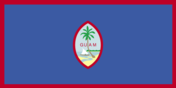
territorial flag is dark blue with a narrow red border on all four sides; centered is a red-bordered, pointed, vertical ellipse containing a beach scene, outrigger canoe with sail, and a palm tree with the word GUAM superimposed in bold red letters; US flag is the national flag
Location
13 28 N, 144 47 E -- Oceania, island in the North Pacific Ocean, about three-quarters of the way from Hawaii to the Philippines Flag ----
Geography
Area
- comparative area
- three times the size of Washington, DC
- land area
- 541.3 sq km
- total area
- 541.3 sq km
Climate
tropical marine; generally warm and humid, moderated by northeast trade winds; dry season from January to June, rainy season from July to December; little seasonal temperature variation
Coastline
125.5 km
Environment
- current issues
- NA
- international agreements
- NA
- natural hazards
- frequent squalls during rainy season; relatively rare, but potentially very destructive typhoons (especially in August)
Geographic coordinates
13 28 N, 144 47 E
Geographic note
largest and southernmost island in the Mariana Islands archipelago; strategic location in western North Pacific Ocean
International disputes
none
Irrigated land
NA sq km
Land boundaries
0 km
Land use
- arable land
- 11%
- forest and woodland
- 18%
- meadows and pastures
- 15%
- other
- 45%
- permanent crops
- 11%
Location
Oceania, island in the North Pacific Ocean, about three-quarters of the way from Hawaii to the Philippines
Map references
Oceania
Maritime claims
- exclusive economic zone
- 200 nm
- territorial sea
- 12 nm
Natural resources
fishing (largely undeveloped), tourism (especially from Japan)
Terrain
- volcanic origin, surrounded by coral reefs; relatively flat coralline limestone plateau (source of most fresh water) with steep coastal cliffs and narrow coastal plains in north, low-rising hills in center, mountains in south
- highest point
- Mount Lamlam 406 m
- lowest point
- Pacific Ocean 0 m
People and Society
Age structure
0-14 years: NA 15-64 years: NA 65 years and over: NA
Birth rate
24.24 births/1,000 population (1996 est.)
Death rate
3.86 deaths/1,000 population (1996 est.)
Ethnic divisions
Chamorro 47%, Filipino 25%, white 10%, Chinese, Japanese, Korean, and other 18%
Infant mortality rate
15.17 deaths/1,000 live births (1996 est.)
Languages
English, Chamorro, Japanese
Life expectancy at birth
- female
- 76.13 years (1996 est.)
- male
- 72.42 years
- total population
- 74.29 years
Literacy
- age 15 and over can read and write (1990 est.)
- female
- 99%
- male
- 99%
- total population
- 99%
Nationality
- adjective
- Guamanian
- noun
- Guamanian(s)
Net migration rate
3 migrant(s)/1,000 population (1996 est.)
Population
156,974 (July 1996 est.)
Population growth rate
2.34% (1996 est.)
Religions
Roman Catholic 98%, other 2%
Sex ratio
- all ages
- NA male(s)/female
- at birth
- NA male(s)/female
- under 15 years
- NA male(s)/female 15-64 years: NA male(s)/female 65 years and over: NA male(s)/female
Total fertility rate
2.25 children born/woman (1996 est.)
Government
Administrative divisions
none (territory of the US)
Capital
Agana
Constitution
Organic Act of 1 August 1950
Data code
GQ
Diplomatic representation in US
none (territory of the US)
Executive branch
- cabinet
- executive departments; heads appointed by the governor with the consent of the Guam legislature
- chief of state
- President (of the United States) William Jefferson CLINTON (since 20 January 1993); Vice President Albert GORE, Jr. (since 20 January 1993)
- head of government
- Governor Carl GUTIERREZ (since 8 November 1994) and Lieutenant Governor Madeleine BORDALLO (since 8 November 1994) were elected for a four-year term by popular vote; election last held 8 November 1994 (next to be held NA November 1998); results - Carl GUTIERREZ (Democrat) defeated Tommy TANAKA (Republican) with 54.6% of the vote
Flag
territorial flag is dark blue with a narrow red border on all four sides; centered is a red-bordered, pointed, vertical ellipse containing a beach scene, outrigger canoe with sail, and a palm tree with the word GUAM superimposed in bold red letters; US flag is the national flag
Independence
none (territory of the US)
International organization participation
ESCAP (associate), IOC, SPC
Judicial branch
Federal District Court, judge is appointed by the president; Territorial Superior Court, judges appointed for eight-year terms by the governor
Legal system
modeled on US; federal laws apply
Legislative branch
unicameral
Legislature
elections last held 8 November 1994 (next to be held NA November 1996); results - percent of vote by party NA; seats - (21 total) Democrats 14, Republican 7
Name of country
- conventional long form
- Territory of Guam
- conventional short form
- Guam
National holiday
Guam Discovery Day (first Monday in March) (1521); Liberation Day, 21 July
Political parties and leaders
Democratic Party (controls the legislature); Republican Party (party of the Governor)
Suffrage
18 years of age; universal; US citizens, but do not vote in US presidential elections
Type of government
organized, unincorporated territory of the US with policy relations between Guam and the US under the jurisdiction of the Office of Territorial and International Affairs, US Department of the Interior
US diplomatic representation
none (territory of the US)
US House of Representatives
elections last held 8 November 1994 (next to be held NA November 1996); Guam elects one delegate; results - Robert UNDERWOOD was reelected as delegate; seats - (1 total) Democrat 1
Economy
Agriculture
fruits, copra, vegetables; eggs, pork, poultry, beef
Budget
- expenditures
- $395 million, including capital expenditures of $NA (1991)
- revenues
- $525 million
Currency
1 United States dollar (US$) = 100 cents
Economic aid
- recipient
- although Guam receives no foreign aid, it does receive large transfer payments from the general revenues of the US Federal Treasury into which Guamanians pay no income or excise taxes; under the provisions of a special law of Congress, the Guamanian Treasury, rather than the US Treasury, receives federal income taxes paid by military and civilian Federal employees stationed in Guam
Economic overview
The economy depends mainly on US military spending and on revenues from tourism. Over the past 20 years, the tourist industry has grown rapidly, creating a construction boom for new hotels and the expansion of older ones. Visitors numbered about 900,000 in 1992. The slowdown in Japanese economic growth has been reflected in less vigorous growth in the tourism sector. About 60% of the labor force works for the private sector and the rest for government. Most food and industrial goods are imported, with about 75% from the US. Guam faces the problem of building up the civilian economic sector to offset the impact of military downsizing.
Electricity
- capacity
- 300,000 kW
- consumption per capita
- 4,797 kWh (1993)
- production
- 750 million kWh
Exchange rates
US currency is used
Exports
- $34 million (f.o.b., 1984)
- commodities
- mostly transshipments of refined petroleum products, construction materials, fish, food and beverage products
- partners
- US 25%, Trust Territory of the Pacific Islands 63%, other 12%
External debt
$NA
Fiscal year
1 October - 30 September
GDP
purchasing power parity - $2 billion (1991 est.)
GDP composition by sector
- agriculture
- NA%
- industry
- NA%
- services
- NA%
GDP per capita
$14,000 (1991 est.)
GDP real growth rate
NA%
Imports
- $493 million (c.i.f., 1984)
- commodities
- petroleum and petroleum products, food, manufactured goods
- partners
- US 23%, Japan 19%, other 58%
Industrial production growth rate
NA%
Industries
US military, tourism, construction, transshipment services, concrete products, printing and publishing, food processing, textiles
Inflation rate (consumer prices)
4% (1992 est.)
Labor force
- 46,930 (1990)
- by occupation
- federal and territorial government 40%, private 60% (trade 18%, services 15.6%, construction 13.8%, other 12.6%) (1990)
Unemployment rate
2% (1992 est.)
Communications
Defense note
defense is the responsibility of the US
Radio broadcast stations
AM 3, FM 3, shortwave 0
Radios
NA
Telephone system
- domestic
- NA
- international
- satellite earth stations - 2 Intelsat (Pacific Ocean); submarine cables to US and Japan
Telephones
26,317 (1989 est.)
Television broadcast stations
3
Televisions
75,000 (1993 est.) Defense
Transportation
Airports
- total
- 4
- with paved runways 2 438 to 3 047 m
- 1
- with paved runways over 3 047 m
- 2
- with paved runways under 914 m
- 1 (1995 est.)
Highways
- paved
- NA km
- total
- 674 km (all-weather roads)
- unpaved
- NA km
Merchant marine
none
Ports
Apra Harbor
Railways
0 km