2025 Edition Primary
Edition Builder
Introduction
Background
The Faroe Islands were already populated by about A.D. 500, but whether the original settlers were Celtic or early Norse (or someone else) has yet to be determined. Viking settlers arrived on the islands in the 9th century, and the islands served as an important stepping stone for medieval Viking exploration of the North Atlantic. The islands have been connected politically to Denmark since the 14th century, and today the Faroe Islands are a self-governing dependency of Denmark. The Home Rule Act of 1948 granted a high degree of self-government to the Faroese, who have autonomy over most internal affairs and external trade, while Denmark is responsible for justice, defense, and some foreign affairs. The Faroe Islands are not part of the European Union.
Geography
Area
- Land
- 1,393 sq km
- Total
- 1,393 sq km
- Water
- 0 sq km (some lakes and streams)
Area - comparative
eight times the size of Washington, D.C.
Climate
mild winters, cool summers; usually overcast; foggy, windy
Coastline
1,117 km
Continent
Europe
Elevation
- Highest point
- Slaettaratindur 882 m
- Lowest point
- Atlantic Ocean 0 m
Geographic coordinates
62 00 N, 7 00 W
Geography - note
archipelago of 17 inhabited islands, one uninhabited island, and a few uninhabited islets; strategically located along important sea lanes in northeastern Atlantic; precipitous terrain limits habitation to small coastal lowlands
Land boundaries
- Total
- 0 km
Land use
- Agricultural land
- 70.1% (2023 est.)
- Agricultural land: arable land
- arable land: 0.1% (2023 est.)
- Agricultural land: permanent crops
- permanent crops: 0% (2022 est.)
- Agricultural land: permanent pasture
- permanent pasture: 70.1% (2023 est.)
- arable land
- 0.05%
- Forest
- 0.1% (2023 est.)
- Other
- 29.8% (2023 est.)
Landlocked
No
Location
Northern Europe, island group between the Norwegian Sea and the North Atlantic Ocean, about halfway between Iceland and Norway
Map links
- Google Maps
- https://goo.gl/maps/6sTru4SmHdEVcNkM6
- OpenStreetMap
- https://www.openstreetmap.org/relation/52939
Map references
Europe
Maritime claims
- Continental shelf
- 200 nm or agreed boundaries or median line
- Exclusive fishing zone
- 200 nm or agreed boundaries or median line
- Territorial sea
- 12 nm
Natural hazards
strong winds and heavy rains can occur throughout the year
Natural resources
fish, whales, hydropower, possible oil and gas
Population distribution
the island of Streymoy is by far the most populous with over 40% of the population; it has approximately twice as many inhabitants as Eysturoy, the second most populous island; seven of the inhabited islands have fewer than 100 people
Subregion
Northern Europe
Terrain
rugged, rocky, some low peaks; cliffs along most of coast
Time zone
- UTC+00:00
- number of time zones
- 1
People and Society
Age structure
- 0-14 years
- 20% (male 5,489/female 5,122)
- 15-64 years
- 61.5% (male 17,188/female 15,346)
- 65 years and over
- 18.5% (2024 est.) (male 4,723/female 5,065)
Birth rate
14.76 births/1,000 population (2025 est.)
Currently married women (ages 15-49)
52.3% (2021 est.)
Death rate
- 8.58 deaths/1,000 population (2025 est.)
- adult female
- 36 per 1,000
- adult male
- 63 per 1,000
Dependency ratios
- Elderly dependency ratio
- 30.1 (2024 est.)
- Potential support ratio
- 3.3 (2024 est.)
- Total dependency ratio
- 62.7 (2024 est.)
- Youth dependency ratio
- 32.6 (2024 est.)
Drinking water source
- Improved: rural
- rural: NA
- Improved: total
- total: 100% of population (2022 est.)
- Improved: urban
- urban: NA
- Unimproved: rural
- rural: NA
- Unimproved: total
- total: 0% of population (2022 est.)
- Unimproved: urban
- urban: NA
Education expenditure
7.6% of GDP (2019 est.)
Ethnic groups
- Faroese 83.8% (Scandinavian and Anglo-Saxon descent), Danish 8.3%, Filipino 1.2%, other Nordic 0.9%, other 4.5% (includes Polish and Romanian) (2024 est.)
- note
- <strong>note:</strong> data represent respondents by country of birth
Gross reproduction rate
1.09 (2025 est.)
Infant mortality rate
- Female
- 5.1 deaths/1,000 live births
- Male
- 6.3 deaths/1,000 live births
- Total
- 5.6 deaths/1,000 live births (2025 est.)
Languages
- Faroese 93.8% (derived from Old Norse), Danish 3.2%, other 3% (2011 est.)
- languages
- Danish, Faroese
- note
- <strong>note:</strong> data represent population by primary language
- number of languages
- 2
Life expectancy at birth
- Female
- 84.4 years
- Male
- 79.2 years
- Total population
- 81.7 years (2024 est.)
Major urban areas - population
21,000 TORSHAVN (capital) (2018)
Median age
- Female
- 36.8 years
- Male
- 36.9 years
- Total
- 37 years (2025 est.)
Mother's mean age at first birth
5 births/1,000 women 15-19
Nationality
- Adjective
- Faroese
- Noun
- Faroese (singular and plural)
Net migration rate
0 migrant(s)/1,000 population (2025 est.)
Physician density
2.62 physicians/1,000 population (2016)
Population
- Female
- 25,533
- Male
- 27,400
- Total
- 52,933 (2024 est.)
Population growth rate
0.62% (2025 est.)
Religions
Christian 87% (predominantly Evangelical Lutheran), other 0.9%, none 3.7%, unspecified 8.9% (2011 est.)
Sex ratio
- 0-14 years
- 1.07 male(s)/female
- 15-64 years
- 1.12 male(s)/female
- 65 years and over
- 0.93 male(s)/female
- At birth
- 1.07 male(s)/female
- Total population
- 1.07 male(s)/female (2024 est.)
Total fertility rate
2.26 children born/woman (2025 est.)
Urbanization
- Rate of urbanization
- 0.89% annual rate of change (2020-25 est.)
- Urban population
- 43% of total population (2023)
Government
Administrative divisions
29 first-order municipalities (<em>kommunur</em>, singular - <em>kommuna</em>) Eidhi, Eystur, Famjin, Fuglafjordhur, Fugloy, Hov, Husavik, Hvalba, Hvannasund, Klaksvik, Kunoy, Kvivik, Nes, Porkeri, Runavik, Sandur, Sjovar, Skalavik, Skopun, Skuvoy, Sorvagur, Sumba, Sunda, Torshavn, Tvoroyri, Vagar, Vagur, Vestmanna, Vidhareidhi
Capital
- Daylight saving time
- +1hr, begins last Sunday in March; ends last Sunday in October
- Etymology
- the name means "Thor's harbor" in Danish
- Geographic coordinates
- 62 00 N, 6 46 W
- Name
- Torshavn
- Time difference
- UTC 0 (5 hours ahead of Washington, DC, during Standard Time)
Citizenship
see Denmark
Coat of arms
- svg
- https://mainfacts.com/media/images/coats_of_arms/fo.svg
Constitution
- Amendment process
- see entry for Denmark
- History
- 5 June 1953 (Danish Constitution), 23 March 1948 (Home Rule Act), and 24 June 2005 (Takeover Act) serve as the Faroe Islands' constitutional position in the Unity of the Realm
Country name
- alternative spellings
- FO, Føroyar, Færøerne
- Conventional long form
- none
- Conventional short form
- Faroe Islands
- Etymology
- the archipelago's name derives from the Old Norse name Faeroyar, meaning "sheep islands;" <em>faer </em>means "sheep," and -<em>oyar </em>means "islands"
- FIFA code
- FRO
- Local long form
- none
- local long form (dan)
- Færøerne
- Local short form
- Foroyar
Dependency status
part of the Kingdom of Denmark; self-governing overseas administrative division of Denmark since 1948
Diplomatic representation from the US
- Embassy
- none (self-governing overseas administrative division of Denmark)
Diplomatic representation in the US
none (self-governing overseas administrative division of Denmark)
Executive branch
- Cabinet
- Landsstyri appointed by the prime minister
- Chief of state
- King FREDERIK X of Denmark (since 14 January 2024), represented by High Commissioner Lene Moyell JOHANSEN, chief administrative officer (since 15 May 2017) (2024)
- Election/appointment process
- the monarchy is hereditary; high commissioner appointed by the monarch; following legislative elections, the Parliament usually elects the leader of the majority party or majority coalition as the prime minister
- Expected date of next election
- 2026
- Head of government
- Prime Minister Aksel V. JOHANNESEN (since 22 December 2022)
- Most recent election date
- 8 December 2022
Flag
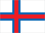
- <strong>description:</strong> white with a red cross outlined in blue that extends to the edges of the flag; the cross is shifted toward the left side in the style of the Dannebrog (Danish flag)<br><br><strong>meaning:</strong> white represents waves breaking on the shore; red and blue are traditional Faroese colors<br><br><strong>history:</strong> the flag is referred to as Merkid, meaning "the banner" or "the mark;" a group of students designed it in 1919, although it wasn't officially adopted until 1940
- note
- <strong>note:</strong> resembles the flags of Iceland and Norway; uses the same three colors in a different sequence and with a lighter blue
Flag description
The flag of the Faroe Islands is white with a red cross outlined in blue extending to the edges of the flag. The vertical part of the cross is shifted toward the hoist side.
Flag image
- svg
- https://flagcdn.com/fo.svg
Government type
parliamentary democracy (Faroese Parliament); part of the Kingdom of Denmark
Independence
none (self-governing overseas administrative division of Denmark)
International organization participation
Arctic Council, IMO (associate), NC, NIB, UNESCO (associate), UPU
Judicial branch
- Highest court(s)
- Faroese Court or Raett (Rett in Danish) decides both civil and criminal cases; the Court is part of the Danish legal system
- Subordinate courts
- Court of the First Instance or Tribunal de Première Instance; Court of Administrative Law or Tribunal Administratif; Mixed Commercial Court; Land Court
Legal system
the laws of Denmark apply
Legislative branch
- Electoral system
- proportional representation
- Expected date of next election
- 2026
- Legislative structure
- unicameral
- Legislature name
- Faroese Parliament (Logting)
- Most recent election date
- 12/8/2022
- Note
- <strong>note:</strong> the Faroe Islands elect 2 members to the Danish Parliament to serve 4-year terms
- Number of seats
- 33 (directly elected)
- Parties elected and seats per party
- JF (9); B (7); A (6); E (6); F (3); H (2)
- Percentage of women in chamber
- 27.3%
- Scope of elections
- full renewal
- Term in office
- 4 years
National holiday
- Olaifest (Olavsoka), 29 July (1030)
- note
- <strong>note: </strong>commemorates the death in battle of King OLAF II of Norway, later St. OLAF
National symbol(s)
ram
Political parties
Center Party or H (Midflokkurin) <br>People's Party or A (Folkaflokkurin) <br>Progress Party or F (Framsokn) <br>Republic or E (Tjodveldi) (formerly the Republican Party)<br>Social Democratic Party or JF (Javnadarflokkurin) or JF <br>Union Party or B (Sambandsflokkurin)
Start of week
Monday
Suffrage
18 years of age; universal
UN Member
No
Economy
Agricultural products
- milk, potatoes, lamb/mutton, sheepskins, sheep offal, beef, sheep fat, beef offal, cattle hides, beef suet (2023)
- note
- <b>note:</b> top ten agricultural products based on tonnage
Currency
- code
- DKK, FOK
- name
- Danish krone (DKK) [kr], Faroese króna (FOK) [kr]
Economic overview
high-income Danish territorial economy; party neither to the EU nor the Schengen Area; associate Nordic Council member; very low unemployment; unique foreign ownership allowance in fishing industry; known salmon exporter; growing IT industries
Exchange rates
- Currency
- Danish kroner (DKK) per US dollar -
- Exchange rates 2020
- 6.542 (2020 est.)
- Exchange rates 2021
- 6.287 (2021 est.)
- Exchange rates 2022
- 7.076 (2022 est.)
- Exchange rates 2023
- 6.89 (2023 est.)
- Exchange rates 2024
- 6.894 (2024 est.)
Exports
- $2.21 billion
- Exports 2021
- $1.923 billion (2021 est.)
- Exports 2022
- $2.219 billion (2022 est.)
- Exports 2023
- $2.255 billion (2023 est.)
- Note
- <strong>note: </strong>GDP expenditure basis - exports of goods and services in current dollars
Exports - commodities
fish and fish products (2021)
Exports - partners
Russia 26.4%, UK 14.1%, Germany 8.4%, China 7.9%, Spain 6.8%, Denmark 6.2%, US 4.7%, Poland 4.4%, Norway 4.1% (2017)
GDP - composition, by end use
- Exports of goods and services
- 57.7% (2023 est.)
- Government consumption
- 27.3% (2023 est.)
- Household consumption
- 40.6% (2023 est.)
- Imports of goods and services
- -56.6% (2023 est.)
- Investment in fixed capital
- 31% (2023 est.)
- Investment in inventories
- 0% (2023 est.)
- Note
- <strong>note:</strong> figures may not total 100% due to rounding or gaps in data collection
GDP - composition, by sector of origin
- Agriculture
- 18.2% (2023 est.)
- Industry
- 19.7% (2023 est.)
- Note
- <b>note:</b> figures may not total 100% due to non-allocated consumption not captured in sector-reported data
- Services
- 52% (2023 est.)
GDP (official exchange rate)
- $3.907 billion (2023 est.)
- note
- <b>note:</b> data in current dollars at official exchange rate
GDP per capita (nominal)
$74,120
GNI (gross national income)
$4.12 billion
GNI per capita
$73,070
Gross domestic investment
28 % of GDP
Imports
- $2.07 billion
- Imports 2021
- $1.906 billion (2021 est.)
- Imports 2022
- $2.223 billion (2022 est.)
- Imports 2023
- $2.212 billion (2023 est.)
- Note
- <strong>note: </strong>GDP expenditure basis - imports of goods and services in current dollars
Imports - commodities
goods for household consumption, machinery and transport equipment, fuels, raw materials and semi-manufactures, cars
Imports - partners
Denmark 33%, China 10.7%, Germany 7.6%, Poland 6.8%, Norway 6.7%, Ireland 5%, Chile 4.3% (2017)
Industries
fishing, fish processing, tourism, small ship repair and refurbishment, handicrafts
Real GDP (purchasing power parity)
- $4.48 billion
- Note
- <b>note:</b> data in 2021 dollars
- Real GDP (purchasing power parity) 2021
- $3.613 billion (2021 est.)
- Real GDP (purchasing power parity) 2022
- $3.741 billion (2022 est.)
- Real GDP (purchasing power parity) 2023
- $3.834 billion (2023 est.)
Real GDP growth rate
- 0.84%
- Note
- <b>note:</b> annual GDP % growth based on constant local currency
- Real GDP growth rate 2021
- 5.5% (2021 est.)
- Real GDP growth rate 2022
- 3.6% (2022 est.)
- Real GDP growth rate 2023
- 2.5% (2023 est.)
Real GDP per capita
- $81,909
- Note
- <b>note:</b> data in 2021 dollars
- Real GDP per capita 2021
- $67,800 (2021 est.)
- Real GDP per capita 2022
- $69,400 (2022 est.)
- Real GDP per capita 2023
- $70,400 (2023 est.)
Remittances
- Note
- <b>note:</b> personal transfers and compensation between resident and non-resident individuals/households/entities
- Remittances 2021
- 4.3% of GDP (2021 est.)
- Remittances 2022
- 4.4% of GDP (2022 est.)
- Remittances 2023
- 4.1% of GDP (2023 est.)
Energy
Coal
- Imports
- 1 metric tons (2023 est.)
Electricity
- Consumption
- 463.285 million kWh (2023 est.)
- Installed generating capacity
- 180,000 kW (2023 est.)
- Transmission/distribution losses
- 25.115 million kWh (2023 est.)
Electricity access
- Electrification - rural areas
- 100%
- Electrification - total population
- 100% (2022 est.)
- Electrification - urban areas
- 99.9%
Electricity generation sources
- Biomass and waste
- 1% of total installed capacity (2023 est.)
- Fossil fuels
- 53.7% of total installed capacity (2023 est.)
- hydroelectric
- 23.67%
- Hydroelectricity
- 26.8% of total installed capacity (2023 est.)
- nuclear
- 0%
- renewable
- 38.08%
- Wind
- 18.4% of total installed capacity (2023 est.)
Petroleum
- Refined petroleum consumption
- 5,000 bbl/day (2023 est.)
Renewable energy consumption
7.9%
Communications
Broadband - fixed subscriptions
- per 100 inhabitants
- 35 per 100
- Subscriptions per 100 inhabitants
- 35 (2022 est.)
- Total
- 19,000 (2022 est.)
Broadcast media
1 publicly owned TV station; the Faroese telecommunications company distributes local and international channels through its digital terrestrial network; publicly owned radio station supplemented by 3 privately owned stations broadcasting over multiple frequencies
Internet country code
.fo
Internet users
- Percent of population
- 98% (2017 est.)
Postal code format
FO-###
Telephone calling code
+298
Telephones - fixed lines
- Subscriptions per 100 inhabitants
- 28 (2022 est.)
- Total subscriptions
- 15,000 (2021 est.)
Telephones - mobile cellular
- subscriptions per 100
- 106 per 100
- Subscriptions per 100 inhabitants
- 106 (2022 est.)
- Total subscriptions
- 57,146 (2022 est.)
Transportation
Airports
1 (2025)
Civil aircraft registration country code prefix
OY-H
Driving side
Right
Heliports
12 (2025)
Merchant marine
- By type
- container ships 6, general cargo 45, other 40
- Total
- 91 (2023)
Ports
- Key ports
- Fuglafjordur, Klaksvik, Kongshavn, Runavik, Sorvagur, Torshavn, Tvoroyri, Vagur, Vestmanna
- Large
- 0
- Medium
- 0
- Ports with oil terminals
- 5
- Small
- 0
- Total ports
- 9 (2024)
- Very small
- 9
Vehicle registration code
FO
Military and Security
Military - note
the Government of Denmark has responsibility for defense; as such, the Danish military’s Joint Arctic Command in Nuuk, Greenland is responsible for coordinating the defense of the Faroe Islands; the Joint Arctic Command has a contact element in the capital of Torshavn
Military and security forces
no regular military forces or conscription
Environment
Carbon dioxide emissions
- From petroleum and other liquids
- 742,000 metric tonnes of CO2 (2023 est.)
- Total emissions
- 742,000 metric tonnes of CO2 (2023 est.)
Environmental issues
coastal erosion, landslides and rockfalls, flash flooding, wind storms; oil spills
Protected areas
0 % of total land area
Renewable electricity output
14 % of total
Waste and recycling
- Municipal solid waste generated annually
- 61,000 tons (2024 est.)
- Percent of municipal solid waste recycled
- 67% (2012 est.)