1989 Edition
CIA World Factbook 1989 (Internet Archive)
Geography
Agriculture
mainly subsistence farming except for rubber plantations; main crops — rice, rubber, corn; food shortages — rice, meat, vegetables, dairy products, sugar, flour
Aid
US commitments, including Ex-Im (FY70-88), $719 million; Western (nonUS) countries (1970-85), $270 million; Communist countries (1970-88), $950 million
Budget
revenues $NA; expenditures $NA, including capital expenditures of SNA
Climate
varies with terrain from tropical along coast to semiarid and hot in north
Coastline
402 km
Comparative area
slightly larger than California
Continental shelf
not specific
Currency
riel (plural — riels); 1 riel (CR) = 100 sen
Disputes
exact locations of the Chad-Niger-Nigeria and Cameroon-ChadNigeria tripoints in Lake Chad have not been determined, so the boundary has not been demarcated and border incidents have resulted; Nigerian proposals to reopen maritime boundary negotiations and redemarcate the entire land boundary have been rejected by Cameroon
Electricity
126,000 kW capacity; 150 million kWh produced, 21 kWh per capita (1989)
Environment
recent volcanic activity with release of poisonous gases; deforestation; overgrazing; desertification
Exchange rates
riels (CR) per US$1— 218 (November 1989) 100.00 (1987), 30.00 (1986), 7.00 (1985)
Exports
$32 million (f.o.b., 1988); commodities— natural rubber, rice, pepper, wood; partners — Vietnam, USSR, Eastern Europe, Japan, India
External debt
$600 million (1989)
Fiscal year
calendar year
GDP
$890 million, per capita $130; real growth rate 0% (1989 est.)
Imports
$147 million (c.i.f., 1988); commodities— international food aid; fuels, consumer goods; partners — Vietnam, USSR, Eastern Europe, Japan, India
Industrial production
growth rate NA%
Industries
rice milling, fishing, wood and wood products, rubber, cement, gem mining
Inflation rate (consumer prices)
NA%
Land boundaries
4,591 km total; Central African Republic 797 km, Chad 1,094 km, Congo 523 km, Equatorial Guinea 189 km, Gabon 298 km, Nigeria 1,690 km
Land use
13% arable land; 2% permanent crops; 18% meadows and pastures; 54% forest and woodland; 1 3% other; includes NEGL% irrigated
Natural resources
crude oil, bauxite, iron ore, timber, hydropower potential
Note
sometimes referred to as the hinge of Africa
Terrain
diverse with coastal plain in southwest, dissected plateau in center, mountains in west, plains in north
Territorial sea
50 nm
Total area
475,440 km2; land area: 469,440 km2
Unemployment rate
NA%
People and Society
Birth rate
42 births/ 1,000 population (1990) Cameroon (continued)
Death rate
15 deaths/ 1,000 population (1990)
Ethnic divisions
over 200 tribes of widely differing background; 31% Cameroon Highlanders, 19% Equatorial Bantu, 11% Kirdi, 10% Fulani, 8% Northwestern Bantu, 7% Eastern Nigritic, 1 3% other African, less than 1% nonAfrican
Infant mortality rate
120 deaths/ 1,000 live births (1990)
Labor force
NA; 74.4% agriculture, 11.4% industry and transport, 14.2% other services (1983); 50% of population of working age (15-64 years) (1985)
Language
English and French (official), 24 major African language groups
Life expectancy at birth
49 years male, 53 years female (1990)
Literacy
56.2%
Nationality
noun — Cameroonian(s); adjective— Cameroonian
Net migration rate
0 migrants/ 1 ,000 population (1990)
Organized labor
under 45% of wage labor force
Population
1 1,092,470 (July 1990), growth rate 2.7% (1990)
Religion
51% indigenous beliefs, 33% Christian, 16% Muslim
Total fertility rate
5.7 children born/ woman (1990)
Government
Administrative divisions
10 provinces; Adamaoua, Centre, Est, Extreme-Nord, Littoral, Nord, Nord-Ouest, Quest, Sud, Sud-Ouest
Capital
Yaounde
Communists
no Communist party or significant number of sympathizers
Constitution
20 May 1972
Diplomatic representation
Ambassador Paul PONDI; Chancery at 2349 Massachusetts Avenue NW, Washington DC 20008; telephone (202) 265-8790 through 8794; US— Ambassador Frances COOK; Embassy at Rue Nachtigal, Yaounde (mailing address is B. P. 817, Yaounde); telephone [237] 234014; there is a US Consulate General in Douala
Elections
President — last held 24 April 1988 (next to be held April 1993); results — President Paul Biya reelected without opposition; National Assembly — last held 24 April 1988 (next to be held April 1993); results — RDPC is the only party; seats — (180 total) RDPC 180
Executive branch
president, Cabinet
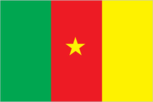
Flag
three equal vertical bands of green (hoist side), red, and yellow with a yellow five-pointed star centered in the red band; uses the popular pan-African colors of
Independence
1 January 1 960 (from UN trusteeship under French administration; formerly French Cameroon)
Judicial branch
Supreme Court
Leaders
Chief of State and Head of Government President Paul BIYA (since 6 November 1982) Political parties and leaders: only party — Cameroon People's Democratic Movement (RDPC), Paul Biya, president
Legal system
based on French civil law system, with common law influence; has not accepted compulsory ICJ jurisdiction
Legislative branch
unicameral National Assembly (Assemblee Nationale)
Long-form name
Republic of Cameroon
Member of
ACP, AfDB, CCC, EAMA, ECA, EIB (associate), FAO, G-77, GATT, IAEA, IBRD, ICAC, ICAO, ICO, IDA, IDB — Islamic Development Bank, IFAD, IFC, ILO, IMF, IMO, INTELSAT, INTERPOL, IPU, ISO, ITU, Lake Chad Basin Commission, NAM, Niger River Commission, OAU, QIC, UDEAC, UN, UNESCO, UPU, WHO, WIPO, WMO, WTO
National holiday
National Day, 20 May (1972)
Other political or pressure groups
Cameroon People's Union (UPC), remains an illegal group with its factional leaders in exile
Suffrage
universal at age 21
Type
unitary republic; one-party presidential regime
Communications
Airports
22 total, 9 usable; 6 with permanent-surface runways; none with runways over 3,659 m; 2 with runways 2,440-3,659 m; 4 with runways 1, 220-2,439 m
Branches
PRK— People's Republic of Kampuchea Armed Forces; Communist resistance forces — National Army of Democratic Kampuchea (Khmer Rouge); non-Communist resistance forces — Sihanoukist National Army (ANS) and Khmer People's National Liberation Front (KPNLF)
Defense expenditures
NA 300km
Highways
13,351 km total; 2,622 km bituminous; 7,105 km crushed stone, gravel, or improved earth; 3,624 km unimproved earth; some roads in disrepair
Inland waterways
3,700 km navigable all year to craft drawing 0.6 meters; 282 km navigable to craft drawing 1 .8 meters
Military manpower
males 15-49, 1,857,129; 1,025,456 fit for military service; 61,649 reach military age (18) annually
Ports
Kampong Saom, Phnom Penh
Railroads
612 km 1.000-meter gauge, government owned
Telecommunications
service barely adequate for government requirements and virtually nonexistent for general public; international service limited to Vietnam and other adjacent countries; stations — 1 AM, no FM, 1 TV Defense Forces